
The geography of Switzerland encompasses the geographical features of Switzerland, a mountainous and landlocked country located in Western and Central Europe. Switzerland's natural landscape is marked by its numerous lakes and mountains. It is surrounded by 5 countries: Austria and Liechtenstein to the east, France to the west, Italy to the south and Germany to the north. Switzerland has a maximum north–south length of 220 kilometres (140 mi) and an east–west length of about 350 kilometres (220 mi).

Lake Geneva is a deep lake on the north side of the Alps, shared between Switzerland and France. It is one of the largest lakes in Western Europe and the largest on the course of the Rhône. Sixty per cent of the lake belongs to Switzerland and forty per cent to France.
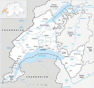
Vaud, more formally the canton of Vaud, is one of the 26 cantons forming the Swiss Confederation. It is composed of ten districts and its capital city is Lausanne. Its flag bears the motto "Liberté et patrie" on a white-green background.
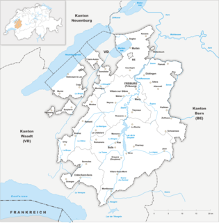
The canton of Fribourg, also canton of Freiburg is located in western Switzerland. The canton is bilingual, with French spoken by more than two thirds of the citizens and German by a little more than a quarter. Both are official languages in the canton. The canton takes its name from its capital city of Fribourg.

Les Portes du Soleil is a major skisports destination in the Alps, encompassing thirteen resorts between Mont Blanc in France and Lake Geneva in Switzerland. With more than 650 km of marked pistes and about 200 lifts in total, spread over 14 valleys and about 1,036 square kilometres (400 sq mi), Portes du Soleil ranks among the two largest ski areas in the world. Almost all of the pistes are connected by lifts – a few marginal towns can be reached only by the free bus services in the area. The highest altitude accessible on skis is 2260m and the lowest is 930m. As with many other Alpine ski resorts, the lower slopes of the Portes du Soleil have snow-making facilities to extend the ski season by keeping the lower slopes open during the warmer months.

The Finsteraarhorn is a mountain lying on the border between the cantons of Bern and Valais. It is the highest mountain of the Bernese Alps and the most prominent peak of Switzerland. The Finsteraarhorn is the ninth-highest mountain and third-most prominent peak in the Alps. In 2001 the whole massif and surrounding glaciers were designated as part of the Jungfrau-Aletsch World Heritage Site.

The Dom is a mountain of the Pennine Alps, located between Randa and Saas-Fee in the canton of Valais in Switzerland. With a height of 4,545 m (14,911 ft), it is the seventh highest summit in the Alps, overall. Based on prominence, it can be regarded as the third highest mountain in the Alps, and the second highest in Switzerland, after Monte Rosa. The Dom is the main summit of the Mischabel group, which is the highest massif lying entirely in Switzerland.

The Weissmies 4,017 m (13,179 ft) is a mountain in the Pennine Alps in the canton of Valais in Switzerland near the village of Saas-Fee. It is the easternmost four-thousander of its range.

La Dôle is a mountain of the Jura, overlooking Lake Geneva in the westernmost part of the canton of Vaud. Rising to an altitude of 1677 meters, it is the second highest peak in the Swiss portion of the Jura, after Mont Tendre. Administratively, the summit is split between the municipalities of Gingins, Chéserex and La Rippe. The mountain is also close to and easily accessible from Saint-Cergue and the Col de la Givrine to the north, both above 1000 meters and connected to Nyon on Lake Geneva by road and by the Nyon–St-Cergue–Morez Railway. A paved road also climbs to the Chalet de la Dôle below the summit from Gingins.

Matheysine is a French Natural region located in the Alps at the south of the Isère département. Its relief is a plateau surrounded by mountains. Matheysine is also called Plateau Matheysin.

The Wildhorn is a mountain of the Alps, straddling the border between the Swiss cantons of Bern and Valais. At 3,248 metres (10,656 ft) above sea level, it is the highest summit of the Bernese Alps west of the Gemmi Pass. It forms a large glaciated massif, about 10 km wide, extending between the Sanetsch Pass and the Rawil Pass. Along with the Muverans, the Diablerets and the Wildstrubel, the Wildhorn is one of the four distinct mountain massifs of the Bernese Alps that lie west of the Gemmi Pass. The massif of the Wildhorn is at the centre between the valleys of the Saane, Simme and the Rhone (Valais). It comprises several distinct summits, including the Arpelistock, Le Sérac, the Geltenhorn, the Sex Noir, the Sex Rouge, the Schnidehorn and the Six des Eaux Froides. The main crest is between the glaciers named Tungelgletscher and Glacier du Wildhorn. South of the main summit is the almost equally high summit of Mont Pucel. The Wildhorn is surrounded by several large mountain lakes: the Lac de Sénin, the Lauenensee, the Iffigsee, the Lac de Tseuzier and the Lac des Audannes. The Tungelgletscher, on the north-east face, was measured as 1.9 km in length in 1973.

La Chapelle-d'Abondance is a commune in the Haute-Savoie department in the Auvergne-Rhône-Alpes region in south-eastern France.
The Cornettes de Bise is a mountain in the Chablais Alps, overlooking Lake Geneva. At 2,432 metres above sea level, it is the highest summit of the subrange running from Pas de Morgins to Lake Geneva. The mountain is located on the border between France (west) and Switzerland (east).

The Dent de Lys is a mountain in the Bernese Alps, in the canton of Fribourg.
The Berneuse is a mountain of the western Bernese Alps, above Leysin in the canton of Vaud. It lies on the range east of the Rhone valley, culminating at the Tour d'Aï.

Les Diablerets is a village and ski resort located in the municipality of Ormont-Dessus in the canton of Vaud, Switzerland.

Teysachaux is a mountain of the Swiss Prealps, overlooking Les Paccots in the canton of Fribourg.

Les Paccots is a village and a small ski resort of the Swiss Prealps, located in the canton of Fribourg.
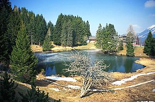
The lac des Joncs is a small mountain lake located in Les Paccots, canton of Fribourg, in Switzerland.

The Niremont is a mountain of the Swiss Prealps, in the canton of Fribourg. Due to its rounded shape, it has 2 sub-summits : The Gros Niremont and the Petit Niremont.

