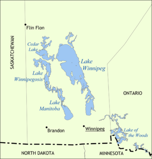
Lake Winnipeg is a very large, but relatively shallow 24,514-square-kilometre (9,465 sq mi) lake in North America, in the province of Manitoba, Canada. Its southern end is about 55 kilometres (34 mi) north of the city of Winnipeg. It is the largest lake within southern Canada's borders, and is part of the most undeveloped large watershed of southern Canada.
Lake Winnipegosis is a large (5,370 km²) lake in central North America, in Manitoba, Canada, some 300 km northwest of Winnipeg. It is Canada's eleventh-largest lake. An alternate spelling, once common but now rare, is Lake Winipigoos or simply 'Lake Winipigis'.
Beaver Creek may refer to:

The Souris River or Mouse River is a river in central North America. It is about 700 km (435 mi) in length and drains about 23,600 square miles (61,100 km2). It rises in the Yellow Grass Marshes north of Weyburn, Saskatchewan. It wanders south through North Dakota beyond Minot to its most southern point at the city of Velva, and then back north into Manitoba. The river passes through the communities of Melita, Hartney, Souris and Wawanesa and on to its confluence with the Assiniboine River at Treesbank, about 25 miles (40 km) south east of Brandon. The main tributaries which flow into the Souris in Manitoba are the Antler River, the Gainsborough and Plum Creeks. Much of its drainage basin is fertile silt and clay deposited by former glacial Lake Souris.
The Winnipeg River is a Canadian river which flows roughly northwest from Lake of the Woods in the province of Ontario to Lake Winnipeg in Manitoba. This river is 235 kilometres (146 mi) long from the Norman Dam in Kenora to its mouth at Lake Winnipeg. Its watershed is 106,500 square kilometres (41,100 sq mi) in area, mainly in Canada. About 29,000 square kilometres (11,000 sq mi) of the watershed is in northern Minnesota, United States.

The Hayes River is a river in Northern Region, Manitoba, Canada that flows from Molson Lake to Hudson Bay at York Factory. It was an historically important river in the development of Canada, and is today a Canadian Heritage River and the longest naturally flowing river in Manitoba.

East St. Paul is a rural municipality in Manitoba, Canada. It is located north-east of and adjacent to the city of Winnipeg, and is part of the Winnipeg Metropolitan Area. The municipality was formed on 3 November 1915 when the municipality of St. Paul (1888-1914) was subdivided into West St. Paul and East St. Paul, with the Red River acting as the dividing line. It encompasses 41 square kilometres (16 sq mi).
Treaty 2 was entered in to on 21 August 1871 at Manitoba House, Rupertsland with Representatives of the Queen of England and Ireland. The original Anishinaabe, who were present constitute Treaty 2 today. It is known that many of the Chiefs and leaders within the territory were at the early gathering and after the treaty was agreed to. Those who were not present were represented through Mekis until they indicated where they wished their farming reserves to be established. The Treaty reaffirmed the Inherent rights that the Anishinaabek had prior to European contact. Located in where southwestern Manitoba is today and a small part of southeastern Saskatchewan;

Division No. 19, also informally known as North East Manitoba, is a census division in the Canadian province of Manitoba. Division No. 19 actually extends all the way across the province from west to east at near its middle, although the overwhelming majority of its territory is located in its eastern and southeastern portions. It includes most of Lake Winnipeg, most of Lake Winnipegosis, and some of the north basin of Lake Manitoba.The Northern Region of Manitoba begins at the 53rd Parallel is known as Norman region denoting the start of Northern Manitoba.

Spruce Woods Provincial Park is located in south-central Manitoba, Canada where the Assiniboine River passes through the delta of sediment left by the last glaciation. An area of open and stabilized sand dunes within the park provides habitat to species of plants and animals not found elsewhere in Manitoba. In descending order of land area contained, the park lies within the Rural Municipalities of South Cypress, Victoria, and North Cypress.
Census Division No. 15 Western Manitoba is part of the Westman Region of the province of Manitoba, Canada. The economy of the region is based on agriculture, livestock and hog processing. The population of the area based on the 2006 census was 21,417. Also included in the division are the main reserves of the Birdtail Sioux First Nation, the Keeseekoowenin Ojibway First Nation, and the Rolling River First Nation.
Provincial Highway 13 by the Manitoba Infrastructure and Transportation is a Regional Transportation Advisory Committee RTAC Route of Manitoba. The RTAC route is capable of handling RTAC vehicles such as a truck, a truck and pony trailer, a truck and full trailer, a truck tractor and semi-trailer, an A-train, a B-train, or a C-train. The route extends south to north from its junction with PTH 3 and PR 245 in Carman to its junction with PTH 1 and PR 430 north of Oakville. The northern terminus of PTH 13 is located between Portage la Prairie and Manitoba's capital city Winnipeg. The Central Manitoba Railway (CEMR) shortline rail intersects PTH 13 north of Carman, the Canadian Pacific Railway (CPR) intersects at Elm Creek, and the Canadian National Railway (CNR) at Oakville.
The Rural Municipality of Shell River was a rural municipality (RM) in the Canadian province of Manitoba. It was incorporated as a rural municipality on December 22, 1883. On January 1, 2015 it was amalgamated as a result a provincial government mandate with the RM of Hillsburg and the Town of Roblin to form the Municipality of Hillsburg – Roblin – Shell River.

The Whitefish River is a river in Census Division 21 in the Northern Region of Manitoba, Canada. It is in the Hudson Bay and Nelson River drainage basins and is a left tributary of the Saskatchewan River.
The Echoing River is a river in the Hudson Bay drainage basin in Manitoba and Ontario, Canada. Its flows from its source at Echoing Lake in Unorganized part of Kenora District, Northwestern Ontario to its mouth at the Gods River in Northern Manitoba. The Gods River flows via the Hayes River to Hudson Bay.

The Mistik Creek is a river in the Hudson Bay drainage basin in the Northern Region of Manitoba, Canada, approximately 20 kilometres (12 mi) northeast of Bakers Narrows.

Vamp Creek is a river in the Hudson Bay drainage basin in the Northern Region of Manitoba, Canada, approximately 25 kilometres (16 mi) northeast of Bakers Narrows.
Leslie Creek may refer to:


