
Trinity County is a county located in the northwestern portion of the U.S. state of California. Trinity County is rugged, mountainous, heavily forested, and lies along the Trinity River within the Salmon and Klamath Mountains. It is also one of three counties in California with no incorporated cities.

The Pit River is a major river draining from northeastern California into the state's Central Valley. The Pit, the Klamath and the Columbia are the only three rivers in the U.S. that cross the Cascade Range.

The Trinity River is a major river in northwestern California in the United States and is the principal tributary of the Klamath River. The Trinity flows for 165 miles (266 km) through the Klamath Mountains and Coast Ranges, with a watershed area of nearly 3,000 square miles (7,800 km2) in Trinity and Humboldt Counties. Designated a National Wild and Scenic River, along most of its course the Trinity flows swiftly through tight canyons and mountain meadows.

Pyramid Lake is a reservoir formed by Pyramid Dam on Piru Creek in the eastern San Emigdio Mountains, near Castaic, Southern California. It is a part of the West Branch California Aqueduct, which is a part of the California State Water Project. Its water is fed by the system after being pumped up from the San Joaquin Valley and through the Tehachapi Mountains.
Shasta Lake, also popularly known as Lake Shasta, is a reservoir in Shasta County, California, United States. It began to store water in 1944 due to the impounding of the Sacramento River by Shasta Dam, the ninth tallest dam in the United States.

A national recreation area (NRA) is a protected area in the United States established by an Act of Congress to preserve enhanced recreational opportunities in places with significant natural and scenic resources. There are 40 NRAs, which emphasize a variety of activities for visitors, including hiking, camping, boating, fishing, swimming, biking, horseback riding, and wildlife viewing, in areas that include multiple-use management for both conservation and limited utilization of natural resources. They have diverse features and contexts, being established around reservoirs, in urban areas, and within forests. Due to their size, diversity of activities, and proximity to population centers, NRAs are among the most visited units of the National Park System, with six among the thirty most visited sites.
Don Pedro Reservoir, also known as Lake Don Pedro, is a reservoir formed by the construction of the New Don Pedro Dam across the Tuolumne River in Tuolumne County, California, United States.

Trinity Dam is an earthfill dam on the Trinity River located about 7 miles (11 km) northeast of Weaverville, California in the United States. The dam was completed in the early 1960s as part of the federal Central Valley Project to provide irrigation water to the arid San Joaquin Valley.

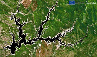
Trinity Lake, previously called Clair Engle Lake, is an reservoir on the Trinity River formed by the Trinity Dam and located in Trinity County, California, United States. The dam was built by the U.S. Bureau of Reclamation. The lake's capacity is 2,447,650 acre⋅ft (3,019.13 GL), making it one of the largest reservoirs in California. The lake's surface is at 2,370 ft (720 m) above MSL. Trinity Lake captures and stores water for the Central Valley Project, which provides the Central Valley with water for irrigation and produces hydroelectric power. This lake is known for its many small arms, glassy inlets, and good water-skiing conditions.

The Shasta–Trinity National Forest is a federally designated forest in northern California, United States. It is the largest National Forest in California and is managed by the U.S. Forest Service. The 2,210,485 acre forest encompasses five wilderness areas, hundreds of mountain lakes and 6,278 miles (10,103 km) of streams and rivers. Major features include Shasta Lake, the largest man-made lake in California and Mount Shasta, elevation 14,179 feet (4,322 m).

The Trinity Mountains are a subrange of the Klamath Mountains, one of the ranges within the California Coast Ranges and part the greater Pacific Coast Ranges, the coastal mountain system extending from Mexico to Alaska. The Trinity Mountains subrange rises in Siskiyou County and eastern Trinity County, Northern California.

Castaic Lake is a reservoir formed by Castaic Dam on Castaic Creek, in the Sierra Pelona Mountains of northwestern Los Angeles County, California, United States, near the town of Castaic.

Lake McClure is a reservoir in the Sierra Nevada foothills of western Mariposa County, California, United States.

The Whiskeytown–Shasta–Trinity National Recreation Area is a United States National Recreation Area in northern California. The recreation area was authorized in 1965 by the United States Congress. Recreational activities available include swimming, fishing, boating, camping, and hiking.

Whiskeytown Lake is a reservoir in Shasta County in northwestern California, United States, about 8 miles (13 km) west of Redding. The lake is in the Whiskeytown Unit of the Whiskeytown-Shasta-Trinity National Recreation Area.

The Klamath Basin is the region in the U.S. states of Oregon and California drained by the Klamath River. It contains most of Klamath County and parts of Lake and Jackson counties in Oregon, and parts of Del Norte, Humboldt, Modoc, Siskiyou, and Trinity counties in California. The 15,751-square-mile (40,790 km2) drainage basin is 35% in Oregon and 65% in California. In Oregon, the watershed typically lies east of the Cascade Range, while California contains most of the river's segment that passes through the mountains. In the Oregon-far northern California segment of the river, the watershed is semi-desert at lower elevations and dry alpine in the upper elevations. In the western part of the basin, in California, however, the climate is more of temperate rainforest, and the Trinity River watershed consists of a more typical alpine climate.

Silverwood Lake is a large reservoir in San Bernardino County, California, United States, located on the West Fork Mojave River, a tributary of the Mojave River in the San Bernardino Mountains. It was created in 1971 as part of the State Water Project by the construction of the Cedar Springs Dam as a forebay on the 444 mi (715 km) long California Aqueduct, and has a capacity of 73,000 acre⋅ft (90,000,000 m3).

Lake McCloud is a reservoir on the McCloud River in Northern California. The lake forms behind an earthen dam finished in 1965 by the Pacific Gas and Electric Company to control water flows and for generating hydro-electric power. McCloud Dam is 235 feet (72 m) high, 630 feet (190 m) long at its crest, and impounds a maximum capacity of 35,200 acre-feet (43,400,000 m3).

Whiskeytown Dam is an earthfill dam on Clear Creek, a tributary of the Sacramento River of northern California in the United States.
Iron Canyon Dam is a dam in Shasta County, California, United States.


