
Leyton is a town in East London, England, within the London Borough of Waltham Forest. It borders Walthamstow to the north, Leytonstone to the east, and Stratford to the south, with Clapton, Hackney Wick and Homerton, across the River Lea, to the west. The area includes New Spitalfields Market, Leyton Orient Football Club, as well as part of the Queen Elizabeth Olympic Park. The town consists largely of terraced houses built between 1870 and 1910, interspersed with some modern housing estates. It is 6.2 miles (10 km) north-east of Charing Cross.
Walthamstow is a town within the London Borough of Waltham Forest in east London. The town borders Chingford to the north, Snaresbrook and South Woodford to the east, Leyton and Leytonstone to the south, and Tottenham to the west. At the 2011 census, Walthamstow had a population of approximately 109,424 and is around 7.5 miles (12 km) north-east of Central London.

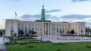
The London Borough of Waltham Forest is an outer London borough formed in 1965 from the merger of the municipal boroughs of Leyton, Walthamstow and Chingford.

Leytonstone is an area in East London, England, within the London Borough of Waltham Forest. It adjoins Wanstead to the north-east, Forest Gate to the south-east, Stratford to the south-west, Leyton to the west, and Walthamstow to the north-west, and is 7 miles (11 km) north-east of Charing Cross.

Leyton is a London Underground station in Leyton, in the London Borough of Waltham Forest, East London. Located on Leyton High Road, adjacent to the A12, the station is on the Central line between Stratford and Leytonstone stations. It is in Travelcard zone 3.

Sheldon School is a large mixed secondary school and sixth form in Chippenham, Wiltshire for students aged 11 to 18 and is the largest school in Wiltshire. Since April 2011, it has been an Academy. It is one of three secondary schools in Chippenham, the others being Abbeyfield and Hardenhuish. The school is headed by Peter Lynch, former Headteacher of Bradley Stoke Community School, who was appointed in September 2023. The school is off the Hardenhuish Lane in the southern region of Hardenhuish Park, which is all that separates it from Hardenhuish School to the north.

Leyton and Wanstead is a constituency in Greater London created in 1997 and represented in the House of Commons of the UK Parliament since 2024 by Calvin Bailey of the Labour Party.
All Saints Catholic School is a Roman Catholic secondary school located on Terling Road, Dagenham in the London Borough of Barking and Dagenham, England.

Leyton was a local government district in southwest Essex, England, from 1873 to 1965. It included the neighbourhoods of Leyton, Leytonstone and Cann Hall. It was suburban to London, forming part of the London postal district and Metropolitan Police District. It now forms the southernmost part of the London Borough of Waltham Forest in Greater London.

Wanstead Flats is the southernmost portion of Epping Forest, in Leytonstone and Wanstead, London. The flats and by extension the forest ends at Forest Gate directly to the south. It now falls wholly within the boundaries of the London Boroughs of Redbridge and Waltham Forest, though until 1994 two parts of it were in the London Borough of Newham: one of these was the section between Aldersbrook Road and Capel Road east of the junction between Aldersbrook Road and St Margaret's Road, whilst the other was the strip running along Capel Road between its junctions with Centre Road and Ridley Road. As part of Epping Forest, the Flats is managed by the City of London Corporation.

Newham Sixth Form College (NewVIc) is a sixth form college located in the East London borough of Newham. Situated on a single site in Plaistow, the college was established in 1992 to provide for students in Newham and neighbouring boroughs who opt to stay in education beyond GCSE O-levels. It is designed for students ages 16 to 19 and its curriculum includes A-levels as well as specialist pathway, levels 2 and 3 vocational, foundation level and ESOL programmes. The college at one time had an enrolment of about 2,500 students.

Mulberry Academy Woodside is a mixed 11–16 academy located in the Wood Green area of the London Borough of Haringey, England. With a student roll of 1200, the school has been judged by Ofsted as outstanding for two consecutive inspections.

Hameldon Community College was a mixed 11–16 comprehensive school located in Burnley, Lancashire, England.

Norlington School is a boys' secondary school and coeducational sixth form located in the London Borough of Waltham Forest, in East London. The school is situated on Norlington Road in Leyton.
Chingford Foundation School is a coeducational state secondary school and sixth form located in Chingford in the London Borough of Waltham Forest. It is a specialist Humanities College and has been an academy since October 2012.
Connaught School for Girls is a single-sex girls' secondary school and comprehensive school situated in Leytonstone, London. It educates up to 636 girls between the ages of 11 and 16. In February 2013 it became an academy.

Leyton Sixth Form College or LSC is a public sixth form college located in the southern part of the London Borough of Waltham Forest. There are over 2,100 learners, of which 80% study courses at Level 3.
Bower Park Academy is a secondary school with academy status, located in the Romford area of the London Borough of Havering, London, England.

The Green Man is a pub and road junction on High Road, Leytonstone, London. The pub has been rebranded as part of the O'Neill's chain. The current 1920s building replaced an earlier public house, close to the original site; which was built around 1668 and mentioned by Daniel Defoe.


