
Lhasa or Chengguan is a district and administrative capital of Lhasa City in the Tibet Autonomous Region of China. The inner urban area of Lhasa City is equivalent to the administrative borders of Chengguan District, which is part of the wider prefectural Lhasa City.
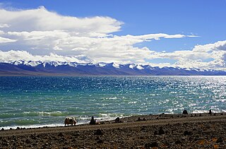
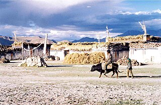
Damxung is a county of Lhasa City, lying to the north of its main center of Chengguan, in the Tibet Autonomous Region of the People's Republic of China. Its administrative seat is Damquka. The terrain is rugged, including the western Nyenchen Tanglha Mountains, with their highest peak rising to 7,111 metres (23,330 ft). As of 2013 the population was 40,000, with most of the people engaged in animal husbandry.

Nyêmo is a county in the Lhasa west of the main center of Chengguan, Tibet. It lies on the north bank of the Yarlung Tsangpo River, the northern part of the Brahmaputra. The county has an area of 3,276 square kilometres (1,265 sq mi), and as of 2011 had a population of 30,844 people, mostly engaged in agriculture or herding.

Qüxü County, or Qushui or Chushur or Chushul, is a county in the Lhasa southwest of the main center of Chengguan, Tibet, China. It is mountainous in the northwest, flatter near the Lhasa River, which runs through the east of the county, and the Yarlung Tsangpo, which forms the southern border. The population as of 2000 was 29,690, mostly engaged in agriculture or animal husbandry. The county is home to the Nyethang Drolma Lhakhang Temple.

Dagzê District is a district of Lhasa immediately east of the district of Chengguan, Tibet. The Lhasa River runs through the district. As of 2013 the total population was 29,152, mostly ethnic Tibetans engaged in agriculture. The district is home to the Ganden and Yerpa monasteries.

Maizhokunggar County or Meldro Gungkar County is a county of Lhasa and east of the main center of Chengguan, Tibet Autonomous Region. It has an area of 5,492 square kilometres (2,120 sq mi) with an average elevation of over 4,000 metres (13,000 ft). Most of the people are ethnic Tibetan and are engaged in agriculture or herding. Mining is a major source of tax revenue, but has created environmental problems. The county has various tourist attractions including hot springs and the Drigung Monastery.
Nagqu is a prefecture-level city in the Chinese Autonomous region of Tibet. The former Nagqu Prefecture ceased to be as a separated prefecture, the prefecture-level city of Nagqu was approved to establish by the State Council on October 2, 2017 and officially established on May 7, 2018. Nagqu is the sixth prefecture-level city in Tibet after Lhasa, Shigatse, Chamdo, Nyingchi and Shannan, and it is also the prefecture-level city with the highest altitude.

Pagri or Phari is a town in Yadong County in the Tibet Autonomous Region, China near the border with Bhutan. As of 2004 the town had a population of 2,121. It is one of the highest towns in the world, being about 4,300 m (14,100 ft) above sea-level at the head of the Chumbi Valley.

Seni District is a district within the Nagqu of the Tibet Autonomous Region, western People's Republic of China.
Amdo County is a county within Nagqu of the Tibet Autonomous Region of China. The county covers an area of 43,410.85 square kilometres and is dominated by mainly Tibetan grassland. In 2000 it had a population of 32,843.

Dunhua is a county-level city of the Yanbian Korean Autonomous Prefecture in southeastern Jilin province, People's Republic of China. It has more than 480,000 inhabitants and was the capital of Balhae between 742−756, known at the time as "Junggyeong". During the Qing Dynasty it was called Áodōng (敖东) in Chinese and Odoli in Manchu.

Sanga Monastery is a small Tibetan Buddhist monastery located in the town of Dagzê in Dagzê County, Lhasa, Tibet.
Tingri County or Dhringgri County, is a county under the administration of the prefecture-level city of Xigazê in the Tibet Autonomous Region of China.

Barma, or Pama, Pamaxiang, also spelled Parma or Jarma) is a small town and township-level division in Zhongba County in the Shigatse Prefecture of the Tibet Autonomous Region of China. It is located roughly 500 kilometres (310 mi) northwest of Lhasa next to Chabyer Co lake, north of Taro Co. The township was established in 1961 and covers an area of 4,098 square kilometres (1,582 sq mi).

Garzê County is one of the 18 subdivisions of the Garzê Tibetan Autonomous Prefecture, in northwestern Sichuan province, China. The Yalong River passes just south of the town Garzê, also known as Ganzi, the capital town of the county, which has some 16,920 inhabitants (2010), many of them ethnic Tibetans, and is famous for its Tibetan lamasery. Historically, it is part of the Tibetan cultural region of Kham and now defunct province of Xikang. It lies on the northern section of the Sichuan-Tibet Highway.

Pingtan County is a county comprising 126 islands in the Taiwan Strait, under the administration of Fuzhou, the capital of Fujian province, People's Republic of China. Now it is also the subject of newly founded Pingtan Comprehensive Pilot Zone (平潭综合实验区). The main island is Haitan Island.
Zhujia is a village in Lhünzhub County in the Lhasa Prefecture of Tibet Autonomous Region, in China. It lies 25.5 kilometres (15.8 mi) by road west of Lhünzhub, near Hutoushan Reservoir. By road it is 90 kilometres (56 mi) from Lhasa, but considerably nearer to the north as the road forks around much further to the east first before approaching Lhünzhub and Zhujia. It appears to have been a township of Lhünzhub County, covering 126 square kilometers, with a population of 4000 at one point, with 12 village committees. However, the National Bureau of Statistics now lists Zhujia as a village and no longer as an official township-level division of Lhünzhub County.

The Nimu Maqu River is a left tributary of the Yarlung Tsangpo River that flows south through Nyêmo County in Lhasa Municipality, Tibet, China.
Lhasa is a prefecture-level city, formerly a prefecture until 7 January 1960, one of the main administrative divisions of the Tibet Autonomous Region of China. It covers an area of 29,274 square kilometres (11,303 sq mi) of rugged and sparsely populated terrain. The consolidated prefecture-level city is divided into five mostly rural counties and three partially urban districts Chengguan District, Doilungdêqên District, and Dagzê District, which contain the main urban area of Lhasa.


