
Bærum is a municipality in the Greater Oslo Region in Akershus County, Norway. It forms an affluent suburb of Oslo on the west coast of the city. Bærum is Norway's fifth largest municipality with a population of 128,760 (2021). The administrative centre of the municipality is the town of Sandvika. Bærum was established as a municipality on 1 January 1838.
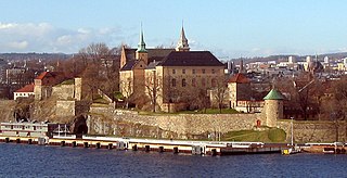
Akershus is a county in Norway, with Oslo as its administrative centre, although Oslo itself is not a part of Akershus. It is named after the Akershus Fortress in Oslo. From the middle ages to 1919, Akershus was a fief and main county that included most of Eastern Norway, and from the 17th century until 2020 and again from 2024, Akershus also has a more narrow meaning as a smaller central county in the Greater Oslo Region. In 2020, the county of Akershus was merged into Viken along with the counties of Østfold and Buskerud. In 2022, the Storting voted to dissolve Viken and reestablish Akershus county. Akershus was reestablished in 2024 with slightly altered borders now including the municipalities of Jevnaker and Lunner plus the former municipalities of Røyken and Hurum which merged with Asker in 2020.

Krødsherad is a municipality in Buskerud county, Norway. The administrative centre of the municipality is the village of Noresund. The municipality of Krødsherad was established when it was separated from the municipality of Sigdal on 1 January 1901.

Lier is a municipality in Buskerud county, Norway. The administrative centre of the municipality is the village of Lierbyen. The municipality of Lier was established on 1 January 1838. The area Åssiden was transferred from Lier to the neighboring municipality of Drammen on 1 July 1951.

Drøbak is a town and the centre of the municipality of Frogn, in Akershus county, Norway. The city is located along the Oslofjord, and has 13,409 inhabitants.
Hokksund is a town in the municipality of Øvre Eiker in the county of Viken, Norway.

Bernt Holtsmark was a Norwegian farmer and politician for the Conservative Party and the Liberal Left Party. He was a four-term member of the Parliament of Norway, and served as Minister of Agriculture from 1910 to 1912. He was also known for establishing the agricultural college at Sem in his native Asker.

Nærsnes is a village in Røyken in Asker municipality in Akershus, Norway. It is located along the Oslofjord between Båtstø and Slemmestad. As of 2003, it is considered a part of the Greater Oslo area.

The Asker Line is a 9.5-kilometre (5.9 mi) railway line between Asker and Lysaker in Norway. The line runs along the same corridor as the Drammen Line, offering increased capacity, speed and regularity on the rail network west of Oslo. The first part opened in 2005, and in 2011 an extension opened from Sandvika to Lysaker. Original plans called for an extension to Skøyen, but from 2020, new planning is under way for an extension all the way to Oslo Central Station. Most of the railway is in tunnel and is dimensioned for 160 km/h (99 mph) running. The entire railway is electrified at 15 kV 16.7 Hz AC. The first section cost 3.7 billion kr, while the second is budgeted at NOK 2.7 billion.

Lysaker Station is a railway station on the Drammen Line and Asker Line situated at Lysaker in Bærum, Norway. Located 7.00 kilometers (4.35 mi) from Oslo Central Station, Lysaker is served by a mix of Vy express, regional and Oslo Commuter Rail trains, as well as Flytoget. The station is elevated and features two island platforms with four tracks. It's the terminus of the Asker Line.

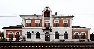
Sandvika Station is a railway station located at Sandvika in Bærum, Norway. Situated on the Drammen Line, 14.14 kilometers (8.79 mi) from Oslo S, it also an intermediate station of the Asker Line. Vy serves the station with local and regional, with about 7,000 passengers using the station daily. It is also served by the Airport Express Train and serves as the main bus terminal for the town. The station is elevated and has two island platforms and four tracks.

Slemmestad is a village in Røyken in Asker municipality in Akershus, Norway. Slemmestad is located on the west bank of the Oslofjord, west of Oslo.

Stabekk Station is a railway station of the Drammen Line situated at Stabekk in Bærum, Norway. Located 8.99 kilometers (5.59 mi) from Oslo Central Station, it is served by line L1, L2, L2x and L21 of the Oslo Commuter Rail and by Flytoget - the express train to Oslo Airport. It is located in a primarily residential area and has four regular hourly services operated by Vy. The station features an island platform accessible from the station building on the south side.

Hvalstad Station is a railway station of the Drammen Line located at Hvalstad in Asker, Norway. Situated 20.19 kilometers (12.55 mi) from Oslo Central Station, it consists of an island platform and serves the L1 line of the Oslo Commuter Rail operated by Vy. The station served 233,000 passengers in 2012.
Skallum is an area at Stabekk in Bærum, Norway. It was named after the historic estate Skallum. It is known locally for its art gallery and as a recreational area, and nationally as the site of an event in the closing days of World War II in Europe.
Øverland is an area in Bærum, Norway. Named after the local farm, Øverland is also known as a recreational area and for its arboretum. It has lent its name to the river Øverlandselva.

Grini is a district in northeastern Bærum, Norway.

Polhøgda is the home of the Fridtjof Nansen Institute. It was originally built as the private home of Norwegian explorer Fridtjof Nansen. The manor home's architecture is Roman Revival, and the former estate lies between Lysaker and Fornebu in Bærum, Norway.
Nadderud is a district in eastern Bærum, Norway. It was formerly farmland under one of Bærum's larger farms, named Nadderud, but since the 1950s it has been built up with housing, several schools and sporting facilities. The best known facility, which has made the name Nadderud nationally known, is the stadium Nadderud stadion. Parts of the district Nadderud have been absorbed by the growing suburban centre Bekkestua.

Frithjof Møinichen Plahte was a Norwegian merchant and landowner. After a career in the timber business, he settled in Bærum where he invested in business and in several farms. His family socialized within the upper echelon in the capital city region, and he stood behind the establishment of Høvik Church and the use of Fleskum farm by a group of painters.
