
The Ratak Chain is a chain of islands and atolls within the island nation of the Marshall Islands. Ratak means "sunrise". It lies to the east of the country's other island chain, the Ralik Chain. In 1999, the total population of the Ratak islands was 30,925.
The Maloelap Atoll is a coral atoll of 71 islands in the Pacific Ocean, and forms a legislative district of the Ratak Chain of the Marshall Islands. Its land area is only 9.8 square kilometers (3.8 sq mi), but that encloses a lagoon of 972 square kilometers (375 sq mi). It is located 18 kilometers (11 mi) north of the atoll of Aur. The population of the atoll was 395 at the 2021 census.
Russell Effaney Kun is a political figure from the Pacific nation of Nauru and former powerlifter.
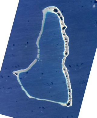
Ailuk Atoll is a coral atoll of 57 islets in the Pacific Ocean, and forms a legislative district of the Ratak Chain of the Marshall Islands. It is located approximately 72 kilometers (45 mi) north from Wotje. Its total land area is only 5.4 square kilometers (2.1 sq mi), but it encloses a lagoon with an area of 177.45 square kilometers (68.51 sq mi). The major islets are: Ajelep, Aliej, Ailuk, Alkilwe, Barorkan, Biken, Enejabrok, Enejelar, Kapen and Marib. Most of the islets are on the eastern side of the atoll. The western and southern sides of the atoll have a nearly continuous submerged coral reef, with three main passes that lead into the lagoon: Erappu Channel, Marok Channel and Eneneman Channel on the west side.
Aur Atoll is a coral atoll of 42 islands in the Pacific Ocean, and forms a legislative district of the Ratak Chain of the Marshall Islands. Its total land area is only 15 square kilometers (5.6 sq mi), but it encloses a lagoon with an area of 620 square kilometers (240 sq mi). It is located south of Maloelap Atoll. The population of Aur Atoll was 317 in 2021.

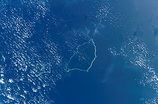
Likiep Atoll is a coral atoll of 65 islands in the Pacific Ocean, and forms a legislative district of the Ratak Chain of the Marshall Islands. It is approximately 55 kilometers (34 mi) northwest of Wotje. Its total land area is only 10.26 square kilometers (3.96 sq mi), but that encloses a deep central lagoon of 424 square kilometers (164 sq mi). Likiep Atoll also possesses the Marshall Islands' highest point, an unnamed knoll 10 meters (33 ft) above sea level. The population of Likiep Atoll was 228 in 2021.

Mejit is an island in the Pacific Ocean, and forms a legislative district of the Ratak Chain of the Marshall Islands. Unlike most of the other islands of the Marshall Islands, Mejit is a stony island rather than a coral atoll, although it is surrounded by a fringing coral reef enclosing a narrow lagoon. It is located east of the main line of the Ratak chain, approximately 110 kilometers (68 mi) northeast from Wotje. The population was 230 at the 2021 census.
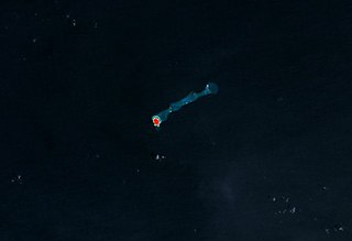
Jemo Island Atoll is an uninhabited coral island in the Pacific Ocean, in the Ratak Chain of the Marshall Islands north-east of Likiep Atoll. The island is oval-shaped and occupies the southwestern end of a narrow submarine ridge that extends to the northeast for several kilometers. Its total land area is only 0.16 square kilometers (0.062 sq mi). The island is traditionally held as a food reserve for the family of Joachim and Lijon deBrum, passed down to Lijon debrum from Iroijlaplap Lobareo and is owned by the current Likiep land-owning families of Joachim and Lijon debrum, grandkids of Iroijlaplap Jortõka of Ratak Eañ. There is also a shipwreck of unknown origin on the west side of the island.
Remios Hermios is one of two iroijlaplap of the Ratak Chain in the Marshall Islands. His traditional domain includes the atolls of Aur, Maloelap, Erikub, Wotje, Likiep, Ailuk, Utirik and Taongi; he and his predecessors have also laid claim to U.S.-administered Wake Island. The other paramount chief in the chain is incumbent president, Jurelang Zedkaia, whose domain covers Majuro, Arno and Mili atolls.

The following outline is provided as an overview of and topical guide to the Marshall Islands:

Kaven is a small island in the Maloelap Atoll in the Republic of the Marshall Islands. Situated at the northwesternmost tip of the atoll, it is the largest island and one of the few inhabited ones on the atoll. Together with a few other small islands, it forms part of the "outer islands" of the Marshalls. The island is located to the east of the Likiep Atoll, between Jeltonet in the southwest and Anejaej in the northwest. The southwesternmost tip of the island is called Anenemmwaan also. The region is uninhabited.

The following is an alphabetical list of topics related to the Marshall Islands.
Aquaculture in the Marshall Islands is governed by the Marshall Islands Marine Resources Authority. A hatchery for giant clams has been established by the national government in Likiep Atoll, and at least one other clam farm is in operation in Mili Atoll. At the CSD-16 Partnerships Fair in 2008, Erik Hagberg suggested that Holothuroidea cultivation is a viable option for developing aquaculture in the country.
Agony Island is an island in the Marshall Islands. It is one of the many islands that surround the Likiep Atoll lagoon on the southern edge.
Constitutional Convention elections were held in the Marshall Islands in November 1976.
The Joachim DeBrum House, known simply as the DeBrum House and also spelled Debrum House or De Brum House, located on Likiep Island, of Likiep Atoll, in the Marshall Islands, is a plantation house that was built in 1888 by Joachim DeBrum. It was listed on the United States National Register of Historic Places in 1976, making it the first NRHP site in Micronesia.

Tony deBrum was a Marshallese politician and government minister. His cabinet posts included Minister in Assistance to the President of Marshall Islands, Minister of Finance, Minister of Foreign Affairs and Minister of Education.

Republic of Marshall Islands Public School System (PSS) is the public school system of the Marshall Islands, headquartered in Majuro. It was established in November 2013 by Public Law 2013-23.
Northern Islands High School (NIHS) is a secondary school in Wotje, Marshall Islands. It is a part of the Marshall Islands Public School System.
