
Lake Michigan is one of the five Great Lakes of North America. It is the second-largest of the Great Lakes by volume and the third-largest by surface area, after Lake Superior and Lake Huron. To the east, its basin is conjoined with that of Lake Huron through the 3+1⁄2-mile (5.6-kilometer) wide, 295-foot deep Straits of Mackinac, giving it the same surface elevation as its easterly counterpart; geologically, the two bodies are a single lake.

Leelanau County is a county located in the U.S. state of Michigan. As of the 2020 census, the population was 22,301. Since 2008, the county seat has been located within Suttons Bay Township, one mile east of the unincorporated village of Lake Leelanau. Before 2008, Leelanau County's seat was Leland. Leelanau County is included in the Traverse City metropolitan area of Northern Michigan. The largest settlement in Leelanau County by population is Greilickville, itself a suburb of Traverse City.
Benzie County is a county in the U.S. state of Michigan. As of the 2020 census, the population was 17,970. The county seat is Beulah. The county was initially set off in 1863 and organized in 1869. At 321 square miles (830 km2), Benzie County is the smallest of the 83 counties in Michigan in terms of land area.

Cleveland Township is a civil township of Leelanau County in the U.S. state of Michigan. The population of Cleveland Township was 1,103 at the 2020 census. Part of the township is located within Sleeping Bear Dunes National Lakeshore.

Indiana Dunes National Park is a United States national park located in northwestern Indiana managed by the National Park Service. It was authorized by Congress in 1966 as the Indiana Dunes National Lakeshore and was redesignated as the nation's 61st national park on February 15, 2019. The park runs for about 20 miles (32 km) along the southern shore of Lake Michigan and covers 15,349 acres (6,212 ha). Along the lakefront, the eastern area is roughly the lake shore south to U.S. 12 or U.S. 20 between Michigan City, Indiana, on the east and the Cleveland-Cliffs steel plant on the west. This area's conservation scheme is enhanced by the older Indiana Dunes State Park. To the west of the steel plant lies West Beach and a small extension south of the steel mill continues west along Salt Creek to Indiana 249. The western area is roughly the shoreline south to U.S. 12 between the Burns Ditch west to Broadway in downtown Gary, Indiana. In addition, there are several outlying areas, including Pinhook Bog, in LaPorte County to the east; the Heron Rookery in Porter County, the center of the park; and the Calumet Prairie State Nature Preserve and the Hobart Prairie Grove, both in Lake County, the western end of the park.

Sleeping Bear Dunes National Lakeshore is a U.S. national lakeshore in the northwestern Lower Peninsula of Michigan. Located within Benzie and Leelanau counties, the park extends along a 35-mile (56 km) stretch of Lake Michigan's eastern coastline, as well as North and South Manitou islands, preserving a total of 71,199 acres. The park is known for its outstanding natural features, including dune formations, forests, beaches, and ancient glacial phenomena. The lakeshore also contains many cultural features, including the 1871 South Manitou Island Lighthouse, three former stations of the Coast Guard, and an extensive rural historic farm district.

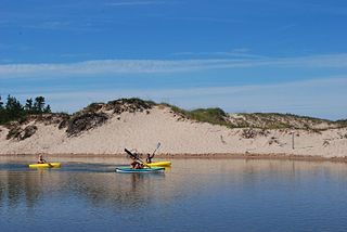
South Manitou Island is located in Lake Michigan, approximately 16 miles (26 km) west of Leland, Michigan. It is part of Leelanau County and the Sleeping Bear Dunes National Lakeshore. The uninhabited island is 8.277 sq mi (21.44 km2) in land area and can be accessed by a ferry service from Leland. Guided tours on open-air vehicles are available to visitors, but most traffic is on foot. Larger North Manitou Island lies to its north.
The Leelanau Peninsula is a peninsula of the U.S. state of Michigan that extends about 30 miles (50 km) from the western side of the Lower Peninsula of Michigan into Lake Michigan, forming Grand Traverse Bay. It is often referred to as the "little finger" of the mitten-shaped lower peninsula. The peninsula is a tourist hotspot, especially due to the popularity of Sleeping Bear Dunes National Lakeshore, which adorns the southwestern coast of the peninsula. The peninsula is also largely agricultural, and is a production hotspot for cherries and wine.

M-22 is a state trunkline highway in the US state of Michigan. It is 116.7 miles (187.8 km) long and follows the Lake Michigan shoreline of the Leelanau Peninsula, making up a portion of the Lake Michigan Circle Tour. It also passes through the Sleeping Bear Dunes National Lakeshore. The highway is U-shaped as it rounds the peninsula running through tourist areas in Leland and Suttons Bay in addition to the national lakeshore.

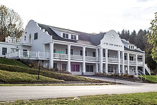
Leland is an unincorporated community and census-designated place (CDP) in the U.S. state of Michigan. It is located in Leelanau County, part of the northwestern Lower Peninsula of the state. As of the 2020 census it had a population of 410. From 1883 to 2004, Leland was the county seat of Leelanau County, which has since moved to Suttons Bay Township.

Northern Michigan, also known as Northern Lower Michigan, is a region of the U.S. state of Michigan. A popular tourist destination, it is home to several small- to medium-sized cities, extensive state and national forests, lakes and rivers, and a large portion of Great Lakes shoreline. The region has a significant seasonal population much like other regions that depend on tourism as their main industry. Northern Lower Michigan is distinct from the more northerly Upper Peninsula and Isle Royale, which are also located in "northern" Michigan. In the northernmost 21 counties in the Lower Peninsula of Michigan, the total population of the region is 506,658 people.

Grand Traverse Bay is an arm of Lake Michigan, located along the west coast of the Lower Peninsula of Michigan. The bay is separated from the rest of Lake Michigan by the Leelanau Peninsula. The bay is some 32 miles (51 km) long, ranges from 7 to 10 miles wide, and up to 620 feet (190 m) deep in spots. It is the second-largest bay of Lake Michigan, behind Green Bay.

Peshawbestown is an unincorporated community in Suttons Bay Township of Leelanau in the U.S. state of Michigan. In historical documents, the name is spelled variously as Peshabetown, Peshabatown, Pshawbatown, Preshabestown.
The Platte River is a 29.5-mile-long (47.5 km) river in the northwestern Lower Peninsula of Michigan. Beginning at Long Lake in Grand Traverse County, the Platte River flows west across Benzie County before ending at Platte Bay, a small bay of Lake Michigan, in the Sleeping Bear Dunes National Lakeshore. The river drains an area of about 193 square miles (500 km2).

Glen Lake is a lake located in Northern Michigan. Located in the southwestern Leelanau Peninsula, the lake is directly adjacent to Sleeping Bear Dunes National Lakeshore, and is, at its closest, about 0.94 miles (1.51 km) from Lake Michigan. The lake consists of two large bodies of water connected by a narrow channel, which is traversed by a causeway carrying the famous highway M-22. The body of water on the west of this causeway, which is far shallower and more elongated, is known as Little Glen Lake, and the body of water east of the causeway, which is nearly perfectly round and deeper, is known as Big Glen Lake.
The Fox Islands consist of the North Fox and South Fox Islands, in Lake Michigan. The uninhabited islands are approximately 17 miles (27 km) northwest of Cathead Point near the tip of the Leelanau Peninsula of Michigan and about 10 miles (16 km) southwest of Beaver Island. The two islands form part of an archipelago. South Fox Island Light was built in 1867 and operated until 1959. Both islands are part of Leelanau County, Michigan, and are administered by Leelanau Township. Several shipwrecks have occurred on the Fox Islands, or the reefs adjoining them; in 1851, the Illinois was reported as a "total wreck" on the Fox Island reef, In 1860, the bark Fontanelle ran aground at the Fox Islands, and in 1861, the schooner Nightingale. In 1873, the ships Frank Perew and Magnet encountered trouble at the Fox Islands.
Lake Leelanau is an unincorporated community and census-designated place (CDP) in Leelanau County, Michigan, near the lake of the same name. As of the 2020 census it had a population of 229. It is situated along M-204 at the "narrows" that separate North and South Lake Leelanau. The community is divided between Leland Township and Suttons Bay Township.

Glen Haven is a restored port village on the shore of Lake Michigan on the Leelanau Peninsula within the now Sleeping Bear Dunes National Lakeshore. Attractions include the Lake Michigan beach, a restored General Store and Blacksmith Shop. The unincorporated community is located in Glen Arbor Township.

The Pierce Stocking Scenic Drive is a scenic route within Sleeping Bear Dunes National Lakeshore, in western Northern Michigan in the United States. The roadway, with its "scenic vistas and gentle curves", is located off state highway M-109 between Empire and Glen Arbor. It runs for 7.4 miles (11.9 km) through forest and dunes areas, providing access to scenic overlooks of the Lake Michigan shoreline and the surrounding park land. Interpretive markers along the roadway are keyed to the National Park Service's printed guide to the drive. Over 80,000 vehicles make the trip, in addition to bicyclists, hikers and skiers who use the road each year.

Trail Creek is a 7.3-mile-long (11.7 km) north- by northwest-flowing stream whose main stem begins at the confluence of the West Branch Trail Creek and the East Branch Trail Creek in LaPorte County, Indiana, United States. Its mouth is a Lake Michigan harbor and marina adjacent to Washington Park in Michigan City, Indiana.

