
The Irvine Company LLC is an American private company focused on real estate development. It is headquartered in Newport Beach, California, with a large portion of its operations centered in and around Irvine, California, a planned city of more than 300,000 people mainly designed by the Irvine Company. The company was founded by the Irvine family and is currently wholly owned by Donald Bren.
Modjeska Canyon is an unincorporated community and census designated place (CDP) on the western slope of the Santa Ana Mountains in eastern Orange County, California. It is a suburban community of several hundred residents, with a small park and a volunteer fire station. The ZIP Code is 92676, and the community is inside area code 714.

Jamboree Road is a 15.8-mile (25.4 km) long major arterial road through Orange County, California, running through the cities of Newport Beach, Irvine, Tustin, and Orange.

Irvine Lake is a reservoir in Orange County, California, United States. It is on Santiago Creek, located in Silverado, California, east of the city of Irvine and close to Irvine Regional Park. The reservoir is currently operated by the Serrano Water District and OC Parks.

Aliso Creek is a 19.8-mile (31.9 km)-long, mostly urban stream in south Orange County, California. Originating in the Cleveland National Forest in the Santa Ana Mountains, it flows generally southwest and empties into the Pacific Ocean at Laguna Beach. The creek's watershed drains 34.9 square miles (90 km2), and it is joined by seven main tributaries. As of 2018, the watershed had a population of 144,000 divided among seven incorporated cities.

Santiago Creek is a major watercourse in Orange County in the U.S. state of California. About 34 miles (55 km) long, it drains most of the northern Santa Ana Mountains and is a tributary to the Santa Ana River. It is one of the longest watercourses entirely within the county. The creek shares its name with Santiago Peak, at 5,687 ft (1,733 m) the highest point in Orange County, on whose slopes its headwaters rise.

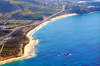
Laguna Canyon, also called Cañada de las Lagunas, is a gorge that cuts through the San Joaquin Hills in southern Orange County, California, in the United States, directly south of the city of Irvine. The canyon runs from northeast to southwest, and is drained on the north side by tributaries of San Diego Creek and on the south by Laguna Canyon Creek. It is deeper and more rugged on the southwestern end near Laguna Beach.

Sulphur Creek is an approximately 4.5-mile (7.2 km) tributary of Aliso Creek in Orange County, California. The creek drains about 6 square miles (16 km2) in the suburban cities of Laguna Niguel and Laguna Hills. Although most of its watershed has been utilized for master planned residential development, the creek retains a natural channel with riparian and wetland habitat in parts of Laguna Niguel Regional Park and Aliso and Wood Canyons Regional Park. Urban runoff has changed the once seasonal creek into a perennial stream.

Laguna Coast Wilderness Park is a 7,000-acre (2,800 ha) wilderness area in the San Joaquin Hills surrounding Laguna Beach, California. This park features coastal canyons, ridgeline views and the only natural lakes in Orange County, California. Trails are maintained for hiking and mountain biking with a wide range of difficulty, from beginner to expert. Most trails gain in height, reaching a maximum of 1,000 feet (300 m) in elevation. Several trails lead to downtown Laguna Beach.
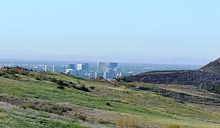
The Frank R. Bowerman Landfill is a landfill in the western Santa Ana Mountains, in Orange County, California. It opened in 1990 and is located between Limestone Canyon Regional Park and State Route 241.
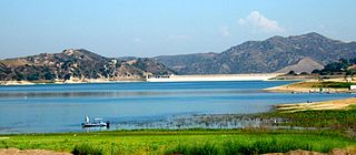
Santiago Dam is an earth/rockfill dam across Santiago Creek in Orange County, in the U.S. state of California, forming Irvine Lake. The 136-foot (41 m) earth dam and its reservoir serve for flood control and recreational purposes. It lies upstream (southeast) from the city of Orange and north of Irvine. Irvine Lake is the largest body of fresh water entirely in Orange County.
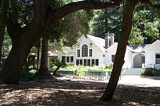
Bommer Canyon is an open space preserve in southern Irvine, California featuring hiking and biking trails as well as private event areas. The canyon is part of the Irvine Ranch, which itself is a National Natural Landmark, the first California Natural Landmark, and part of the City of Irvine Open Space Preserve. The preserve is adjacent to the affluent Irvine villages of Shady Canyon and Turtle Ridge and features roughly 16,000 acres of preserved open space. Approximately 15 of these acres are preserved as a "Cattle Camp" named for the area's previous cattle operations and are now rented for private events such as campouts, company picnics, and family reunions. The trails in Bommer Canyon feature groves of oak and sycamore trees as well as rough rock outcrops and are popular with area residents who use them for nature walks, hiking and mountain biking.

Peters Canyon Regional Park is a regional park within the Orange County Regional Parks System in California. The park contains 354 acres of southern California wildlife, including coastal sage shrub, riparian, freshwater marsh, and grasslands, and is located within the boundaries of both Orange, California and Tustin, California. Peters Canyon was given to this city in 1992 by the Irvine Company who had used it previously for cattle grazing. The canyon is lined with a residential area on one side and open hills on the other. This canyon is commonly used by hikers, mountain bikers, and equestrians because of the trails that circumvent the 50 acre man-made lake, which was constructed by the Irvine Company in 1931, on the interior of the plot. The regional park is open from 7:00 AM to sunset every day of the week, save for the chance of rain or hazardous conditions, in which case the park will be closed for three days following the particular occurrence.
The Irvine Ranch Natural Landmarks are a collection of protected areas in Orange County, California in and around Irvine. They encompass almost 50,000 acres (20,000 ha) of land which was once a part of the Irvine Ranch owned by the Irvine Company. Almost 40,000 acres (16,000 ha) of the landmarks were designated a National Natural Landmark in 2006 and a California Natural Landmark in 2008.
Agua Chinon Creek or Agua Chinon Wash is an urban stream in the city of Irvine, Orange County, California. The creek flows southwest from its headwaters in the foothills of the Santa Ana Mountains for about 8 miles (13 km) to join San Diego Creek near the Verizon Amphitheatre. The creek drains a total watershed area of 7,049 acres (2,853 ha).

Carbon Canyon Regional Park is a regional park in Brea, California, that was created after the Carbon Canyon Creek was dammed. It links up with Chino Hills State Park on the east side. The park also is home to a small forest of Redwood trees, which have been struggling to survive since the start of the 2010 California drought.
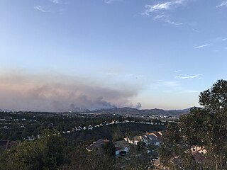
The Silverado Fire was a wildfire that burned in October and November 2020 in southern Orange County, California northeast of Irvine. The fire started on October 26 around 6:47 AM near Orange County Route S-18 and Silverado Canyon Road, fueled by strong Santa Ana winds gusting up to 80 miles per hour (130 km/h) and low humidity. Orange County Fire Authority Chief Brian Fennessy stated, "The winds were extraordinary even by Santa Ana standards. Fire spread is exceeding more than anything I've seen in my 44 years." The fire initially moved south from Loma Ridge toward the Orchard Hills, Northwood and Portola Springs communities of Irvine before moving southeast through Limestone Canyon and toward the communities of Foothill Ranch and Lake Forest. The fire burned in a path similar to that taken by the 2007 Santiago Fire, mostly through terrain that had not seen significant burning in the 13 years since that fire. 100% containment was announced on November 7, 2020.

The Bond Fire was a wildfire that burned 6,686 acres (2,706 ha) in the Santiago Canyon area of Orange County, California in December 2020. The fire caused evacuations of 25,000 residents and injured 2 firefighters. The fire was very close to the burn scar of the Silverado Fire, which took place in October 2020.

Whiting Ranch Wilderness Park is a 2,500 acre public regional park within the city of Lake Forest in southern Orange County, California. Whiting Ranch features riparian, oak woodland, grassland, chaparral, and coastal sage scrub environments throughout various canyons and hillscapes. The park is home to over 17 miles of trail spread out over 23 different paths, making the location a popular destination for mountain bikers, hikers, and horseback riders.
Orange County Parks, more commonly abbreviated to OC Parks, is a government agency that maintains and oversees the public parks of Orange County, California. OC Parks is responsible for 60,000 acres (24,000 ha) of inland and coastal open space that collectively receives millions of visitors every year.

