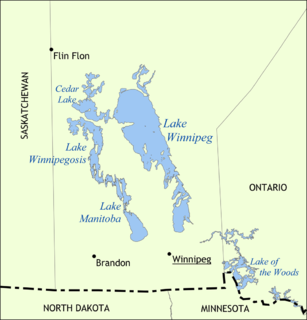
Lake Winnipeg is a very large, but relatively shallow 24,514-square-kilometre (9,465 sq mi) lake in North America, in the province of Manitoba, Canada. Its southern end is about 55 kilometres (34 mi) north of the city of Winnipeg. It is the largest lake within southern Canada's borders, and is part of the most undeveloped large watershed of southern Canada.

The Nelson River is a river of north-central North America, in the Canadian province of Manitoba. The river drains Lake Winnipeg and runs 644 kilometres (400 mi) before it ends in Hudson Bay. Its full length is 2,575 kilometres (1,600 mi), it has mean discharge of 2,370 cubic metres per second (84,000 cu ft/s), and has a drainage basin of 1,072,300 square kilometres (414,000 sq mi), of which 180,000 square kilometres (69,000 sq mi) is in the United States.

An alvar is a biological environment based on a limestone plain with thin or no soil and, as a result, sparse grassland vegetation. Often flooded in the spring, and affected by drought in midsummer, alvars support a distinctive group of prairie-like plants. Most alvars occur either in northern Europe or around the Great Lakes in North America. This stressed habitat supports a community of rare plants and animals, including species more commonly found on prairie grasslands. Lichen and mosses are common species. Trees and bushes are absent or severely stunted.
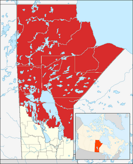
Northern Manitoba is the most northerly region of the Canadian province of Manitoba, added to the province during the last major expansion of its boundaries in 1912. Forestry, mining and hydro-electric development are significant economic drivers with long-term consequences to the environment in the region.

Gillam is a town on the Nelson River in northern Manitoba, Canada. It is situated between Thompson and Churchill on the Hudson Bay Railway line. Many residents of Gillam are employed by Manitoba Hydro at three of Manitoba's largest hydro dams—Kettle Generating Station, Long Spruce Generating Station, and Limestone Generating Station— located within Gillam's boundaries.
The Rural Municipality of Alexander is a rural municipality in the Eastern region of Manitoba, Canada. The office is located in St. Georges, Manitoba. The town of Powerview-Pine Falls lies adjacent to the municipality, as does the Sagkeeng First Nation Indian reserve. The Chevrefils District and Broadlands are located in the R.M.

The Gods River is a remote wilderness river in the Hudson Bay drainage basin in Northern Manitoba, Canada. Its flows from its source at Gods Lake to its mouth at the Hayes River. The Hayes River flows to Hudson Bay.
The Sturgeon River is a river in the Hudson Bay drainage basin in Manitoba and Ontario, Canada. It flows west from its source in Unorganized Kenora District, Northwestern Ontario, through Sturgeon Lake, and takes in the right tributary Hayhurst River just before reaching its mouth at the Echoing River in Northern Region, Manitoba. The Echoing River flows via the Gods River and the Hayes River to Hudson Bay.
The Bolton River is a river in the Hudson Bay drainage basin in Census Division No. 22 - Thompson-North Central, Northern Region, Manitoba, Canada. It is about 115 kilometres (71 mi) long and begins at Musketasonan Lake, about 20 kilometres (12 mi) south of Molson Lake, at an elevation of 249 metres (817 ft). It flows northeast through Little Bolton Lake at an elevation of 224 metres (735 ft), Rushforth Lake at an elevation of 218 metres (715 ft), Bolton Lake at an elevation of 212 metres (696 ft), where it takes in the right tributary Nikik River, and Kakwusis Lake at an elevation of 208 metres (682 ft). The river continues northeast over the twin Kasukwapiskechewak Rapids, then over the twin Kakwu Rapids, and empties into Aswapiswanan Lake at an elevation of 186 metres (610 ft), about 60 kilometres (37 mi) west southwest of the community of Gods Lake Narrows. The Bolton River's waters eventually flow into Gods Lake, and via the Gods River and the Hayes River into Hudson Bay.
The Echoing River is a river in the Hudson Bay drainage basin in Manitoba and Ontario, Canada. Its flows from its source at Echoing Lake in Unorganized part of Kenora District, Northwestern Ontario to its mouth at the Gods River in Northern Manitoba. The Gods River flows via the Hayes River to Hudson Bay.
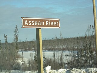
Assean River is a river in the Hudson Bay drainage basin in Northern Manitoba, Canada. Its flows from its source at Little Assean Lake to Clark Lake on the Nelson River.
Limestone Lake is a lake in Northern Manitoba, Canada. It is in the Hudson Bay drainage basin and is the source of the Limestone River.
The Little Churchill River is a river in the Hudson Bay drainage basin in Northern Manitoba, Canada. It flows from Waskaiowaka Lake to the Churchill River.
The Weir River is a river in the Hudson Bay drainage basin in Census division 23 in Northern Manitoba, Canada. Its flows from Weir Lake to the Nelson River as a left tributary, 70 kilometres (43 mi) upstream of that river's mouth at Hudson Bay.
Silcox Creek is a river in the Hudson Bay drainage basin in Census division 23 in Northern Manitoba, Canada. Its flows from David Wilson Lake to the Owl River as a right tributary. The Owl River flows to Hudson Bay.
The Owl River is a river in the Hudson Bay drainage basin in Census division 23 in Northern Manitoba, Canada. It flows from Fly Lake to Hudson Bay.
The Broad River is a river in the Hudson Bay drainage basin in Census division 23 in Northern Manitoba, Canada. Its flows from an unnamed lake to Hudson Bay.
The Black Duck River is a river in the provinces of Manitoba and Ontario, Canada. Flowing northeast from Hosea Lake in Kenora District in Northwestern Ontario, the river criss-crosses the Manitoba-Ontario border before reaching to its mouth at Hudson Bay in the Northern Region of Manitoba just west of Manitoba's easternmost point where the inter-provincial border meets the bay.

Southern Indian Lake is a large lake in Manitoba, Canada. It has an area of 2,247 km2 (868 sq mi) with a surface elevation of 258 m (846 ft).

Stephens Lake is a reservoir in the province of Manitoba in Canada north of Lake Winnipeg. The reservoir was created in 1971 by the Kettle Dam and received its official name of Stephens Lake in 1972. The lake is 32 km long from the inflow of the Nelson River to the outflow at the Kettle Dam. The lake is located 45 km northeast of Split Lake and 150 km west of the Hudson Bay.


