Councils of Tasmania are the 29 administrative districts of the Australian state of Tasmania. Local government areas (LGAs), more generally known as councils, are the tier of government responsible for the management of local duties such as road maintenance, town planning and waste management.

Launceston is a city in the north of Tasmania, Australia, at the junction of the North Esk and South Esk rivers where they become the Tamar River (Kanamaluka). Launceston is the second largest city in Tasmania after Hobart and the thirteenth-largest non-capital city in Australia.
The history of Tasmania begins at the end of the most recent ice age when it is believed that the island was joined to the Australian mainland. Little is known of the human history of the island until the British colonisation in the 19th century.
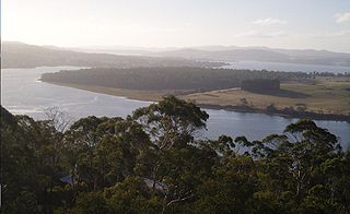
The Tamar River/kanamaluka is a 70-kilometre (43-mile) estuary located in northern Tasmania, Australia. Despite being called a river, the waterway is a brackish and tidal estuary over its entire length.

The University of Tasmania (UTAS) is a public research university primarily located in Tasmania, Australia. Founded in 1890, it is Australia's fourth oldest university. Christ College, one of the university's residential colleges, was founded in 1846 and is the oldest tertiary institution in the country. The University of Tasmania is a sandstone university and is a member of the international Association of Commonwealth Universities and the Association of Southeast Asian Institutions of Higher Learning.

The Midland Highway is one of Tasmania's major inter-city highways, running for 176 kilometres (109 mi) between Hobart and Launceston. It is part of the AusLink National Network and is a vital link for road freight to transport goods to and from the two cities. It represents a major north–south transportation corridor in Tasmania and has the route 1 designation as part of the National Highway. The highway consists of various traffic lane arrangements, the most common being two lanes – one in each direction, with overtaking options and at-grade intersections. At both the Launceston and Hobart sections of the highway there are small portions of grade-separated dual carriageway.

Longford is a town in the northern midlands of Tasmania, Australia. It lies 145 m above sea level at the convergence of the Macquarie River and the South Esk River, 21 km south of Launceston and a 15-minute drive from the airport. It is just south of the Illawarra Road, a road connecting the Bass and Midland Highways. It has a population of 3,863 and is part of the Northern Midlands Council area. The region is predominantly agricultural, noted for wool, dairy produce and stock breeding.

Launceston Airport is a regional airport on the outskirts of Launceston, Tasmania. The airport is located in the rural area of Western Junction 15 km (9.3 mi) from Launceston city centre. It is Tasmania's fastest growing airport, and the second busiest in the state, after Hobart International Airport; it can also run as a curfew free airport. In the 2007/2008 financial year, the airport had a record 1.1 million passengers, up 10% on the previous year; 255,000 passengers passed through the airport in the three months to 30 September, up 7% on the previous year. 309,000 passengers passed through in January – March 2008, the highest ever number in a calendar quarter, up 11% on the previous year. It is currently Australia's 13th busiest airport, handling 1,126,572 passengers in the 2008–09 financial and 1,124,000 passengers in the 2009–10 financial year. The total number of passenger movements through Launceston Airport is projected to increase annually by 2.7 per cent during the forecast period to 2,000,000 in 2030–31. The expected growth rate reflects slower forecast longer term economic growth in Australia, the maturation of the impact of low-cost carriers on passenger movement growth and an expected increase in domestic airfares.

The topsail schooner, Enterprize, was built in Hobart, Tasmania in 1830 by William Pender. It was used for coastal transport of cargo such as coal, livestock, and supplies.

Launceston Church Grammar School is an Anglican co-educational private school in Launceston, Tasmania, Australia for Early Learning through to Grade 12.
The mines of the West Coast of Tasmania have a rich historical heritage as well as an important mineralogical value in containing or having had found, specimens of rare and unusual minerals. Also, the various mining fields have important roles in the understanding of the mineralization of the Mount Read Volcanics, and the occurrence of economic minerals.
TheMercury is a daily newspaper, published in Hobart, Tasmania, Australia, by Davies Brothers Pty Ltd, part of News Corp Australia and News Corp. The weekend issues of the paper are called Mercury on Saturday and Sunday Tasmanian. The current editor of TheMercury is Chris Jones.

Launceston Christian School (Inc.) is a private, co-educational day school based in Riverside, Launceston, Tasmania, Australia. Established in 1976, the school is operated and controlled by an Association. Launceston Christian School caters for around 630 students from Kindergarten through to Year 12. The principal is Adrian Bosker.
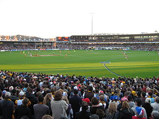
Australian rules football in Tasmania known as "football" officially and locally, has a history dating back to the 1860s, with the state having the distinction of being the first place outside Victoria to play the sport.
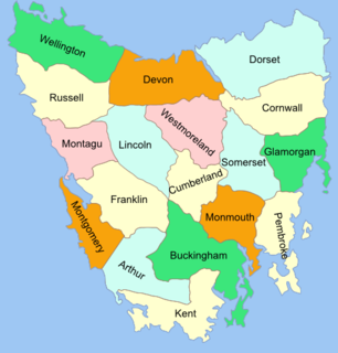
The Lands administrative divisions of Tasmania are the divisions of Tasmania into land districts and parishes for cadastral purposes, which are part of the lands administrative divisions of Australia. There are 20 land districts in Tasmania, although in the early nineteenth century there were several other systems, with 18 or 36 counties and 9 other divisions used, as well as hundreds. The land districts include the 18 former counties of the island of Tasmania which were renamed but retain the same boundaries, plus King Island and Flinders Island. The counties are referenced in the 1911 Encyclopædia Britannica, with Hobart described as being in Buckingham County, Launceston in Cornwall County and Beaconsfield in Devon County. The land districts are used for land titles today, while the Local Government Areas of Tasmania with cities and municipalities are used for political and administrative purposes.

SS City of Launceston was a 368 GRT steamship operated by the Launceston and Melbourne Steam Navigation Company from 1863, which had an early role in colonial steam shipping as the forerunner of the modern Bass Strait ferry service between Tasmania and Victoria. It was sunk in Port Phillip Bay after a collision with another ship on 19 November 1865.
James Archibald "Snowy" Atkinson was an Australian rules footballer and first class cricketer.
Launceston Leisure and Aquatic Centre is a double storey structure built at the old Windmill Hill Swimming Pool site in Launceston, Tasmania. The centre was opened on 25 May 2009, at a cost of A$26.3 million. The Launceston City Council estimates that 400,000 people would visit each year after the establishment period.
This is a list of members of the Tasmanian House of Assembly between the 1900 election and the 1903 election.
This is a list of members of the Tasmanian Legislative Council between 1885 and 1891. Terms of the Legislative Council did not coincide with Legislative Assembly elections, and members served six-year terms, with a number of members facing election each year.


