Lindy, Nebraska

Last updated

Lindy, Nebraska
Lindy, Nebraska downtown.JPG
Downtown Lindy; at left is the Lindy Country Club
USA Nebraska location map.svg
Red pog.svg
Lindy
Usa edcp location map.svg
Red pog.svg
Lindy
Coordinates: 42°44′03″N97°44′24″W / 42.73417°N 97.74000°W / 42.73417; -97.74000
Country United States
State Nebraska
County Knox
Townsite surveyed1928
Area
[1]
  Total1.00 sq mi (2.59 km2)
  Land1.00 sq mi (2.59 km2)
  Water0.00 sq mi (0.00 km2)
Elevation
[2]
1,611 ft (491 m)
Population
 (2020)
  Total13
  Density13.03/sq mi (5.03/km2)
Time zone UTC-6 (Central (CST))
  Summer (DST) UTC-5 (CDT)
ZIP code
68718
Area code 402
FIPS code 31-28140
GNIS feature ID2583888 [2]

Lindy is an unincorporated community and census-designated place located on the Santee Sioux Reservation in Knox County, in the northeastern part of the state of Nebraska in the Midwestern United States. As of the 2010 census it had a population of 13. [3]

Contents

Geography

Lindy is in northeastern Knox County, 7 miles (11 km) south of the Missouri River and the South Dakota border. Nebraska Highway 12 forms the southern edge of the community; the highway leads east 12 miles (19 km) to Crofton and west 15 miles (24 km) to Niobrara.

According to the U.S. Census Bureau, the Lindy CDP has an area of 1.00 square mile (2.59 km2), all land. [3] The community is in the valley of Hoboe Creek, a southwest-flowing tributary of Howe Creek, which in turn flows west to Bazile Creek, a north-flowing tributary of the Missouri River.

Demographics

Historical population
CensusPop.Note
2020 13
U.S. Decennial Census [4]

History

Lindy was established late in the state's history. The townsite was surveyed in 1928, in response to demand for a local marketing and shopping center. [5] Development was further encouraged by a rumor, which later proved unfounded, suggesting that a railroad line might be built through the area. [6] The new town was named after Charles Lindbergh, nicknamed "Lucky Lindy", who the year before had made his celebrated non-stop solo flight from New York to Paris. [5]

During its heyday, Lindy had a number of businesses, including a hardware store, a barbershop, an ice-cream parlor, a blacksmith shop, and an electrical-appliances shop. [5] It also boasted a large hall with a full basement for a garage, a dance hall and movie theater on the second floor, and office and living space on the third. This building was dismantled in 1944. [6] From 1944 to 1958, the local Addison Telephone Company operated out of Lindy. [5]

In later years, Lindy's population declined and its businesses closed. In 1978, it had a population of 38. In the late 1980s and early 1990s, the town's feed store, general store, and gas pumps were shut down or moved away. By 2002, there were 13 residents. [5]
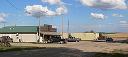
Lindy today

Lindy is an unincorporated community. [7] It is home to one commercial enterprise, the Lindy Country Club restaurant and bar; [8] to a single church, the Good Shepherd Evangelical Lutheran Church; [9] [10] and to a fire hall, operated by the Bloomfield Volunteer Fire Department and Rescue Unit. [5]

Lindy is located on Nebraska Highway 12. [11] It is within the Santee Sioux Reservation. [12]

In 2001, a number of northeastern Nebraska communities formed Shannon Trail Promoters, with the goal of increasing tourism in the forthcoming bicentennial year of the Lewis and Clark Expedition. The organization commissioned thirteen wooden chainsaw sculptures of Private George Shannon, a member of the expedition who became separated from the group in August 1804 and wandered lost for 16 days before rediscovering the party. These statues were placed in participating communities along a 240-mile (390 km) Shannon Trail. Sixteen wayside markers recounting aspects of Shannon's career were also installed along the trail, which runs through the region in which Shannon is thought to have traveled while trying to find and rejoin the expedition. A statue and a marker were placed in Lindy, beside the country club. [13] [14]

Related Research Articles

<span class="mw-page-title-main">Effigy Mounds National Monument</span> National monument of prehistoric mounds built by Native Americans, in Iowa, United States

Effigy Mounds National Monument preserves more than 200 prehistoric mounds built by pre-Columbian Mound Builder cultures, mostly in the first millennium CE, during the later part of the Woodland period of pre-Columbian North America. Numerous effigy mounds are shaped like animals, including bears and birds.

<span class="mw-page-title-main">Knox County, Nebraska</span> County in Nebraska, United States

Knox County is a county in the U.S. state of Nebraska. As of the 2020 United States Census, the population was 8,391. Its county seat is Center. Knox County was named for Continental and U.S. Army Major General Henry Knox.

<span class="mw-page-title-main">Box Butte County, Nebraska</span> County in Nebraska, United States

Box Butte County is a county in the U.S. state of Nebraska. As of the 2020 United States Census, the population was 10,604. Its county seat is Alliance. The county was formed in 1886; it took its name from a large box-shaped butte north of Alliance.

<span class="mw-page-title-main">Banner County, Nebraska</span> County in Nebraska, United States

Banner County is a county in the western part of the U.S. state of Nebraska in the Great Plains region of the United States. As of the 2020 United States Census, its population was 674. Its county seat is the unincorporated community of Harrisburg; there are no incorporated municipalities within the county.

<span class="mw-page-title-main">Fairbury, Nebraska</span> City in Nebraska, United States

Fairbury is a city and county seat of Jefferson County, Nebraska, United States. The population was 3,942 at the 2010 census.

<span class="mw-page-title-main">Santee, Nebraska</span> Village in Nebraska, United States

Santee is the principal village of the Santee Sioux Reservation in Knox County, Nebraska, United States. The population was 346 at the 2010 census.

<span class="mw-page-title-main">Norfolk, Nebraska</span> City in Nebraska, United States

Norfolk is a city in Madison County, Nebraska, United States, 113 miles northwest of Omaha and 83 miles west of Sioux City at the intersection of U.S. Routes 81 and 275. The population was 24,210 at the 2010 census, making it the ninth-largest city in Nebraska. It is the principal city of the Norfolk Micropolitan Statistical Area.

<span class="mw-page-title-main">Spring Creek, Nevada</span> CDP in Nevada, United States

Spring Creek is a census-designated place (CDP) in central Elko County, in northeastern Nevada in the western United States. It mainly serves as a bedroom community for the businesses and industries in and around the nearby city of Elko. It is part of the Elko Micropolitan Statistical Area. The population was 12,361 at the 2010 census.

<span class="mw-page-title-main">Rothsville, Pennsylvania</span> Census-designated place in Pennsylvania, United States

Rothsville is an unincorporated community and census-designated place (CDP) in Warwick Township, Lancaster County, Pennsylvania, United States. The population was 3,044 at the 2010 census. Lititz is the town for residents' mailing addresses.

<span class="mw-page-title-main">Fairwood, King County, Washington</span> Census-designated place in Washington, United States

Fairwood is an unincorporated community and census-designated place (CDP) in King County, Washington, United States. As of the 2010 census the population was 19,102.

<span class="mw-page-title-main">Grand Mound, Washington</span> CDP in Washington, United States

Grand Mound is a community and census-designated place (CDP) in Thurston County, Washington, United States. It was named and founded by Jotham Weeks Goodell, father of Phoebe Judson, in 1851. The population was 3,301 at the 2020 census. This area uses the 98579 and 98531 zip codes, which also includes Rochester and Gate.

<span class="mw-page-title-main">Tornado, West Virginia</span> Census-designated place in West Virginia, United States

Tornado, also called Upper Falls, is a census-designated place (CDP) in Kanawha County, West Virginia, United States.

<span class="mw-page-title-main">Lewis and Clark Lake</span> Man-made lake in Nebraska and South Dakota, United States

Lewis and Clark Lake is a 31,400 acre (130 km²) reservoir located on the border of the U.S. states of Nebraska and South Dakota on the Missouri River. The lake is approximately 25 miles (40 km) in length with over 90 miles (140 km) of shoreline and a maximum water depth of 45 feet (14 m). The lake is impounded by Gavins Point Dam and is managed by the U.S. Army Corps of Engineers, Omaha District.

<span class="mw-page-title-main">Santee Sioux Reservation</span> Indian reservation in United States, Santee Sioux Nation

The Santee Sioux Reservation of the Santee Sioux was established in 1863 in present-day Nebraska. The tribal seat of government is located in Niobrara, Nebraska, with reservation lands in Knox County.

Middle Amana is an unincorporated community and census-designated place (CDP) in Iowa County, Iowa, United States. It is the largest of the seven villages of the Amana Colonies, all designated as a National Historic Landmark. As of the 2010 Census, the population of Middle Amana was 581.

Shindler is an unincorporated community and census-designated place (CDP) in Lincoln County, South Dakota, United States. The population was 607 at the 2020 census.

The Niobrara Reservation is a former Indian Reservation in northeast Nebraska. It originally comprised lands for both the Santee Sioux and the Ponca, both Siouan-speaking tribes, near the mouth of the Niobrara River at its confluence with the Missouri River. In the late nineteenth century the United States government built a boarding school at the reservation for the Native American children in the region. By 1908 after allotment of plots to individual households of the tribes under the Dawes Act, 1,130.7 acres (4.576 km2) were reserved for an agency, school and mission for a distinct Santee Sioux Reservation; the neighboring Ponca Reservation had only 160 acres (0.65 km2) reserved for agency and school buildings.

Edneyville is an unincorporated community and census-designated place (CDP) in Henderson County, North Carolina, United States. Its population was 2,367 as of the 2010 census.

<span class="mw-page-title-main">Loretto, Nebraska</span> Census-designated place in Nebraska, United States

Loretto is an unincorporated community and census-designated place in Boone County, Nebraska, United States. As of the 2010 census, the community had a population of 42.

<span class="mw-page-title-main">Bow Valley, Nebraska</span> Unincorporated Community and Census-Designated Place in Nebraska, United States

Bow Valley is an unincorporated rural village in Cedar County, Nebraska, United States. It is also the name-source for a census-designated place (CDP) which includes the village. Although the 2010 United States Census provides no data for the community itself, the population of the entire CDP is given as 116.

References

  1. "ArcGIS REST Services Directory". United States Census Bureau. Retrieved September 18, 2022.
  2. 1 2 U.S. Geological Survey Geographic Names Information System: Lindy, Nebraska
  3. 1 2 "Geographic Identifiers: 2010 Census Summary File 1 (G001), Lindy CDP, Nebraska". American FactFinder. U.S. Census Bureau. Archived from the original on February 13, 2020. Retrieved April 11, 2019.
  4. "Census of Population and Housing". Census.gov. Retrieved June 4, 2016.
  5. 1 2 3 4 5 6 Eckmann, Janet (2002). "Ghost Towns". Knox County, Nebraska GenWeb Project. Retrieved 2010-10-17.
  6. 1 2 Kay, John and Mary Findlay (1988). "Nebraska Historic Buildings Survey: Reconnaissance Survey Final Report of Knox County, Nebraska". [Usurped!] Nebraska State Historical Society. [Usurped!] Retrieved 2010-10-16.
  7. "New 2003 State Maps Offer Travelers Wealth of Information". Nebraska Department of Roads. 2003-07-11. Retrieved 2010-10-17.
  8. "Dining for Lindy, Nebraska". Knox County Economic Development. Retrieved 2010-10-17.
  9. "Knox County Comprehensive Plan, Chapter 3". Archived 2012-03-13 at the Wayback Machine Knox County website. Retrieved 2010-10-17. Archived 2012-03-13 at Wayback Machine.
  10. "Good Shepherd Evangelical Lutheran Church of Lindy, Nebraska". Retrieved 2018-01-12.
  11. "Knox County Comprehensive Plan, Chapter 1". Knox County website. Retrieved 2010-10-17.
  12. "The Compacts of Free Association and Legislative Hearing on H.R. 2408, H.R. 3407, and H.R. 4938". (Hearing before the U.S. House Committee on Resources) 2002-07-17. Retrieved 2010-10-17.
  13. Shannon Trail website. Retrieved 2010-10-17.
  14. See photo.