Linguistic boundary of Brittany

Last updated
Lower Brittany (in various colours) and Upper Brittany in grey Breton dialectes-en.svg
Lower Brittany (in various colours) and Upper Brittany in grey

The language boundary in Brittany is the language border between the part of Brittany where Breton (a Celtic language) is spoken and the area in Brittany where Gallo (a Romance language) is spoken. The existence of this linguistic border led to differentiate the Celtic-speaking Lower Brittany (West) from the Romance-speaking Upper Brittany (East).

Contents

The farthest eastern extension of the Breton language was in the ninth century, when the linguistic border was located near Nantes and Rennes. Breton declined inexorably in favor of the Gallo gradually moving westward along a Binic-Guérande line. The border can now be traced along a line from Plouha to Rhuys. The linguistic unification of France, completed after World War II, made somewhat obsolete the linguistic aspect of the distinction between Upper and Lower Brittany, although many people still consider it valid in terms of toponymy, culture and identity. [1]

History

Decline of the Breton language from the 10th to the 20th century. Dialectes Breton-en.svg
Decline of the Breton language from the 10th to the 20th century.

Place-names are one form of evidence for the linguistic boundary during the Early Middle Ages, suggesting that it was much farther to the east than it is now, near Nantes and Rennes. For example, Pleugueneuc, in Ille-et-Vilaine, combines the Breton element plou (parish) with the name 'Guehenoc'. [2]

The distinction of two Brittanys was made at least as early as the 15th century, when the names used were Britannia gallicana (Gallic Brittany) and Britannia britonizans (Brittonic Brittany). [3] At that time, it appears that Lower Brittany had a separate fiscal status. Since then, the boundary between them has changed slowly as a result of the long retreat of the Breton language. [4]

Under the ancien régime , the boundary between the two was generally in line with the province's division into nine bishoprics, with those of Rennes, Dol, Nantes, St Malo and St Brieuc considered to form Upper Brittany, while Tréguier, Vannes, Quimper and Saint-Pol-de-Léon formed Lower Brittany. [5]

In 1588, the historian Bertrand d'Argentré defined the boundary as running from the outskirts of Binic southwards to Guérande, leaving the towns of Loudéac, Josselin, and Malestroit in Upper Brittany. In 1886, Paul Sébillot noted that the boundary was deeper into what had been Breton territory, the line then running from Plouha on the north coast to Batz-sur-Mer in the south, on the Bay of Biscay.

The boundary between 'Upper' and 'Lower' Brittany is now a purely imaginary line and has no administrative or other status. However, having been based on linguistic areas, the boundary does correspond very roughly to administrative borders. The town of Ploërmel is one point where the two meet.

In area, Upper Brittany now takes in something over half of the 35,000 square kilometres of the whole of Brittany, but it has some 2.5 million people, compared with Lower Brittany's 1.6 million. In the early 20th century, about 60% of the population had lived in the Breton-speaking areas. [6]

Repartition du nombre de brittophones par pays.jpg

See also

Related Research Articles

<span class="mw-page-title-main">Breton language</span> Celtic language spoken in France

Breton is a Southwestern Brittonic language of the Celtic language group spoken in Brittany, part of modern-day France. It is the only Celtic language still widely in use on the European mainland, albeit as a member of the insular branch instead of the continental grouping.

<span class="mw-page-title-main">Brittany</span> Cultural area located in northwestern France

Brittany is a peninsula, historical country and cultural area in the north-west of modern France, covering the western part of what was known as Armorica during the period of Roman occupation. It became an independent kingdom and then a duchy before being united with the Kingdom of France in 1532 as a province governed as a separate nation under the crown.

<span class="mw-page-title-main">Rennes</span> Capital of Brittany, France

Rennes is a city in the east of Brittany in northwestern France at the confluence of the rivers Ille and Vilaine. Rennes is the prefecture of the region of Brittany, as well as the Ille-et-Vilaine department. In 2017, the urban area had a population of 357,327 inhabitants, and the larger metropolitan area had 739,974 inhabitants. The inhabitants of Rennes are called Rennais (masculine) or Rennaises (feminine) in French.

<span class="mw-page-title-main">Brittany (administrative region)</span> Administrative region of France

Brittany is the westernmost region of Metropolitan France. It covers about four fifths of the territory of the historic province of Brittany. It is one of two regions in Metropolitan France that do not contain any landlocked departments, the other being Corsica.

<span class="mw-page-title-main">Ille-et-Vilaine</span> Department of France

Ille-et-Vilaine is a department of France, located in the region of Brittany in the northwest of the country. It is named after the two rivers of the Ille and the Vilaine. It had a population of 1,079,498 in 2019.

<span class="mw-page-title-main">Loire-Atlantique</span> Department of France

Loire-Atlantique is a department in Pays de la Loire on the west coast of France, named after the river Loire and the Atlantic Ocean. It had a population of 1,429,272 in 2019.

<span class="mw-page-title-main">Côtes-d'Armor</span> Department of France

The Côtes-d'Armor, formerly known as Côtes-du-Nord until 1990, is a department in the north of Brittany, in northwestern France. In 2019, it had a population of 600,582.

<span class="mw-page-title-main">Châteaubriant</span> Subprefecture and commune in Pays de la Loire, France

Châteaubriant is a town in western France, about 350 km (220 mi) southwest of Paris, and one of the three sous-préfectures of the Loire-Atlantique department. Châteaubriant is also situated in the historical and cultural region of Brittany, and it is the capital of the Pays de la Mée.

<span class="mw-page-title-main">Gallo language</span> Regional language of France

Gallo is a regional language of eastern Brittany. It is one of the langues d'oïl, a Romance sub-family that includes French. Today it is spoken only by a minority of the population, as the standard form of French now predominates in this area.

<span class="mw-page-title-main">History of Brittany</span> History of Bretagne, France

<span class="mw-page-title-main">Flag of Brittany</span> French regional flag

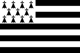
The flag of Brittany, a region in the northwest of France, is called the Gwenn-ha-du, which means white and black, in Breton. The flag was designed in 1923 by Morvan Marchal. It is also unofficially used in the department of Loire-Atlantique, although this now belongs to the Pays de la Loire and not to the region of Brittany, as the territory of Loire-Atlantique is historically part of the province of Brittany. Nantes, its prefecture, was once one of the two capital cities of Brittany.

<span class="mw-page-title-main">Lower Brittany</span> Western region of Brittany

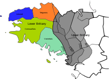
Lower Brittany denotes the parts of Brittany west of Ploërmel, where the Breton language has been traditionally spoken, and where the culture associated with this language is most prolific. The name is in distinction to Upper Brittany, the eastern part of Brittany, which is of a predominantly Romance culture.

<span class="mw-page-title-main">Bretons</span> Celtic ethnic group

The Bretons are a Celtic ethnic group native to Brittany, north-western France. They trace their heritage to groups of Brittonic speakers who emigrated from southwestern Great Britain, particularly Cornwall and Devon, mostly during the Anglo-Saxon settlement of Britain. They migrated in waves from the 3rd to 9th century into Armorica, which was subsequently named Brittany after them.

<span class="mw-page-title-main">Batz-sur-Mer</span> Commune in Pays de la Loire, France

Batz-sur-Mer is a commune in the Loire-Atlantique department in western France.

<span class="mw-page-title-main">Rennes 2 University</span>

Rennes 2 University is a public university located in Upper Brittany, France. It is one of the four universities of the Academy of Rennes. The main campus is situated in the northwest of Rennes in the Villejean neighborhood, not far from the other campus, at La Harpe.

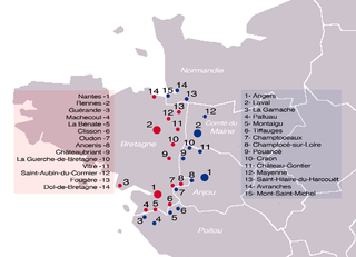
The Battle of Jengland took place on 22 August 851, between the Frankish army of Charles the Bald and the Breton army of Erispoe, Duke of Brittany. The Bretons were victorious, leading to the signing of the Treaty of Angers in September 851 which secured Breton independence.

<span class="mw-page-title-main">Upper Brittany</span> Eastern portion of Brittany

Upper Brittany is the eastern part of Brittany, France, which is predominantly of a Romance culture and is associated with the Gallo language. The name is in counterpoint to Lower Brittany, the western part of the ancient province and present-day region, where the Breton language has traditionally been spoken. However, there is no certainty as to exactly where the line between 'Upper' and 'Lower' Brittany falls.

<span class="mw-page-title-main">Pays de la Mée</span>

<span class="mw-page-title-main">French–Breton War</span>

The French–Breton War lasted from 1487 to 1491. The cause of this war was the approaching death of the Breton Duke Francis II of Brittany, who had no clear successor. If not resolved, this meant a resumption of issues from a previous War of the Breton Succession (1341–1364), which had rival claimants allying with England or France, resulting in an ambiguous peace treaty that failed to prevent future succession disputes.

<span class="mw-page-title-main">Vikings in Brittany</span> Viking occupation of Brittany (c. 800s–1000s)

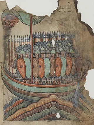
Vikings were active in Brittany during the Middle Ages, even occupying a portion of it for a time. Throughout the 9th century, the Bretons faced threats from various flanks: they resisted full incorporation into the Frankish Carolingian Empire yet they also had to repel an emerging threat of the new duchy of Normandy on their eastern border by these Scandinavian colonists.

References

  1. Fañch Broudic, À la recherche de la frontière. La limite linguistique entre Haute et Basse-Bretagne aux xixe et xxe siècles, Brest, Ar Skol Vrezoneg, 1997
  2. Kenneth Jackson, Linguistic Geography and the History of the Breton Language [ permanent dead link ] (1961), online at reference-global.com
  3. John T. Koch (ed.), Celtic Culture: a historical encyclopedia, Volumes 1-5 (2006), p. 244
  4. Hervé Abalain, Histoire de la langue bretonne (1995), p. 30
  5. Encyclopædia Britannica, Volume 4 (1894), p. 320
  6. Helen Kelly-Holmes, Minority language broadcasting: Breton and Irish (2001), p.32