Linou

Last updated
Linou

Λινού
E thea apo ton Prophete Elia - panoramio.jpg
Cyprus relief location map.jpg
Red pog.svg
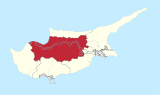
Linou
Location in Cyprus
Coordinates: 35°4′23″N32°53′33″E / 35.07306°N 32.89250°E / 35.07306; 32.89250 Coordinates: 35°4′23″N32°53′33″E / 35.07306°N 32.89250°E / 35.07306; 32.89250
Country Cyprus
District Nicosia District
Population
(2001) [1]
  Total207
Time zone UTC+2 (EET)
  Summer (DST) UTC+3 (EEST)
Website www.linou.org.cy

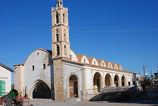
Linou (Greek : Λινού) is a remote village in the Nicosia District of Cyprus, located south of the Skouriotissa mines and 5 km north of Evrychou with a population of 207, 25% of them refugees.[ citation needed ]

Greek language language spoken in Greece, Cyprus and Southern Albania

Greek is an independent branch of the Indo-European family of languages, native to Greece, Cyprus and other parts of the Eastern Mediterranean and the Black Sea. It has the longest documented history of any living Indo-European language, spanning more than 3000 years of written records. Its writing system has been the Greek alphabet for the major part of its history; other systems, such as Linear B and the Cypriot syllabary, were used previously. The alphabet arose from the Phoenician script and was in turn the basis of the Latin, Cyrillic, Armenian, Coptic, Gothic, and many other writing systems.

Nicosia District district of Republic of Cyprus

Nicosia District is one of the six districts of Cyprus. Its main town is the island country's capital city, Nicosia. The TRNC-controlled northern part of the district is the Lefkoşa District of the unrecognized Turkish Republic of Northern Cyprus.

Cyprus Island country in Mediterranean

Cyprus, officially the Republic of Cyprus, is an island country in the Eastern Mediterranean and the third largest and third most populous island in the Mediterranean, located south of Turkey, west of Syria and Lebanon, northwest of Israel, north of Egypt, and southeast of Greece.

Linou's earliest evidence of habitation dates back to the Middle Ages. The name of the village, however, appears to have ancient Greek roots, suggesting life in the region since antiquity; on old maps it is marked as Linu. Linou – often shown on local maps as Linou-Flasou – is built on the right of the river valley Karkoti at an approximate altitude of 310 meters above sea level. The village receives an average annual rainfall of about 360 millimeters. In the village, some of the older residents own plots of farmland where they cultivate olives, citrus fruits, some vegetables (peas and tomatoes), wheat, legumes and a few types of fruit tree (apple, pear, plum and mespilies). There are also large areas of uncultivated land, occupied by wild natural vegetation, mostly pine, together with thyme, rosemary, and hawthorn.

Linou has population fluctuations. In 1881 the standing population was 214, which increased to 226 in 1891. This later decreased to 184 in 1901, but a decade later, increased to 189, to 201 in 1921 and 252 in 1931. In 1946, occupants of Linou numbered 311 (272 Greek Cypriots and 39 Turkish Cypriots), which later increased to 338 in 1960 (320 Greek Cypriots and 18 Turkish Cypriots). After 1964, as a result of intercommunal riots that followed the rebellion of the Turkish Cypriots, the few Turkish Cypriot inhabitants of Linou left the village and moved to the adjacent mixed Turkish Cypriot villages. In 1973, the population of the village was 300 (all Greek Cypriots), which then increased to 349 in 1976, but decreased to 332 in 1982. The last census, in 2001, showed 207, all Cypriot inhabitants.

Related Research Articles

Kyrenia Place in Kyrenia District, Cyprus

Kyrenia is a city on the northern coast of Cyprus, noted for its historic harbour and castle. It is under the de facto control of Northern Cyprus.

Rizokarpaso Place in Famagusta District, Cyprus

Rizokarpaso is a town on the Karpas Peninsula in the northeastern part of Cyprus. While nominally part of the Famagusta District of the Republic of Cyprus, it has been under the de facto control of Northern Cyprus since the partition of the island in 1974.

Pyla Place in Larnaca District, Cyprus

Pyla is a village in Larnaca District, Cyprus. It is one of only four villages located within the United Nations Buffer Zone, the other three being Athienou, Troulloi and Deneia. Pyla is located in the eastern part of the island, adjacent to the British Sovereign Base Area of Dhekelia. From a legal point of view, it is administered as all other areas controlled by the government of the Republic of Cyprus.

Kormakitis Place in Kyrenia District, Cyprus

Kormakitis is a small village in Cyprus. It is under the de facto control of Northern Cyprus. Kormakitis is one of four traditionally Maronite villages in Cyprus, the other three being Asomatos, Agia Marina and Karpaseia. The Maronites of Kormakitis traditionally speak their own variety of Arabic called Cypriot Maronite Arabic (CMA) in addition to Greek and recently Turkish. Cape Kormakitis is named after the village.

Peristerona Place in Nicosia District, Cyprus

Peristerona is a large village about 32 kilometres west of the capital Nicosia, on the foothills of the Troodos Mountain range in the Morphou basin. It is built on the west bank of the river that bears the same name, which is a tributary of the river Serrachis, at an average altitude of 250 meters.

Pergamos, Cyprus Place in Larnaca District, Cyprus

Pergamos is a Turkish Cypriot village in Larnaca District, Cyprus, 4 km north of Pyla, almost surrounded by the British Sovereign Base Area (SBA) at Dhekelia. Pergamos is under the de facto control of Northern Cyprus.

Prastio, Famagusta Place in Famagusta District, Cyprus

Prastio is a small village in Cyprus, 19 km west of Famagusta. De facto, it is under the control of Northern Cyprus. It is administered by the municipality of Sinta (İnönü).

Arediou in Nicosia District, Cyprus

Arediou is a village located in the Nicosia District of Cyprus. A developing village which has the advantage of "Arediou intercity Bus Station" connecting the province villages with the suburbs of Nicosia.

Kofinou village in Larnaca District, Cyprus

Kofinou is a village located in the Larnaca District of Cyprus. It is situated where the roads from Nicosia, Larnaca and Limassol trisected, prior to the by-pass built in the 1990s.

Skylloura village in Nicosia District, Cyprus

Skylloura is a village located in the Nicosia District of Cyprus, about halfway between the towns of Morphou and Nicosia. It is administered by the Lefkoşa District of Northern Cyprus. In the town the two main roads Morphou-Nicosia and Kyrenia-Lapithos-Skylloura meet.

Diorios village in Kyrenia District, Cyprus

Diorios or Dhiorios is a village in the Kyrenia District of Cyprus, 2 km west of Myrtou. It is under the de facto control of Northern Cyprus.

Deneia village in Nicosia District, Cyprus

Deneia is a village in the Nicosia District of Cyprus, west of Mammari. It is one of only four villages located within the United Nations Buffer Zone, the other three being Pyla, Athienou and Troulloi.

Agios Epifanios Soleas village in Nicosia District, Cyprus

Agios Epifanios is a village in the Nicosia District of Cyprus, located 3 km west of Linou. Prior to 1974, the village was inhabited primarily by Turkish Cypriots. Today the village is very insignificantly populated.

Omorfita Place in Nicosia District, Cyprus

Omorfita or Kuchuk Kaimakli is a northeastern quarter of Nicosia, Cyprus. Omorfita has been divided since 1974, its biggest chunk being under the de facto control of Northern Cyprus.

Asha, Cyprus Place in Famagusta District, Cyprus

Asha, also transliterated Assia, is a village in the Famagusta District of Cyprus, located 6 km northwest of Vatili. It is under the de facto control of Northern Cyprus.

Marathovounos village in Famagusta District, Cyprus

Marathovounos is a village in the Famagusta District of central Cyprus. It is under the de facto control of Northern Cyprus.

Tavros, Cyprus Place in Famagusta District, Cyprus

Tavros is a village in the Famagusta District of Cyprus, located on the Karpass Peninsula. It is in the southern part of the peninsula between Bogaz and Koma Yialou (Kumyali), 1½ miles from the peninsula’s south coast. It is under the de facto control of Northern Cyprus.

Koilani Place in Limassol District, Cyprus

Koilani is a village in the Limassol District of Cyprus, located 3 km south of Pera Pedi.

Malia, Cyprus Place in Limassol District, Cyprus

Malia is a village in the Limassol District of Cyprus, located 4 km south of Omodos.

Ayioi Omoloyites, Nicosia in Nicosia District, Cyprus

Ayioi Omoloyites is a Neighbourhood, Quarter, Mahalla or Parish of Nicosia, Cyprus and the parish church thereof. Its name in Greek is Άγιοι Ομολογητές, which means Holy Confessors and also has the name Ayii Omoloyitades used in older English language works and Turkish.

References

  1. Census 2001