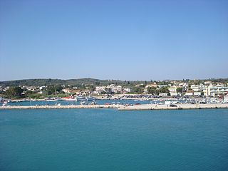
Kastro-Kyllini is a former municipality in Elis, West Greece, Greece. Since the 2011 local government reform it is part of the municipality Andravida-Kyllini, of which it is a municipal unit. The municipal unit has an area of 49.322 km2. The population was 3,622 in 2011. The municipality Kastro-Kyllini was created in 1999 as part of the Kapodistrias reform from the formerly independent communities Kyllini, Kato Panagia, Kastro and Neochori, that became municipal districts. After the 2011 Kallikratis reform, these municipal districts became (dependent) communities. Its seat of administration was the small port town of Kyllini.

Kalavryta is a town and a municipality in the mountainous east-central part of the regional unit of Achaea, Greece. The town is located on the right bank of the river Vouraikos, 24 kilometres south of Aigio, 40 km southeast of Patras and 62 km northwest of Tripoli. Notable mountains in the municipality are Mount Erymanthos in the west and Aroania or Chelmos in the southeast. Kalavryta is the southern terminus of the Diakopto-Kalavryta rack railway, built by Italian engineers between 1885 and 1895.

Aroania is a village and a former municipality in Achaea, West Greece, Greece. Since the 2011 local government reform it is part of the municipality Kalavryta, of which it is a municipal unit. The municipal unit has an area of 173.804 km2. The population is 1,619. The seat of administration was in the town Psofida. The municipality is named after the village and the mountain.

Iardanos is a former municipality in Elis, West Greece, Greece. Since the 2011 local government reform it is part of the municipality Pyrgos, of which it is a municipal unit. The municipal unit has an area of 62.723 km2. Its seat of administration was the village Vounargo. Iardanos is enclosed by the municipal units of Amaliada to the north, and Pyrgos to the south.

Falaisia is a village and a former municipality in southwestern Arcadia, Peloponnese, Greece. Since the 2011 local government reform it is part of the municipality Megalopoli, of which it is a municipal unit. The municipal unit has an area of 274.926 km2. The seat of the municipality was in Leontari, 5 km northwest of the village Falaisia. The municipal unit Falaisia is located in the northern foothills of the Taygetus mountains, south of Megalopoli and north of Kalamata. It borders on Laconia to the southeast, and Messenia to the southwest.

Larnaca District is one of the six districts of Cyprus. Its capital is Larnaca. It is bordered on the east by Famagusta District, on the north by Nicosia District and on the west by Limassol District.

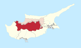
Nicosia District is one of the six districts of Cyprus. Its main town is the island country's capital city, Nicosia. The TRNC-controlled northern part of the district is the Lefkoşa District of the unrecognized Turkish Republic of Northern Cyprus.

Varnavas is a town in East Attica, Greece. Since the 2011 local government reform it is part of the municipality Marathon, of which it is a municipal unit. It is part of Athens metropolitan area.

Makryneia is a former municipality in Aetolia-Acarnania, West Greece, Greece. Since the 2011 local government reform it is part of the municipality Agrinio, of which it is a municipal unit. The municipal unit has an area of 149.687 km2. Population 3,681 (2011). The seat of the municipality was in Gavalou. The municipal unit is located south and southeast of Lake Trichonida, and northwest of the mountain Arakynthos. There are farmlands near the lake shore, and forests on the mountain slopes. Makryneia is southeast of Agrinio, northeast of Missolonghi and northwest of Naupactus.

North Kynouria or Vóreia Kynouría is a municipality in Arcadia, Greece. It is located in the eastern part of the regional unit, between the northwestern shores of the Argolic Gulf and northern Laconia. Its land area is 576.981 km². Its population is 10,341. The seat of the municipality is in Astros. Its largest other towns or villages are Ágios Andréas, Paralio Astros (1,043), Doliana (846), Ágios Pétros (717), Meligoú (684), Korakovoúni (659), Prastós (336) and Kastrí (335).

Evrychou is a village in Cyprus. It is located in the Nicosia District and the agricultural centre of the "Solea" region located about 50 km south-west of Nicosia and 30 km from Troodos Mountains.

Deryneia is a large village in the island of Cyprus. It is located on the east side of the island, 2 km (1 mi) south of the city of Famagusta. The population of the village is 5,758 and it consists of a municipality since 1994. The current mayor is Andros Karayiannis. Since the 1974 Turkish invasion of Cyprus, around 75% of the village terrain is in Northern Cyprus. The village is 12 kilometers from the famous resort of Ayia Napa. The "Ghost Town" of Varosha can be clearly viewed from the roof of the Cultural Centre, as can the craters from shells fired during the invasion in the field opposite.

Alona is a village in the Nicosia District of Cyprus. It located on the north side of the Troodos peaks between Madari and Papoutsa mountain ranges at an altitude of 1200 meters.
Pano Koutrafas is a small village in the Nicosia District of Cyprus, 3 km south of Kato Koutrafas. Before 1974, the village was inhabited almost exclusively by Turkish Cypriots. Today the village is largely uninhabited.
Agioi Vavatsinias is a village in the Larnaca District of Cyprus, 3 km north of Ora. Its population in 2011 was 131.

Moni is a village in the Limassol District of Cyprus, located 2 km east of Pyrgos.

Pano Akourdaleia is a village in the Paphos District of Cyprus, located 2 km west of Miliou. The village is the birthplace of Cypriot politician and Euro-MP Takis Hadjigeorgiou.
Agioi Iliofotoi or Eliophotes was a village in the Nicosia District of Cyprus, east of Kato Moni. Agioi Iliofotoi was inhabited exclusively by Turkish Cypriots. It was abandoned in 1964 when they all sought refuge in Nicosia. Agioi Iliofotoi was subsequently demolished, either in the late 1970s or 1980s. In 1960, it had a population of 91.

Limassol District or Lemesos is one of the six districts of Cyprus. As of 2011, it had a population of 239,842, 77% of which was urban. Its main city is Limassol. Part of the British Overseas Territory of Akrotiri and Dhekelia forms an enclave on the Akrotiri Peninsula, under the sovereignty of the United Kingdom.


