Cyprus, officially the Republic of Cyprus, is an island country in the Eastern Mediterranean and the third largest and third most populous island in the Mediterranean, located south of Turkey, west of Syria and Lebanon, northwest of Israel, north of Egypt, and southeast of Greece.

Northern Cyprus, officially the Turkish Republic of Northern Cyprus, is a de facto state that comprises the northeastern portion of the island of Cyprus. Recognised only by Turkey, Northern Cyprus is considered by the international community to be part of the Republic of Cyprus.

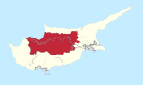
The United Nations Buffer Zone in Cyprus is a demilitarized zone, patrolled by the United Nations Peacekeeping Force in Cyprus (UNFICYP), that was established in 1964 and extended in 1974 after the cease fire of 16 August 1974, following the Turkish invasion of Cyprus, and the de facto partition of the island into the area controlled by the Republic of Cyprus and the Turkish Republic of Northern Cyprus in the North. The zone, also known as the Green Line, stretches for 180 kilometres from Paralimni in the east to Kato Pyrgos in the west, where a separate section surrounds Kokkina. The zone cuts through the centre of Nicosia, separating the city into southern and northern sections. In total, it spans an area of 346 square kilometres (134 sq mi), varying in width from less than 20 metres to more than 7 kilometres.
Turkish Cypriots or Cypriot Turks are mostly ethnic Turks originating from Cyprus. Following the Ottoman conquest of the island in 1571, about 30,000 Turkish settlers were given land once they arrived in Cyprus. Additionally, many of the islanders converted to Islam during the early years of Ottoman rule. Nonetheless, the influx of mainly Muslim settlers to Cyprus continued intermittently until the end of the Ottoman period. Today, while Northern Cyprus is home to a significant part of the Turkish Cypriot population, the majority of Turkish Cypriots live abroad, forming the Turkish Cypriot diaspora. This diaspora came into existence after the Ottoman Empire transferred the control of the island to the British Empire, as many Turkish Cypriots emigrated primarily to Turkey and the United Kingdom for political and economic reasons. The emigration was exacerbated by the intercommunal violence in the 1950s and 1960s, as Turkish Cypriots had to live in enclaves in Cyprus.

Kokkina is a coastal exclave (pene-exclave) of the de facto Northern Cyprus, and a former Turkish Cypriot village and enclave in Cyprus. It is surrounded by mountainous territory, with the Morphou Bay on its northern flank. Kokkina sits several kilometres west of the Northern Cyprus mainland and is a place with symbolic significance to Turkish Cypriots, because of the events of August 1964. In 1976, all Kokkina inhabitants were transferred to Gialousa and the exclave has since functioned as a North Cyprus Defence Force military camp.

Louroujina is a village in Cyprus, located within the salient that marks the southernmost extent of Northern Cyprus. It was one of the largest Turkish Cypriot villages in Cyprus before the Turkish invasion. In 1974, Louroujina was secured so as to be placed within a contiguous Turkish Cypriot zone, which later became Northern Cyprus. The United Nations Buffer Zone separates the Louroujina salient from the area controlled by the Republic of Cyprus. There is now a tunnel which has been designed to enter the village without going through any army points. The village is now open to everyone there are many historic untouched buildings in this village.
Tymbou or Tymbu is a village in the central Mesaoria plain of Cyprus. Tymbou is under the de facto control of Northern Cyprus. After 1960, the village was inhabited exclusively by Greek Cypriots; in 1973, they numbered 1,288. The original population fled the village in 1974, following the Turkish Invasion of Cyprus. As of 2011, Tymbou had a population of 384.
Geroskipou is a coastal town in Cyprus, east of Paphos. Its current population is approximately 7,000 and it is the second largest municipality in the Paphos District. Yeroskipou, with its remarkable five-domed Byzantine church of Agia Paraskevi, and its Folk Art Museum, is a popular tourist destination. It is known especially for the production of Turkish Delight or "lokum". The town is the only place in the world which has protected geographical indication (PGI) for the popular dessert.
Potamia is a village in the north-east of Cyprus in the district of Nicosia, close to the Green Line separating it from the area of the breakaway, unrecognised Northern Cyprus. Together with Pyla and Rizokarpaso, Potamia forms one of the few remaining ethnically mixed communities in Cyprus, made up of Greek and Turkish Cypriots.
There was a period of political and violent conflict in Cyprus, also known as the Cyprus crisis and EOKA period, between the Greek Cypriots and Turkish Cypriots, between 1955 and 1964.

Peristerona is a large village about 32 kilometres west of the capital Nicosia, on the foothills of the Troodos Mountain range in the Morphou basin. It is built on the west bank of the river that bears the same name, which is a tributary of the river Serrachis, at an average altitude of 250 meters.

Pano Polemidia is a large village lying partly in the Limassol District of Cyprus. It has a population of 3443 according to the 2011 census. It is near Kato Polemidia.

Akanthou is a village in Famagusta District, on the northern coast of Cyprus. Akanthou is under the de facto control of Northern Cyprus. As of 2011, it had a population of 1,459.
Skylloura is a village located in the Nicosia District of Cyprus, about halfway between the towns of Morphou and Nicosia. It is administered by the Lefkoşa District of Northern Cyprus. In the town the two main roads Morphou-Nicosia and Kyrenia-Lapithos-Skylloura meet.
Loutros is a small village located in the Nicosia District of Cyprus, west of the town of Karavostasi. De facto, it is under the control of Northern Cyprus.

Deneia is a village in the Nicosia District of Cyprus, west of Mammari. It is one of only four villages located within the United Nations Buffer Zone, the other three being Pyla, Athienou and Troulloi.
Neo Chorio is a village in the Nicosia District of Cyprus, 2 km south of Kythrea. De facto, it is under the control of Northern Cyprus.
Agia Marina is a village in Cyprus, situated 24 km west of Nicosia. It takes its name from Marina the Monk, the Christian saint of Byzantine Syria. De facto, Agia Marina is under the control of Northern Cyprus.

Neo Chorio is a village in the Paphos District of Cyprus, about 8 km west of Polis. Until 1958, it had a mixed Greek- and Turkish Cypriot population with a Greek Cypriot majority. Amid the intercommunal violence, the Turkish Cypriot inhabitants of Neo Chorio fled to Androlykou, a nearby Turkish Cypriot village. In 1975, following the Turkish invasion of the previous year and subsequent division of the island, most Turkish Cypriots of Neo Chorio resettled in Myrtou, now in Northern Cyprus. In 2011, Neo Chorio had a population of 519.
Turkish settlers in Northern Cyprus, also referred to as Turkish immigrants are a group of mainland Turkish people who have settled in Northern Cyprus since the Turkish invasion in 1974. It is estimated that these settlers and their descendants now make up about half the population of the North. The vast majority of the Turkish settlers were given houses and land that legally belong to Greek Cypriots by the internationally unrecognised, breakaway Northern Cypriot regime. The group is heterogeneous in nature and is composed of various sub-groups, with varying degrees of integration. Mainland Turks are generally considered to be more conservative than the highly secularized Turkish Cypriots, and tend to be more in favor of a two-state Cyprus. However, not all settlers support nationalist policies.


