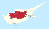
Katokopia

Last updated

{{Infobox settlement | name = Katokopia

| native_name =

| native_name_lang = | settlement_type = | image_skyline = | image_alt = | image_caption = | image_flag = | flag_alt = | image_seal = | seal_alt = | image_shield = | shield_alt = | nickname = | motto = | image_map = | map_alt = | map_caption = | pushpin_map = Cyprus |pushpin_relief =y | pushpin_label_position = | pushpin_map_alt = | pushpin_map_caption = | coordinates = 35°10′27″N33°03′04″E / 35.17417°N 33.05111°E / 35.17417; 33.05111 | coor_pinpoint = | coordinates_footnotes = | subdivision_type = Country ( de jure ) | subdivision_name = Flag of Cyprus.svg  Cyprus | subdivision_type1 =    District | subdivision_name1 = [[Nicosia District] | established_title = | established_date = | founder = | seat_type = | seat = | government_footnotes = | leader_party = | leader_title = | leader_name = | unit_pref = Metric | area_footnotes = | area_urban_footnotes = | area_rural_footnotes = | area_metro_footnotes = | area_magnitude = | area_note = | area_water_percent = | area_rank = | area_blank1_title = | area_blank2_title = | area_total_km2 = | area_land_km2 = | area_water_km2 = | area_urban_km2 = | area_rural_km2 = | area_metro_km2 = | area_blank1_km2 = | area_blank2_km2 = | area_total_ha = | area_land_ha = | area_water_ha = | area_urban_ha = | area_rural_ha = | area_metro_ha = | area_blank1_ha = | area_blank2_ha = | length_km = | width_km = | dimensions_footnotes = | elevation_footnotes = | elevation_m = | population_footnotes = [1] | population_total = 817 | population_as_of = 2011 | population_density_km2 = auto | population_demonym = | population_note = | timezone1 = EET | utc_offset1 = +2 | timezone1_DST = EEST | utc_offset1_DST = +3 | postal_code_type = | postal_code = | area_code_type = | area_code = | iso_code = | blank_name = Climate | blank_info = Csa | website = | footnotes = }}

Contents

Katokopia (Greek : Kατωκοπιά [locally [katokoˈpca] ]; Turkish : Zümrütköy) is a village located in the Nicosia District of Cyprus, 7 km east of Morphou. De facto , it is under the control of Northern Cyprus.

Originally inhabited by Greek Cypriots, since the Turkish invasion in 1974, the village has been solely inhabited by Turks. [2]

Culture, sports, and tourism

Turkish Cypriot Zümrütköy Sports Club was founded in 1975, and now in Cyprus Turkish Football Association (CTFA) K-PET 2nd League. [3]

Katokopia is the original home of Greek Cypriot football club Doxa Katokopia.

Related Research Articles

<span class="mw-page-title-main">Nicosia</span> Capital of Cyprus and Northern Cyprus (de facto)

Nicosia is the capital and largest city of Cyprus. It is the southeasternmost of all EU member states' capital cities.

{{Infobox settlement |official_name = Shelbyville |settlement_type = City |nickname = The Walking Horse Capital of the World and The Pencil City |motto =

<span class="mw-page-title-main">North Nicosia</span> Capital of Northern Cyprus

North Nicosia or Northern Nicosia is the capital and largest city of the de facto state of Northern Cyprus. It is the northern part of the divided city of Nicosia, and is governed by the Nicosia Turkish Municipality. As of 2011, North Nicosia had a population of 61,378 and a metropolitan area with a population of 82,539.

<span class="mw-page-title-main">Nicosia District</span> District of Cyprus

Nicosia District is one of the six districts of Cyprus. Its main town is the island country's capital city, Nicosia. The de-facto TRNC-controlled northern part of the district is the Lefkoşa District of the unrecognized Turkish Republic of Northern Cyprus.

{{infobox settlement| name = Sirsa district | settlement_type = District of Haryana | total_type = Total | native_name = | image_skyline = Haryana takhatmal.jpg | image_caption = Fields in Sirsa district | image_map = India - Haryana - Sirsa.svg | map_alt = | map_caption = Location in Haryana | coordinates = | coor_pinpoint = Sirsa, Haryana|Sirsa | subdivision_type = Country | subdivision_name = India | subdivision_type1 = State | subdivision_name1 = Haryana | subdivision_type2 = | subdivision_name2 = | established_title = Established | established_date = | seat_type = Headquarters | seat = Sirsa | parts_type = [[Tehsils of India|Tehsils]= 1. Sirsa, kalanwali 2. Dabwali, 3. Rania, 4. Ellenabad,goriwala, nauthsari copta | area_total_km2 = 4277 | area_footnotes = | population_as_of = 2011 | population_total = 1,295,189 | population_footnotes = | population_urban = | population_density_km2 = vechical regstration =rto HR24 commerialHR57 auto | demographics_type1 = Demographics | demographics1_title1 = Literacy | demographics1_info1 = 60.55% | demographics1_title2 = Sex ratio | demographics1_info2 = 897 | demographics_type2 = Languages | demographics2_title1 = Official | demographics2_info1 = Hindi, English | demographics2_title2 = Regional | demographics2_info2 = Haryanvi | leader_title = | leader_name = | timezone1 = IST | utc_offset1 = +05:30 | registration_plate = HR24 HR57 |blank_name_sec1 = Major highways | blank_info_sec1 = NH 9 | blank_name_sec2 = Lok Sabha constituencies | blank_info_sec2 = Sirsa | blank1_name_sec2 = Vidhan Sabha constituencies | blank1_info_sec2 = 5 | website = sirsa.nic.in }} Sirsa district is the largest district of Haryana state by Area. Sirsa is the district headquarters. It is located on National Highway 9 and 250 kilometres (160 mi) from the capital Delhi. On 1 September 1975, Sirsa became a district by taking Sirsa and Dabwali tahsils from Hisar District. There are a total of 342 villages in Sirsa district.

<span class="mw-page-title-main">Aryob</span>

{{Infobox settlement |official_name =Aryob |native_name =اریوب |other_name = |settlement_type = |image_skyline = |imagesize = 300px |image_caption = |image_flag = |flag_size = |image_seal = |seal_size = |image_shield = |shield_size = |image_blank_emblem = |blank_emblem_type = |blank_emblem_size = |nickname = |motto = |image_map = |mapsize = |map_caption = |image_map1 = |mapsize1 = |map_caption1 = |pushpin_map = Afghanistan |pushpin_label_position =bottom |pushpin_mapsize =300 |pushpin_map_caption =Location in Afghanistan |coordinates = 33.9662°N 69.8061°E |subdivision_type = Country |subdivision_name =  Afghanistan |subdivision_type1 = Province |subdivision_type2 = District |subdivision_type3 = |subdivision_type4 = |subdivision_name1 = Paktia |subdivision_name2 = [[Zazi District][Dara Adam Khel]

{{Infobox settlement

 language = Bodo
<span class="mw-page-title-main">Bilariaganj</span> Municipal Corporation City in Uttar Pradesh, India

{{Infobox settlement | name = Bilariyaganj | other_name = | nickname = | settlement_type = City Azamgarh | image_skyline =

{{Infobox settlement | name = Butterworth | other_name = Gcuwa | image_skyline = Butterworth main street (1569685818).jpg | image_caption = Butterworth, Main Street | pushpin_map = South Africa Eastern Cape#South Africa#Africa | coordinates = 32°20′S28°09′E | subdivision_type = Country | subdivision_name = South Africa | subdivision_type1 = Province | subdivision_name1 = Eastern Cape | subdivision_type2 = [[Districts of South Africa|Distric | subdivision_type3 = Municipality | subdivision_name3 = Mnquma | subdivision_type4 = Main Place | established_title = Established | leader_title = Councillor | area_footnotes = | area_total_km2 = 26.34 | population_footnotes = | population_total = 44041 | population_as_of = 2011 | population_density_km2 = auto | demographics_type1 = Racial makeup (2011) | demographics1_footnotes = | demographics1_title1 = Black African | demographics1_info1 = 98.2% | demographics1_title2 = Coloured | demographics1_info2 = 0.7% | demographics1_title3 = Indian/Asian | demographics1_info3 = 0.4% | demographics1_title4 = White | demographics1_info4 = 0.5% | demographics1_title5 = Other | demographics1_info5 = 0.2% | demographics_type2 = First languages (2011) | demographics2_footnotes = | demographics2_title1 = Xhosa | demographics2_info1 = 92.7% | demographics2_title2 = English | demographics2_info2 = 3.0% | demographics2_title3 = | demographics2_info3 = | demographics2_title4 = | demographics2_info4 = | demographics2_title5 = Other | demographics2_info5 = 4.3% | timezone1 = SAST | utc_offset1 = +2 | postal_code_type = Postal code (street) | postal_code = 4960 | postal2_code_type = PO box | postal2_code = 4960 | area_code_type = Area code | area_code = 047 }} Butterworth, also known as Gcuwa, is a town in the Eastern Cape Province, South Africa. Butterworth has a population of 45,900 and is situated on the N2 national highway 111 km north of East London.

{{Infobox settlement |official_name = Smithdale, Mississippi |settlement_type = Unincorporated community |nickname = |motto =

<span class="mw-page-title-main">Outline of Northern Cyprus</span> Overview of and topical guide to Northern Cyprus

The following outline is provided as an overview of and topical guide to Northern Cyprus:

{{Infobox settlement |name = Baluwa Madanpur |other_name = Baluwa Madanpur |native_name = बलुवा मदनपुर |nickname = बलुवा मदनपुर |settlement_type = Village development committee |motto = |image_skyline = |image_caption = |image_flag = |image_seal = |image_map = |mapsize = 300px |map_caption = Map of the village development committees in Rautahat District |pushpin_map = Nepal |pushpin_label_position = bottom |pushpin_mapsize = 300 |pushpin_map_caption = Location in Nepal |subdivision_type = Country |subdivision_name =  Nepal |subdivision_type1 = Zone |subdivision_name1 = Narayani Zone |subdivision_type2 = District |subdivision_name2 = Rautahat District | |government_footnotes = |government_type = |leader_title = |leader_name = |leader_title1 = |leader_name1 = |established_title = |established_date = |unit_pref = |area_footnotes = |area_total_km2 = |population_as_of = 1991 |population_footnotes = |population_note = |population_total = 1903 |population_density_km2 = auto |population_blank1_title = Ethnicities |timezone = Nepal Time |utc_offset = +5:45 |timezone_DST = |utc_offset_DST = |coordinates = 26.95°N 85.39°E |elevation_footnotes = |elevation_m = |postal_code_type = |postal_code = |area_code = |blank_name = |blank_info = |website = |footnotes = |ward. = 5 | total popolation. Approximately = 2243 Higest caste = Yadav

Haspolat or Mia Milia is an industrialised village and an eastern suburb of North Nicosia in Cyprus. As a result of the Turkish invasion of Cyrpus, is under the de facto control of Northern Cyprus. The Cyprus International University and the new Nicosia water treatment plant are located within its boundaries.

Assia is a village in the Famagusta District of Cyprus, located 6 km northwest of Vatili. It is under the de facto control of Northern Cyprus.

<span class="mw-page-title-main">Malia, Cyprus</span> Place in Limassol District, Cyprus

Malia is a village in the Limassol District of Cyprus, located 4 km south of Omodos.

{{Infobox settlement |official_name = Kolfe Keranio |native_name = ኮልፌ ቀራኒዮ ክፍለ ከተማ |native_name_lang = am |settlement_type = [[Districts of Addis Ababa|Sub-city] |image_skyline = |image_caption = |imagesize = |nickname = |image_flag = |image_seal = |image_map = Kolfe Keranio .png |map_caption = Kolfe Keranio (red) within Addis Ababa |established_title = |established_date = |pushpin_map = Ethiopia |mapsize = |pushpin_map_caption = Location in Ethiopia |subdivision_type = Country |subdivision_name =  Ethiopia |subdivision_type1 = City |subdivision_name1 = Addis Ababa |leader_title = |leader_name = |area_magnitude = |area_total_km2 = 61.25 |area_land_km2 = |area_water_km2 = |area_note = |population_as_of = 2011 |population_urban = |population_note = |population_total = 546,219 |population_metro = |area_metro_km2 = |population_density_km2 = 7,448.5 |timezone = East Africa Time |utc_offset = +3 |timezone_DST = |utc_offset_DST = |coordinates = 9°0′49.75″N38°42′21.49″E |elevation_m = |elevation_ft = |latitude = |longitude = |area_code = (+251) 11 |website = |footnotes = }} Kolfe Keranio, also spelled Kolfe Keraneo or simply Kolfe, is a district (sub-city) of Addis Ababa, Ethiopia. As of 2011 its population was of 546,219.

<span class="mw-page-title-main">Köşklüçiftlik</span> Place in Nicosia District, Cyprus

Köşklüçiftlik is a quarter of North Nicosia in Northern Cyprus. In 2011, it had a population of 2,939.

<span class="mw-page-title-main">Göçmenköy</span> Place in Nicosia District, Cyprus

Göçmenköy is a quarter of North Nicosia in Northern Cyprus. As of 2011, it had a population of 3,003. It was founded in 1966 as a settlement for the Turkish Cypriots displaced by the intercommunal violence. The formerly rural area became heavily urbanized in the 1960s and 70s. Göçmenköy became a vibrant part of North Nicosia, and is home to the Atatürk Sports Complex, which is home to the Nicosia Atatürk Stadium, the largest stadium in Northern Cyprus. It co-hosts an annual international festival.

{{Infobox settlement | name = Pleasant Valley | native_name = | native_name_lang = | settlement_type = Neighborhood | image_skyline = | image_alt = | image_caption = | image_flag = | flag_alt = | image_seal = | seal_alt = | image_shield = | shield_alt = | nickname = | motto = | image_map = ------ pleasent_valley--------

{{Infobox settlement |official_name = Arroyo Hondo, New Mexico |settlement_type = Census-designated place |image_skyline = |imagesize = |image_caption = |pushpin_map = New Mexico#USA |pushpin_label = Arroyo Hondo |pushpin_label_position = |pushpin_map_caption = |coordinates = 35°36′59″N105°56′25″W |subdivision_type = Country |subdivision_name = United States |subdivision_type1 = State |subdivision_name1 = New Mexico |subdivision_type2 = County |subdivision_name2 = [[Taos County, New Mexico|Taos Co |subdivision_type3 = |subdivision_name3 = |established_title = |established_date = | unit_pref = Imperial | area_footnotes = | area_total_sq_mi = 3.17 | area_land_sq_mi = 3.17 | area_water_sq_mi = 0.00 | area_total_km2 = 8.22 | area_land_km2 = 8.22 | area_water_km2 = 0.00 | area_water_percent = | population_total = 331 | population_as_of = 2020 | population_footnotes = | population_density_sq_mi = 104.32 | population_density_km2 = 40.28 |timezone = Mountain (MST) |utc_offset = -7 |timezone_DST = MDT |utc_offset_DST = -6 |elevation_footnotes = |elevation_ft = 6962 |postal_code_type = ZIP Code |postal_code = 87508 |area_code = 505 |blank_name = FIPS code |blank_info = 35-05002 |blank1_name = GNIS feature ID |blank1_info = 2812758 |website = |footnotes = }} Arroyo Hondo is an unincorporated community and census-designated place (CDP) in Santa Fe County, New Mexico, United States. It was first listed as a CDP prior to the 2020 census.

References

  1. "KKTC 2011 Nüfus ve Konut Sayımı" [TRNC 2011 Population and Housing Census](PDF). TRNC State Planning Organization. 6 August 2013. p. 22. Archived from the original (PDF) on 6 November 2013.
  2. https://docs.google.com/viewer?a=v&q=cache:HFPwLt8LC_AJ:www.unhchr.ch/Huridocda/Huridoca.nsf/0/f4f30ed4b0ee47f5c1256af4003755db/%24FILE/G0115564.pdf+Fterycha&hl=en&gl=uk&pid=bl&srcid=ADGEESjJWaRiEGn3eIn6YUUnIhuA6FmNv2q_uUpAFejCqfJngD6TmPkNyTFZ7lACAEWg4f823_M1QrgWdPN6j2kJZo7iVpwusSqFxL2I-1ee2GXe8hCBkxduvWQHg1kpf_FmdB2_WCFC&sig=AHIEtbQ8XjiXdelgW7MpJxFm8XIM5DM69Q [ bare URL ]
  3. Northern Cyprus Archived 2015-06-18 at the Wayback Machine Association of Football Clubs