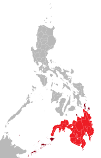
Mindanao is the second-largest island in the Philippines, after Luzon and seventh-most populous island in the world. Located in the southern region of the archipelago, the island is part of an island group of the same name that also includes its adjacent islands, notably the Sulu Archipelago. As of 2015 census, Mindanao has 25,700,000 inhabitants, while the entire island group has an estimated population of 27,021,036 as of 2021.

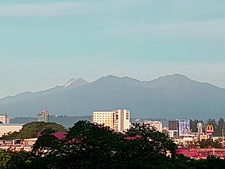
Mount Apo, also known locally as Apo Sandawa, is a large solfataric, dormant stratovolcano on the island of Mindanao, Philippines. With an elevation of 2,954 meters (9,692 ft) above sea level, it is the highest-mountain in the Philippine Archipelago and 24th-highest peak of an island on Earth. Located between Davao City and Davao del Sur in the Davao Region, and Cotabato in Soccsksargen, Mount Apo is the most-prominent mountain in the Philippines. The peak overlooks from Davao City 45 kilometers (28 mi) to the northeast, Digos 25 kilometers (16 mi) to the southeast, and Kidapawan 20 kilometers (12 mi) to the west. It is a protected area and a Natural Park of the Philippines.

Davao del Norte is a province in the Philippines located in the Davao Region in Mindanao. Its capital and largest city is Tagum. The province also includes Samal Island to the south in the Davao Gulf.

Davao Region, formerly called Southern Mindanao, is an administrative region in the Philippines, designated as Region XI. It is situated at the southeastern portion of Mindanao and comprises five provinces: Davao de Oro, Davao del Norte, Davao del Sur, Davao Oriental, and Davao Occidental.

Davao Oriental is a province in the Philippines located in the Davao Region in Mindanao. Its capital is city of Mati, and it borders the province of Davao de Oro to the west, and Agusan del Sur and Surigao del Sur to the north. The province is the traditional homeland of the Mandaya and Kalagan/Kaagan.

Davao de Oro, officially the Province of Davao de Oro, is a province in the Philippines located in the Davao Region in Mindanao. Its capital is Nabunturan. It used to be part of the province of Davao del Norte until it was made a separate province in 1998.

Sarangani, officially the Province of Sarangani, is a province in the Philippines located in the Soccsksargen region. Its capital is Alabel. With a 230-kilometre (140 mi) coastline along the Sarangani Bay and Celebes Sea, the province is at the southernmost tip of Mindanao island, and borders South Cotabato and Davao del Sur to the north, Davao Occidental to the east, and the Celebes Sea to the south.

Davao City, officially the City of Davao, is a 1st class highly urbanized city in the Davao Region, Philippines. The city has a total land area of 2,443.61 km2 (943.48 sq mi), making it the largest city in the Philippines in terms of land area. It is the third-most populous city in the Philippines after Quezon City and Manila, and the most populous in Mindanao. As of 2020, the city has a total population of 1,776,949 people.
The legislative districts of Davao City are the representations of the highly urbanized city of Davao in the various national legislatures of the Philippines. The city is currently represented in the lower house of the Congress of the Philippines through its first, second, and third congressional districts.
The legislative districts of Davao del Norte are the representation of the province of Davao del Norte in the various national legislatures of the Philippines. The province is currently represented in the lower house of the Congress of the Philippines through its first and second congressional districts.
The legislative districts of Davao del Sur are the representations of the province of Davao del Sur in the various national legislatures of the Philippines. The province is currently represented in the lower house of the Congress of the Philippines through its lone congressional district.
The legislative districts of Davao Oriental are the representations of the province of Davao Oriental in the various national legislatures of the Philippines. The province is currently represented in the lower house of the Congress of the Philippines through its first and second congressional districts.

The Christian And Missionary Alliance Churches of the Philippines (CAMACOP) is a Christian evangelical group in the Philippines that originated from The Christian and Missionary Alliance (C&MA). It is one of the largest evangelical groups in the Philippines.

The following outline is provided as an overview of and topical guide to the Philippines:

These lists contain an overview of the government recognized cultural properties in the Philippines. The lists are based on the official lists provided by the National Commission for Culture and the Arts, National Historical Commission of the Philippines, and the National Museum of the Philippines.
The Kalagan are a subroup of the Mandaya-Mansaka people who speak the Kalagan language. The Kalagan comprise three subgroups which are usually treated as different tribes: the Tagakaulo, the Kagan, and the Kal’lao people of Samal. They are native to areas within Davao del Sur, Compostela Valley, Davao del Norte, Davao Oriental, and North Cotabato; between the territories of the Blaan people and the coastline. They were historically composed of small warring groups. They are renowned as agriculturalists, cultivating rice, corn, abaca, and coconut for cash crops, whereas their counterparts living along the coast practice fishing.

Historical markers are installed by the National Historical Commission of the Philippines (NHCP) in the Philippines and places abroad that signify important events, persons, structures, and institutions in Philippine national and local histories. The plaques themselves are permanent signs installed by the NHCP in publicly visible locations on buildings, monuments, or in special locations. Local municipalities and cities can also install markers of figures and events of local significance. Though they may have the permission of the NHCP, these markers are barred from using the seal of the Republic of the Philippines.

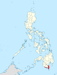
Davao Occidental is the 81st and newest province in the Philippines located in the Davao Region in Mindanao. Its capital is the municipality of Malita. To the east lies the Davao Gulf. It also shares a maritime border with the Indonesian province of North Sulawesi to the south.


