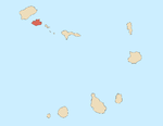
Mindelo is a port city in the northern part of the island of São Vicente in Cape Verde. Mindelo is also the seat of the parish of Nossa Senhora da Luz, and the municipality of São Vicente. The city is home to 93% of the entire island's population. Mindelo is known for its colourful and animated carnival celebrations, with roots in Portuguese traditions.

Estádio Municipal Adérito Sena is a multi-use stadium in Mindelo, Cape Verde. It is currently used mostly for football matches and is the home stadium of FC Derby as well as CS Mindelense, Académica, GD Amarantes and Batuque FC and the lesser club of Corinthians São Vicente. The stadium holds 5,000 people and area is 105x68 m and its ground is artificial grass. The stadium is owned by the municipality of São Vicente and is operated by the São Vicente Regional Football Association (ARFSV). It is a certified stadium by FIFA for international competition as well as friendly matches

Primary school education in Cape Verde is mandatory between the ages of 6 and 14 years and free for children ages 6 to 12. In 1997, the gross primary enrollment rate was 148.8 percent. Primary school attendance rates were unavailable for Cape Verde as of 2001. While enrollment rates indicate a level of commitment to education, they do not always reflect children’s participation in school. Textbooks have been made available to 90 percent of school children, and 90 percent of the teachers have attended in-service teacher training. Its literacy rate as of 2010 ranges from 75 to 80% and being the highest in the whole of West Africa south of the Sahara.

Ribeira Brava is a city on the island of São Nicolau, Cape Verde. It is the seat of the Ribeira Brava Municipality. Its population was 1,936 at the 2010 census. The town is situated in the valley of the river Ribeira Brava, east of the main mountain range of the island. The name of the river is Portuguese for "rough stream", referring to the violent behaviour of the river during rains. The city has a colonial look with Portuguese style buildings, charming parks and gardens, small winding streets, and steep hills.
Raúl Pires Ferreira Chaves was a Portuguese civil engineer and inventor. A graduate of the Instituto Superior Técnico of Lisbon, he lived and primarily worked in Portugal, Portuguese Cape Verde and Portuguese Guinea.

Farol de Dona Maria Pia is a lighthouse at the southernmost point of the island of Santiago, Cape Verde. It stands on the headland Ponta Temerosa, at the entrance of Praia Harbour, 2 km south of the city centre of Praia. The lighthouse was built in 1881 and was named after Maria Pia of Savoy, queen of Portugal at the time. The octagonal tower is 21 m high and its focal plane is 25 m above mean sea level. It is painted white. The lighthouse is used for navigational purposes.

Farol de Ponta Norte is a lighthouse in the northernmost point of the island of Sal, Cape Verde. It is located near the headland Ponta Norte. The original lighthouse was a 13 metres high cast iron tower, constructed in 1897. This was replaced with a masonry tower around 1940, which is now in ruins. The current light is on a 5 metres metal tower.
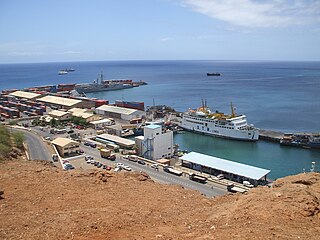
Praia Harbor is the port of the city of Praia in the southern part of the island of Santiago, Cape Verde. It is situated in a natural bay of the Atlantic Ocean. Since the latest modernization in 2014, it has 2 long quays, 3 shorter quays, a quay for fishing boats with fish processing installations, 2 container parks, 2 roll-on/roll-off ramps and a passenger terminal. The total length of the quays is 863 m, and the maximum depth is 13.5 m. The port of Praia played an important role in the colonization of Africa and South America by the Portuguese. With 817,845 metric tonnes of cargo and 85,518 passengers handled (2017), it is the second busiest port of Cape Verde, after Porto Grande (Mindelo).
The Architecture of Cape Verde has different architectural styles in the nation. Unlike the African mainland, Cape Verde was uninhabited until 1461 when the Portuguese arrived, most of the other islands were first inhabited after the end of the 15th century. Its architecture was introduced in the 1460s and has its first origins from Portuguese settlers from the Madeira Islands, after the first arrival of mainland Africans, a bit of African architecture would be elements mainly in rural areas. The Manueline was its first architectural style on the island, it was later followed by Renaissance, Baroque, Pombaline, Early Modern and Modern. It was one of the last in the whole of Africa to introduce architecture late. Cape Verde has one of the richest architecture in the western portion of West Africa, the sub-Saharan portion, the richest probably being Mali.
Farol da Preguiça is a lighthouse located near the shore of Baía de São Jorge in Preguiça on the island of São Nicolau in northern Cape Verde. It is a masonry hut, coloured white. It sits at about 18 meters above sea level in the village, it is seven meters tall and its focal height is at 25 meters above sea level. Its focal range is 5 nautical miles. Its characteristic is Fl (2+1) R 15s.
The following lists events that happened during 1960 in Cape Verde.

Liceu Domingos Ramos is a public secondary school in the northern part of the city centre (Plateau) of Praia, Cape Verde. As of 2015, it has 2,300 students, 63 classes and 110 teachers. It was established as Liceu Adriano Moreira in 1960. In 1975, at the independence of Cape Verde, it was renamed Liceu Domingos Ramos.
Patrice Lumumba Preparatory School is a lyceum located in the southwestern part of the city centre of São Tomé, São Tomé and Príncipe. It is the oldest secondary school in the country, established in 1952. It currently has about 3,000 students.