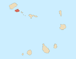
Santo Antão is the westernmost island of Cape Verde. At 779 km2 (301 sq mi), it is the largest of the Barlavento Islands group, and the second largest island of Cape Verde. The nearest island is São Vicente to the southeast, separated by the sea channel Canal de São Vicente. Its population was 40,547 in 2015, making it the third most populous island of Cape Verde after Santiago and São Vicente. Its largest city is Porto Novo on the south coast.

São Nicolau is one of the Barlavento (Windward) islands of Cape Verde. It is located between the islands of Santa Luzia and Sal. Its population is 12,424 (2015), with an area of 343 km². The main towns are Ribeira Brava and Tarrafal de São Nicolau.

Santiago is the largest island of Cape Verde, its most important agricultural centre and home to half the nation’s population. Part of the Sotavento Islands, it lies between the islands of Maio and Fogo. It was the first of the islands to be settled: the town of Ribeira Grande was founded in 1462. Santiago is home to the nation's capital city of Praia.

Monte Cara is a mountain in western part of the island of São Vicente, Cape Verde. Its elevation is 490 m. It resembles a human face looking at the sky, hence its name, which means "face mountain". It is a landmark of the city of Mindelo, from which it can be seen across Porto Grande Bay.
Monte Verde is a mountain in the eastern part of the island of São Vicente, Cape Verde. At 744 m elevation, it is the island's highest point. The mountain is located 6 km (4 mi) east of the city centre of Mindelo.

Estádio Municipal Adérito Sena is a multi-use stadium in Mindelo, Cape Verde. It is currently used mostly for football matches and is the home stadium of FC Derby as well as CS Mindelense, Académica, GD Amarantes and Batuque FC and the lesser club of Corinthians São Vicente. The stadium holds 5,000 people and area is 105x68 m and its ground is artificial grass. The stadium is owned by the municipality of São Vicente and is operated by the São Vicente Regional Football Association (ARFSV). It is a certified stadium by FIFA for international competition as well as friendly matches

Cesária Évora Airport is Cape Verde's fourth-busiest airport, located on the island of São Vicente, nearly 5 kilometres (3.1 mi) from the centre of Mindelo. It is located in the valley area in the west of the island and is north of the village of São Pedro. Its runway is 1,975 metres (6,480 ft) long and its width is 45 metres (148 ft).
Madeiral or Monte Madeiral is a mountain in the southeastern part of the island of São Vicente, Cape Verde. Its elevation is 680 meters. The village Madeiral, part of the settlement Ribeira de Calhau, lies at its northern foot.

Caixa is a mountain in the southern part of the island of São Vicente.It is situated 7 km south of the city centre of Mindelo. Its elevation is 535 metres (1,755 ft).
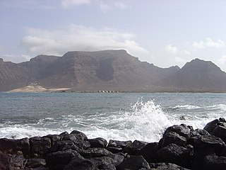
Baleia is a mountain valley in the eastern part of the island of São Vicente. Its orientation is west-east, and it lies south of Baía das Gatas and northwest of the beach Praia Grande. At its western end is Monte Verde, the highest point of São Vicente. At its eastern end is the Atlantic Ocean. Access is either from the coast or from Mato Inglês over a mountain pass.

Monte São João is a low mountain in the central part of the island of São Vicente, Cape Verde. Its elevation is 154 m. It is situated 3 km southwest of the city centre of Mindelo.
Pico do Vento is a mountain in the eastern part of the island of São Vicente. It is situated south of the Ribeira do Calhau valley, 12 km southeast of the island capital Mindelo.
The São Vicente Super Cup is a regional SuperCup competition played during the season in São Vicente Island, Cape Verde. The super cup competition is organized by the São Vicente Regional Football Association. Its current champions is FC Derby who won their second title The regional champion competes with the cup champion. The 2015 edition was held, as Mindelense won both the regional and cup titles, the regional winner competed with a runner up in the regional cup.

Cape Verde or Cabo Verde, officially the Republic of Cabo Verde, is an island country spanning an archipelago of 10 volcanic islands in the central Atlantic Ocean. It forms part of the Macaronesia ecoregion, along with the Azores, Canary Islands, Madeira, and the Savage Isles. In ancient times these islands were referred to as "the Islands of the Blessed" or the "Fortunate Isles". Located 570 kilometres (350 mi) west of the Cape Verde Peninsula off the coast of Northwest Africa, the islands cover a combined area of slightly over 4,000 square kilometres (1,500 sq mi).

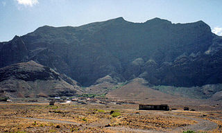
Ribeira de Calhau is a settlement in the eastern part of the island of Sao Vicente, Cape Verde. It takes its name from the river Ribeira do Calhau, and comprises the villages of Madeiral, Ribeira de Calhau and Calhau. Madeiral and Ribeira de Calhau are located in the river valley, Calhau is on the east coast. In 2010 its population was 1,177. The valley is surrounded by the mountains Viana, Madeiral, Pico do Vento and Monte Verde.
1910s – 1920s – 1930s – 1940s – 1950s – 1960s – 1970s – 1980s – 1990s – 2000s
Monte António Gomes is a mountain in the northeastern part of the island of São Vicente, Cape Verde. Its elevation is 362 meters. It is 1.6 km north of Monte Verde, 2.3 km southeast of the village Salamansa and 6 km east of the city centre of Mindelo.