Baía de Salamansa

Last updated
Baía de Salamansa
Salamansa 2006.jpg
Baía de Salamansa near the village of Salamansa. Santo Antão Island in background.
Cape Verde location map.svg
Red pog.svg
Baía de Salamansa
Location North of Salamansa,, São Vicente, Cape Verde
Coordinates 16°54′50″N24°56′56″W / 16.914°N 24.949°W / 16.914; -24.949
Max. length 3.68 km (2.29 mi)
Max. width 2.6 km (1.6 mi)
Average depth 5 m (16 ft)

Baía de Salamansa (Portuguese for "Salamansa Bay") is a bay on the north coast of the island of Santiago in Cape Verde north of the village of Salamansa and inside the Atlantic Ocean. Nearby bays are Porto Grande Bay being more than 3.5 km west and Baía das Gatas and Praia Grande being more than 2.6 km almost east. Monte João d'Évora and others likes to the west and smaller mountains to the south. East is predominant hilly and has elevations up to 60 m. Ponta da Salamansa is located northwest which separates the bay and Canal de São Vicente but northeast being simply the Atlantic. Another point is located to the northeast which forms a small headland to the east. A 1 km long beach is to the south which its width extends from 50 meters, 200 meters at Salamansa as far as about 500 meters and is known as Praia da Salamansa. Another beach and sandy area is Areia Negra to the southwest extending about 1 km inland. Areia Negra surrounds a part of Ribeira João d'Évora and are surrounded by hills.

Bay A recessed, coastal body of water connected to an ocean or lake

A bay is a recessed, coastal body of water that directly connects to a larger main body of water, such as an ocean, a lake, or another bay. A large bay is usually called a gulf, sea, sound, or bight. A cove is a type of smaller bay with a circular inlet and narrow entrance. A fjord is a particularly steep bay shaped by glacial activity.

São Vicente, Cape Verde island in Cape Verde

São Vicente is one of the Barlavento Islands, the northern group within the Cape Verde archipelago in the Atlantic Ocean, off the west African coast. It is located between the islands of Santo Antão and Santa Luzia, with the Canal de São Vicente separating it from Santo Antão.

Cape Verde Country comprising ten islands off the Northwest coast of Africa

Cape Verde or Cabo Verde, officially the Republic of Cabo Verde, is an island country spanning an archipelago of 10 volcanic islands in the central Atlantic Ocean. It forms part of the Macaronesia ecoregion, along with the Azores, Canary Islands, Madeira, and the Savage Isles. In ancient times these islands were referred to as "the Islands of the Blessed" or the "Fortunate Isles". Located 570 kilometres (350 mi) west of the Cape Verde Peninsula off the coast of Northwest Africa, the islands cover a combined area of slightly over 4,000 square kilometres (1,500 sq mi).

Contents

Most of the bay is shallow with its depth about 10 meters below. Its length is 3.68 km from east to west and its width is 1.85 km. 1 km north has the depth of 35 m, 2 km north is about 75 m deep. Further areas are not shallow as the area northwest at midway with Santo Antão has the depth down to about 400 m and at 1000 m deep more than 8 km north.

The bay give its name to a nearby village in the south.

History

The point and its bay were mentioned in Imray's 1888 map as "Salamasa Bay" and "Ponta de Salamasa" as he visited Cape Verde and other countries. Until the early 20th century, the spelling was "Bahía de Salamansa".

In 2015, touristic developments began southeast of the bay, housing and also hotels, resorts, villas and probably a golf course are planned, the planning is uncertain, it covers most of the northeasternmost part and a small eastern part belongs to Baía das Gatas. Also in the same year, a species of gobies was discovered and were distinct from other gobies in the area and were described as the Salamansa goby (Gobius salamansa). [1]

Goby common name of fish

Goby is a common name for many species of small to medium sized ray-finned fish, normally with large heads and tapered bodies, which are found in marine, brackish and freshwater environments. Traditionally most of the species called gobies have been classified in the order Perciformes as the suborder Gobioidei but in the 5th Edition of Fishes of the World this suborder is elevated to an order Gobiiformes within the clade Percomorpha. Not all the species in the Gobiiformes are referred to as gobies and the "true gobies" are placed in the family Gobiidae, while other species referred to as gobies have been placed in the Oxudercidae.. Goby is also used to describe some species which are not classified within the order Gobiiformes, such as the engineer goby or convict blenny Pholidichthys leucotaenia. The word goby derives from the Latin gobius meaning "gudgeon", and some species of goby, especially the sleeper gobies in the family Eleotridae and some of the dartfishes are called "gudgeons", especially in Australia.

The Salamansa goby is a species of marine fish from the family Gobiidae, the true gobies. It is only known from the Bay of Salamansa in the north of the island of São Vicente, Cape Verde, where it occurs to a depth of about 1 metre (3.3 ft). The species was named and described by Samuel P. Iglésias and Lou Frotté in 2015. The species name salamansa refers to the type location.

Related Research Articles

Mindelo Settlement in São Vicente, Cape Verde

Mindelo is a port city in the northern part of the island of São Vicente in Cape Verde. Mindelo is also the seat of the parish of Nossa Senhora da Luz, and the municipality of São Vicente. The city is home to 93% of the entire island's population. Mindelo is known for its colourful and animated carnival celebrations, with roots in Portuguese traditions.

Manuel d' Novas was a Cape Verdean poet and composer.

Monte Cara mountain in Cape Verde

Monte Cara is a mountain in western part of the island of São Vicente, Cape Verde. Its elevation is 490 m. It resembles a human face looking at the sky, hence its name, which means "face mountain". It is a landmark of the city of Mindelo, from which it can be seen across Porto Grande Bay.

São Pedro, Cape Verde Settlement in São Vicente, Cape Verde

São Pedro is a village in the southwestern part of the island of Sao Vicente, Cape Verde. It is situated on the south coast, approximately 10 km southwest of the island capital Mindelo. In 2010 its population was 991. Cesária Évora Airport, the island's international airport is directly north of São Pedro. It was mentioned as a small port as "P. St. Pedro" in the 1747 map by Jacques-Nicolas Bellin. The lighthouse Farol de D. Amélia sits on the Ponta Machado, 3 km west of the village.

Cesária Évora Airport airport

Cesária Évora Airport is Cape Verde's fourth-busiest airport, located on the island of São Vicente, nearly 5 kilometres (3.1 mi) from the centre of Mindelo. It is located in the valley area in the west of the island and is north of the village of São Pedro. Its runway is 1,975 metres (6,480 ft) long and its width is 45 metres (148 ft).

Ilhéu dos Pássaros island

Ilhéu dos Pássaros is an uninhabited rocky islet in the bay of Mindelo, São Vicente Island, Cape Verde. It lies about 1.3 km (0.8 mi) west of the headland Ponta João Ribeiro, and 3.5 km (2.2 mi) northwest of Mindelo city centre. It lies between the Porto Grande Bay and the Canal de São Vicente, the channel of the Atlantic Ocean that separates the islands of São Vicente and Santo Antão. There is a lighthouse on the islet.

Rádio Barlavento local radio station in Cape Verde broadcast in the Portuguese language

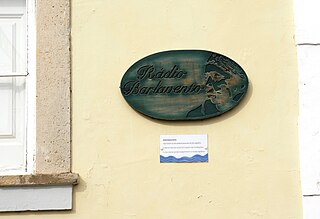
Rádio Barlavento was a radio station in Cape Verde which broadcast in the Portuguese language from 1955 until 1974. It was a shortwave (CR4AC) station broadcasting on 3930 kHz. From 1947 until 1955 it was called Rádio Clube do Mindelo. In 1974 it was seized by members of the Partido Africano da Independência de Guiné-Bissau e Cabo Verde - PAIGC, who sought to "get the station out of hands of those who aligned with colonial power." After this the station became Radio Voz de Sao Vicente. The station served the entire Barlavento island group including Santo Antão, São Vicente, São Nicolau, Sal and Boa Vista. The station was located in a building near downtown Mindelo, which is now the Centro Nacional de Artesanato e Design, and broadcast Cape Verdean traditional music, local programs, and Portuguese and some international programming. Rádio Voz de São Vicente later became an affiliate of RCV, Mindelo's own station would have another separate one and would be named Ràdio Nova.

Ponta João dÉvora

Ponta João d'Évora is a headland on the north coast of the island of São Vicente. It is located about 5 km northeast of Mindelo city centre and 3 km northwest of Salamansa.

Cesária Évora Cape Verdean singer

Cesária Évora, GCIH was a Cape Verdean vocalist and recording artist. Nicknamed the "Barefoot Diva" for performing without shoes, she was also known as the "Queen of Morna".

Avenida Marginal (Mindelo)

Avenida Marginal is an important street in Mindelo, São Vicente island, Cape Verde. It runs along the coast of the Porto Grande Bay, connecting the city centre with the northwestern outskirts (Matiota). Its southern end is the intersection with Rua Libertadores de África and Rua da Praia, that continues south along the coast. Avenida Marginal runs along the port of Mindelo, below Fortim d'El-Rei and along Praia da Laginha in Matiota.

Fantcha Cape Verdean singer

Fantcha is a Cape Verdean singer.

Tito Paris Cape Verdean musician

Tito Paris, is a singer and musician. He has a long career behind him. Tito Paris moved as a young man, aged 19, to Portugal. Lisbon continues to be his hometown even if he still goes back to his islands.

Orlanda Amarílis Lopes Rodrigues Fernandes Ferreira, known as Orlanda Amarílis was a Cape Verdean writer. She is considered to be a noteworthy writer of fiction whose main literary themes include perspectives on women’s writing, with depictions of various aspects of the lives of Cape Verdean women as well as depictions of the Cape Verdean diaspora. She has been described as "indisputably one of Cape Verde’s most talented writers".

Cais-do-Sodré té Salamansa is the first short story book published in 1974 by Cape Verdean writer Orlanda Amarílis. This collection consists of seven short stories in which the day-to-day lives of Cape Verdean emigrants are portrayed. Unlike some earlier romanticized accounts of the diaspora written by other Cape Verdean writers, Amarilis’ book projects a realistic and not-so-romanticized view of the Cape Verdean diaspora, and it is mainly concerned with the diaspora in Portugal.

Hermínia da Cruz Fortes, better known as Hermínia d'Antónia de Sal, was a Cape Verdean singer.

Djô dEloy

Djô d'Eloy born Adolfo de Jon Xalino was a Cape Verdean singer, composer and guitarist. He belonged to the Xalino family of singers. His greatest singles included "Arriola" and "Grandeza", both appeared in the album Nos Festa in 1981. he was of the Xalino family. His most famous singles were "Reanima" and "Celina". Alongside Bana, he was the founder of the nation's first music festival, the Baía das Gatas Music Festival.

Liceu Velho

Liceu Velho is a building in the eastern part of the city centre of Mindelo, Cape Verde. It is situated on Praça Dr. Duarte Silva, between Avenida Fernando Ferreira Fortes and Rua Franz Fanon, east of the Palácio do Povo. Since 2008, it houses the art school M_EIA, officially Instituto Universitário de Arte, Tecnologia e Cultura. It is also one of the locations of the School of Business and Governance (ENG) of the University of Cape Verde.

The Culture of the Island of São Vicente, Cape Verde is the second richest in the nation, with a range of customs and practices common in the islands,

References

  1. Iglésias, S.P., Frotté, L. & Sellos, D.Y. (2015): Gobius salamansa, a new species of goby (Gobiidae) from the Cape Verde Islands supported by a unique cephalic lateral line system and DNA barcoding. Ichthyological Research, 63 (3): 356-369.