Ribeira, Portuguese and Galician for stream or riverside, may refer to the following places:

Tarrafal de São Nicolau is a city in the western part of the island of São Nicolau, Cape Verde. With a population of 3,733, it is the most populous settlement of the island. It is the seat of the Tarrafal de São Nicolau Municipality, and the main port of the island. It is situated on the west coast, 9 km southwest of Ribeira Brava.

Estádio Municipal Adérito Sena is a multi-use stadium in Mindelo, Cape Verde. It is currently used mostly for football matches and is the home stadium of FC Derby as well as CS Mindelense, Académica, GD Amarantes and Batuque FC and the lesser club of Corinthians São Vicente. The stadium holds 5,000 people and area is 105x68 m and its ground is artificial grass. The stadium is owned by the municipality of São Vicente and is operated by the São Vicente Regional Football Association (ARFSV). It is a certified stadium by FIFA for international competition as well as friendly matches
Madeiral or Monte Madeiral is a mountain in the southeastern part of the island of São Vicente, Cape Verde. Its elevation is 680 meters. The village Madeiral, part of the settlement Ribeira de Calhau, lies at its northern foot.
The São Vicente Island or Regional Premier Division is a regional championship played in São Vicente Island, Cape Verde. The championship is organized by the São Vicente Regional Football Association. The winner of the championship plays in Cape Verdean football Championships of each season. In 1989, 2012, 2015, 2016 and 2017, a second place club participated in the national championships, Académica do Mindelo in 1989, Mindelense in 2014 and FC Derby in 2015 and in 2016 and will be for 2017. The 7th place club plays with a Second Division runner-up in a division decisional match to decide on promoting or remain in the Second Division. The last placed club relegated into the São Vicente Second Division. Up to around 2010, only a club was relegated into that division.

Praia Grande is a large beach on the northeast coast of the island of São Vicente, Cape Verde. It is 1.5 km northwest of the village Calhau. The white sandy beach is surrounded by volcanic rocks. It is accessible by road from Calhau and Baía das Gatas.

Viana is a low volcano in the southeastern part of the island of São Vicente, Cape Verde. Its elevation is 163 metres (535 ft). It is situated 3 kilometres (2 mi) south of Calhau and 14 kilometres (9 mi) southeast of the island capital Mindelo.
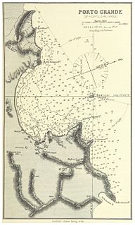
Ponta João Ribeiro is a cape in the northern part of the island of São Vicente, Cape Verde. It is 2.5 km northwest of the city centre of Mindelo. The cape divides the Canal de São Vicente and the Porto Grande Bay. The islet of Ilhéu dos Pássaros is approximately 1.3 km to the west. Near the cape is an abandoned military camp.

Pico do Vento is a mountain in the eastern part of the island of São Vicente. It is situated south of the Ribeira do Calhau valley, 12 km southeast of the island capital Mindelo.
Boca de Lapa is a beach in the southeast of the island of São Vicente, Cape Verde. The waves are strong at this beach, which makes it popular with surfers, who call it "Sandy Beach". It is only accessible by dirt road. It is 4.5 km south of Calhau.
Ribeira de Julião is a seasonal stream in the central part of the island of São Vicente in Cape Verde. Its source is in the hills southeast of the island capital Mindelo, and it empties into the Porto Grande Bay, a bay of the Atlantic Ocean, southwest of Mindelo. The village Ribeira Julião and the Mindelo neighbourhood Ribeira de Julião take their name from this stream.

Ribeira da Vinha is a village in the central part of the island of Sao Vicente, Cape Verde. It is situated in the plain southwest of the island capital Mindelo, approximately 3 km from the city centre.

Porto Novo is a city in the island of Santo Antão, in Cape Verde. It is the seat of the Porto Novo municipality. At the 2010 census, the town had 9,310 inhabitants, which makes it the most populous settlement of the island.

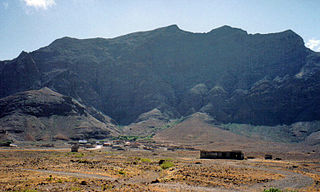
Ribeira de Calhau is a settlement in the eastern part of the island of Sao Vicente, Cape Verde. It takes its name from the river Ribeira do Calhau, and comprises the villages of Madeiral, Ribeira de Calhau and Calhau. Madeiral and Ribeira de Calhau are located in the river valley, Calhau is on the east coast. In 2010 its population was 1,177. The valley is surrounded by the mountains Viana, Madeiral, Pico do Vento and Monte Verde.
Ribeira Julião is a village in the central part of the island of Sao Vicente, Cape Verde. In 2010 its population was 611. It is situated in the valley of the stream Ribeira de Julião, south of the island capital Mindelo, 3.5 km from the city centre. An adjacent neighbourhood of Mindelo is named Ribeira de Julião.
The island of São Vicente in Cape Verde in the westcentral portion of the Barlavento Islands is home to several teams and clubs. The major professional clubs are CS Mindelense, FC Derby, Académica do Mindelo, Batuque FC and Amarante. The island also has a league named the São Vicente Island League, it is the oldest in Cape Verde, first it only had football, later it had basketball, volleyball, athletics and now futsal.