Mindelo is a port city in the northern part of the island of São Vicente in Cape Verde. Mindelo is also the seat of the parish of Nossa Senhora da Luz, and the municipality of São Vicente. The city is home to 93% of the entire island's population. Mindelo is known for its colourful and animated carnival celebrations, with roots in Portuguese traditions.

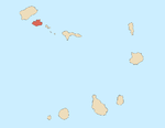
Santo Antão is the westernmost island of Cape Verde. At 779 km2 (301 sq mi), it is the largest of the Barlavento Islands group, and the second largest island of Cape Verde. The nearest island is São Vicente to the southeast, separated by the sea channel Canal de São Vicente. Its population was 40,547 in 2015, making it the third most populous island of Cape Verde after Santiago and São Vicente. Its largest city is Porto Novo on the south coast.

Porto Grande Bay, also Mindelo Bay, is a bay on the north coast of the island of São Vicente, Cape Verde. The main city of São Vicente, Mindelo, is situated at the bay. The Porto Grande Bay is a natural harbour. It stretches between the headlands Ponta João Ribeiro in the northeast and Ponta do Morro Branco in the west. To the northwest it opens towards the Canal de São Vicente, the channel between the islands São Vicente and Santo Antão. The small rocky islet Ilhéu dos Pássaros lies north of the bay.
Monte Verde is a mountain in the eastern part of the island of São Vicente, Cape Verde. At 744 m elevation, it is the island's highest point. The mountain is located 6 km (4 mi) east of the city centre of Mindelo.

Monte Gordo is a mountain on the island of São Nicolau, Cape Verde. At 1,312 m elevation, it is the island's highest point. It is situated in the western part of the island, 6 km west of the island capital Ribeira Brava. The mountain is of volcanic origin, less than 1 million years old. The boundary of the municipalities Tarrafal de São Nicolau and Ribeira Brava runs over the mountain. It is part of the Monte Gordo Natural Park.

Estádio Municipal Adérito Sena is a multi-use stadium in Mindelo, Cape Verde. It is currently used mostly for football matches and is the home stadium of FC Derby as well as CS Mindelense, Académica, GD Amarantes and Batuque FC and the lesser club of Corinthians São Vicente. The stadium holds 5,000 people and area is 105x68 m and its ground is artificial grass. The stadium is owned by the municipality of São Vicente and is operated by the São Vicente Regional Football Association (ARFSV). It is a certified stadium by FIFA for international competition as well as friendly matches

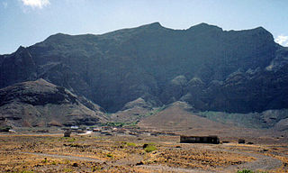
Nossa Senhora do Monte is a town located in the heart of the island of Brava, Cape Verde. It is the seat of the parish of Nossa Senhora do Monte. Its elevation is 650 m, and its population was 271 in 2010. Nossa Senhora do Monte is surrounded by mountains. Monte Fontainhas, Brava's tallest mountain reaching a height of 976 meters, is close to the village.
Madeiral or Monte Madeiral is a mountain in the southeastern part of the island of São Vicente, Cape Verde. Its elevation is 680 meters. The village Madeiral, part of the settlement Ribeira de Calhau, lies at its northern foot.

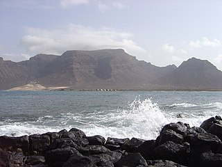
The Canal de São Vicente is a strait of the Atlantic Ocean separating the islands of Santo Antão and São Vicente, Cape Verde. At its narrowest point, it is 11 km (7 mi) wide. The ferry route between the ports of Porto Novo on Santo Antão and Mindelo on São Vicente crosses the canal. The channel begins in São Vicente's northwesternmost cape near Monte Cara up to the headland Ponta de João d'Évora in the northeast.
Baleia is a mountain valley in the eastern part of the island of São Vicente. Its orientation is west-east, and it lies south of Baía das Gatas and northwest of the beach Praia Grande. At its western end is Monte Verde, the highest point of São Vicente. At its eastern end is the Atlantic Ocean. Access is either from the coast or from Mato Inglês over a mountain pass.

Monte São João is a low mountain in the central part of the island of São Vicente, Cape Verde. Its elevation is 154 m. It is situated 3 km southwest of the city centre of Mindelo.
Monte Montona is a low mountain in the western part of the island of São Vicente, Cape Verde. Its elevation is 242 m. It is situated 4 km northeast of São Pedro and 6 km southwest of the island capital Mindelo.
Morro Branco is a low mountain in the northwest of the island of São Vicente. Its elevation is 86 m. It stands at the western end of the Porto Grande Bay, 4 km west of the city centre of Mindelo. In the 1920s military installations were built on the mountain.
Adriano Gonçalves, known by his stage name Bana and called the "King of Morna", was a Cape Verdean singer and performer of the morna style, the plaintive, melodic lament which is a staple musical style of the country.
The following lists events that happened during 2003 in Cape Verde.
Monte António Gomes is a mountain in the northeastern part of the island of São Vicente, Cape Verde. Its elevation is 362 meters. It is 1.6 km north of Monte Verde, 2.3 km southeast of the village Salamansa and 6 km east of the city centre of Mindelo.
Monte Tchota is a mountain located in the central part of Santiago Island in Cape Verde. Its elevation is 1,041 m. It is part of the Serra do Pico de Antónia Natural Park, and lies 1.5 km southeast of Pico de Antónia, the highest point of the island. The village Rui Vaz lies 3 km to the east.