
Kozhikode, also known in English as Calicut, is a city along the Malabar Coast in the state of Kerala in India. It has a corporation limit population of 609,224 and a metropolitan population of more than 2 million, making it the second most populous metropolitan area in Kerala and the 19th largest in India. Kozhikode is classified as a Tier 2 city by the Government of India.

Malappuram, is one of the 14 districts in the Indian state of Kerala, with a coastline of 70 km (43 mi). The most populous district of Kerala, Malappuram is home to around 13% of the total population of the state. The district was formed on 16 June 1969, spanning an area of about 3,554 km2 (1,372 sq mi). It is the third-largest district of Kerala by area. It is bounded by Western Ghats and the Arabian Sea on either side. The district is divided into seven Taluks: Eranad, Kondotty, Nilambur, Perinthalmanna, Ponnani, Tirur, and Tirurangadi.

Palakkad is one of the 14 districts in the Indian state of Kerala. It was carved out of the southeastern region of the former Malabar District on 1 January 1957. It is located at the central region of Kerala and is the second largest district in the state after Idukki. The city of Palakkad is the district headquarters. Palakkad is bordered on the northwest by the Malappuram district, on the southwest by the Thrissur district, on the northeast by Nilgiris district, and on the east by Coimbatore district of Tamil Nadu. The district is nicknamed "The granary of Kerala". Palakkad is the gateway to Kerala due to the presence of the Palakkad Gap, in the Western Ghats. The 2,383 m high Anginda peak, which is situated in the border of Palakkad district, Nilgiris district, and Malappuram district, in Silent Valley National Park, is the highest point of elevation in Palakkad district. Palakkad city is about 347 kilometres (216 mi) northeast of the state capital, Thiruvananthapuram.

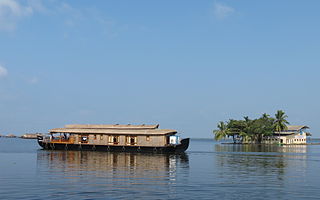
Kollam, also known by its former name Quilon, is an ancient seaport and city on the Malabar Coast of India bordering the Laccadive Sea, which is a part of the Arabian Sea. It is 71 km (44 mi) north of the state capital Thiruvananthapuram. The city is on the banks of Ashtamudi Lake and the Kallada river. Kollam is the fourth largest city in Kerala and is known for cashew processing and coir manufacturing. It is the southern gateway to the Backwaters of Kerala and is a prominent tourist destination. Kollam is one of the most historic cities with continuous settlements in India. Geographically, Quilon formation seen around coastal cliffs of Ashtamudi Lake, represent sediments laid down in the Kerala basin that existed during Mio-Pliocene times.
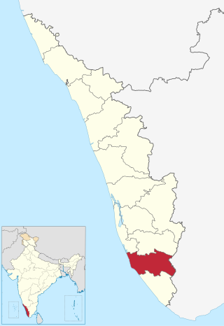
Kollam district, is one of 14 districts of the state of Kerala, India. The district has a cross-section of Kerala's natural attributes; it is endowed with a long coastline, a major Laccadive Sea seaport and an inland lake. The district has many water bodies. Kallada River is one among them, and land on the east bank of the river is East Kallada and that on the west bank is West Kallada.

Malabar District, also known as Malayalam District, was an administrative district on the southwestern Malabar Coast of Bombay Presidency (1792–1800), Madras Presidency (1800–1937), Madras Province (1937–1950) and finally, Madras State (1950–1956) in India. It was the most populous and the third-largest district in the erstwhile Madras State. The historic town of Calicut was the admisnitrative headquarters of this district.

Kozhikode, or Calicut district, is one of the 14 districts in the Indian state of Kerala, along its southwestern Malabar Coast. The city of Kozhikode, also known as Calicut, is the district headquarters. The district is 67.15% urbanised.

Malappuram is a city and the headquarters of the Malappuram district in Kerala, India. It is the 4th largest urban agglomeration in Kerala and the 20th largest in India and a city in the Indian state of Kerala, spread over an area of 158.20 km2 (61.08 sq mi) including the surrounding suburban areas. The first municipality in the district formed in 1970, Malappuram serves as the administrative headquarters of Malappuram district. Divided into 40 electoral wards, the city has a population density of 4,800 per square kilometre. According to the 2011 census, the Malappuram metropolitan area is the fourth largest urban agglomeration in Kerala after Kochi, Calicut, and Thrissur urban areas and the 20th largest in India with a total population of 3 million. It is the fastest growing city in the world with a 44.1% urban growth between 2015 and 2020 as per the survey conducted by Economist Intelligence Unit (EIU) based on the urban area growth during January 2020. Malappuram is situated 54 km southeast of Calicut and 90 km northwest of Palakkad. It is the first Indian municipal body to provide free Wi-Fi connectivity to its entire residents. Malappuram is also the first Indian municipal body to achieve the International Organization for Standardization certificate. It is also the first complaint-free municipality in the state.
Kerala is a state in south-western India. Most of Kerala's 34.8 million people are ethnically Malayalis. Most of the Malayalam and English speaking Keralites derive their ancestry from Dravidian communities that settled in Kerala. Additional ancestries derive from millennia of trade links across the Arabian Sea, whereby people of Arab, Jewish, Syrian, Portuguese, English and other ethnicities settled in Kerala. Many of these immigrants intermarried with native Malayalam speakers resulting in formation of many Muslim and Christian groups in Kerala. Some Muslims and Christians thus take lineage from Middle Eastern and European settlers who mixed with native population.
Koyilandy is a major town municipality and a taluk in Kozhikode district, Kerala on the Malabar Coast. The historical town is located right in the middle of the coast of Kozhikode district, between Kozhikode (Calicut) and Kannur, on National Highway 66.
Kerala, called Keralam in Malayalam, is a state on the Malabar Coast of India. It was formed on 1 November 1956, following the passage of the States Reorganisation Act, by combining Malayalam-speaking regions of the erstwhile regions of Cochin, Malabar, South Canara, and Travancore. Spread over 38,863 km2 (15,005 sq mi), Kerala is the 21st largest Indian state by area. It is bordered by Karnataka to the north and northeast, Tamil Nadu to the east and south, and the Lakshadweep Sea to the west. With 33 million inhabitants as per the 2011 census, Kerala is the 13th-largest Indian state by population. It is divided into 14 districts with the capital being Thiruvananthapuram. Malayalam is the most widely spoken language and is also the official language of the state.

Ramanattukara is a municipality census town in Kozhikode district in the Indian state of Kerala. This town was formerly called Kadungan Chira village. Ramanattukara is located 15 km away from Kozhikode city.
Many sports are played by the people in Kerala including both traditional sports and sports from other countries. Association football is the most popular sport in Kerala, followed by cricket. Kerala Blasters are the most supported football club in the whole state and participates in the Indian super league the top tier of Indian football. Whereas Gokulam Kerala FC a club which plays in the I-league derives most of its support from the Malabar region. However, larger numbers of Keralites also follow sports such as volleyball, hockey, badminton, and kabaddi. There are many large stadiums in Kerala across different cities. Trivandrum city has various sports venues such as Trivandrum International Stadium, Jimmy George Indoor Stadium, University Stadium (Thiruvananthapuram), Chandrasekharan Nair Stadium and Central Stadium whereas Kochi city has stadiums such as Jawaharlal Nehru International Stadium (Kochi) and Rajiv Gandhi Indoor Stadium. An international astro turf hockey stadium is located at Kollam city. Other major stadiums are EMS Stadium in Kozhikode, Malappuram District Sports Complex Stadium in Manjeri, Kannur Indoor Stadium in Kannur, Lal Bahadur Shastri Stadium in Kollam and many more. All these stadiums attest to the mass appeal of such sports among Keralites.

Kadalundi is a village in Kozhikode district, Kerala, India. It is a coastal village close to the Arabian Sea. Kadalundi is famous for its bird sanctuary, which is home to various migratory birds during certain seasons and has been recently declared as a bio-reserve. The Kadalundi–Vallikkunnu Community Reserve is the first community reserve in Kerala. The Kadalundi River and the Chaliyar river, two of the longest rivers of Kerala, merges with the Arabian Sea at Kadalundi. The first railway line in Kerala was laid in 1861 from Tirur to Chaliyam through Tanur, Parappanangadi, Vallikkunnu, and Kadalundi.

The Thiruvananthapuram–Kasaragod Hill Highway or State Highway 59 (SH-59) is a proposed state highway in Kerala. Upon completion, it will be the longest highway in Kerala, extending from Nandarapadavu in Kasaragod district to Parassala in Thiruvananthapuram district, at a length of 1332.16 km. The highway will pass through 13 of the 14 districts, the exception being Alappuzha as that district is not part of the hilly ranges of Kerala.
The Malappuram Metropolitan Area or Malappuram Urban Agglomeration is an urban agglomeration centred around the city of Malappuram, Manjeri in Malappuram district, Kerala, India. It is the 25th largest urban agglomeration in India and the 4th largest in Kerala.

Kollam Metropolitan Area is the 4th largest Metropolis in Kerala and 14th largest urban agglomeration in South India. It is one of the 10 fastest growing cities in the world covering an area of 364.51 km2 (2015) with a 31.1% urban growth between 2015 and 2020 as per the survey conducted by Economist Intelligence Unit (EIU) based on urban area growth during January 2020.

South Malabar refers to a geographical area of the southwestern coast of India covering some parts of the present-day Kerala state. South Malabar covers the regions included in present-day Kozhikode taluk of Kozhikode district, the whole area of Malappuram district, Chavakkad taluk of Thrissur district, and Palakkad district, excluding parts of Chittur taluk. The Fort Kochi region of Kochi city also historically belongs to South Malabar. The term South Malabar refers to the region of the erstwhile Malabar District south to the river Korapuzha, and bears a high cultural similarity to both the Cochin and the North Malabar regions.
