County routes in Putnam County, New York, known within the county as "county roads", are owned and maintained by the Putnam County Department of Highways and Facilities.
Most of the county road numbers, which are all two-digits, are signed with the standard yellow-on-blue pentagon route marker specified by the Manual on Uniform Traffic Control Devices (sign M1–6), which is also used in other counties throughout the state. However, the frequency of signage for county routes is not as high as that of state route signage. For instance, it is not uncommon for a road to have its number signed only on it and not on intersecting roads. This is reflected in local vernacular, as most residents refer to the county roads by name and not by number.
The first digit of a county road number indicates a town along the road, usually the town of origin. Exceptions to this scheme exist, however. The three villages in Putnam County are included with their respective towns.
On a town level, the numbers are assigned in a roughly west-to-east and south-to-north fashion. There is no known numbering scheme within the towns, as numbers are assigned based on the order of establishment. The presence of skipped numbers in the order (such as CR 31) implies that there are a few decommissioned roads, but some (like CR 52) were likely skipped intentionally to avoid confusion with state routes in the county.
Route | Length (mi) [1] | Length (km) | From | Via | To | Notes |
---|---|---|---|---|---|---|
CR 10 | 2.75 | 4.43 | NY 301 in Nelsonville | Fishkill Road | US 9 in Philipstown | |
CR 11 | 1.79 | 2.88 | NY 9D | Snake Hill Road in Philipstown | US 9 | |
CR 12 | 0.49 | 0.79 | NY 9D / NY 403 | Lower Station Road in Philipstown | Garrison Station | |
CR 13 | 0.78 | 1.26 | Westchester County line | Gallows Hill Road in Philipstown | CR 15 | |
CR 14 | 0.38 | 0.61 | Garrison Station | Upper Station Road in Philipstown | NY 9D | |
CR 15 | 1.46 | 2.35 | CR 13 in Philipstown | Sprout Brook Road | Indian Lake Road in Putnam Valley | |
CR 16 | 0.50 | 0.80 | NY 9D in Philipstown | Peekskill Road | NY 301 in Nelsonville | |
CR 17 | 0.15 | 0.24 | Cold Spring village line | Fair Street in Philipstown | NY 9D | |
CR 20 | 6.27 | 10.09 | Westchester County line | Oscawana Lake Road in Putnam Valley | North Shore Road | |
CR 21 | 11.34 | 18.25 | CR 20 in Putnam Valley | Peekskill Hollow Road | NY 301 in Kent | |
CR 22 | 2.14 | 3.44 | CR 20 | Church Road in Putnam Valley | CR 21 / CR 23 | |
CR 23 | 1.32 | 2.12 | Westchester County line | Mill Street in Putnam Valley | CR 21 / CR 22 | |
CR 24 | 2.30 | 3.70 | Westchester County line in Carmel | Wood Street | CR 30 in Putnam Valley | |
CR 30 | 1.86 | 2.99 | Taconic State Parkway in Putnam Valley | Secor Road | NY 6N in Carmel | |
CR 32 | 5.56 | 8.95 | NY 6N | Hill Street and Long Pond and Crane roads in Carmel | US 6 | |
CR 33 | 2.97 | 4.78 | NY 6N | West Lake and North Lake boulevards in Carmel | CR 72 | |
CR 34 | 4.02 | 6.47 | US 6 | Croton Falls Road in Carmel | Westchester County line (becomes CR 136) | |
CR 35 | 4.37 | 7.03 | US 6 | Stoneleigh Road in Carmel | Westchester County line (becomes CR 137) | |
CR 36 | 5.02 | 8.08 | US 6 in Carmel | Drewville Road | US 6 in Southeast | |
CR 37 | 2.16 | 3.48 | US 6 / NY 118 | Baldwin Place Road in Carmel | NY 6N | |
CR 38 | 2.00 | 3.22 | CR 34 | West Shore Drive in Carmel | CR 36 | |
CR 41 | 2.92 | 4.70 | NY 301 in Carmel | Gipsy Trail Road | Maynard Road in Kent | |
CR 42 | 6.01 | 9.67 | NY 301 | Farmers Mills Road in Kent | NY 52 | |
CR 43 | 3.46 | 5.57 | NY 311 in Patterson | Ludingtonville Road | I-84/NY 52 in Kent | |
CR 44 | 1.02 | 1.64 | CR 60 in Carmel | Palmer and Hill and Dale roads | CR 45 in Kent | |
CR 45 | 1.59 | 2.56 | NY 52 in Kent | Towners Road | CR 60 in Patterson | |
CR 46 | 0.87 | 1.40 | CR 60 in Patterson | Terry Hill Road | NY 311 in Kent | |
CR 47 | 3.50 | 5.63 | Kittredge Drive | Carmel-Kent Cliffs Road | NY 52 | Given to state in 1980; now part of NY 301. |
CR 47 | 0.20 | 0.32 | CR 21 | Old Route 301 in Kent | NY 301 | Former routing of NY 301 |
CR 48 | 0.67 | 1.08 | NY 52 | Horsepound Road in Kent | Nichols Street | |
CR 49 | 0.35 | 0.56 | CR 45 in Kent | Noonan Drive | CR 60 in Patterson | |
CR 50 | 0.47 | 0.76 | US 6 / US 202 / NY 22 | Sodom Road in Southeast | Dead end | Former routing of NY 22 |
Route | Length (mi) [1] | Length (km) | From | Via | To | Notes |
---|---|---|---|---|---|---|
CR 51 | 1.93 | 3.11 | CR 55 in Southeast | Turk Hill Road | US 202 / NY 22 in Brewster | |
CR 53 | 1.05 | 1.69 | Brewster village line | North Main Street and Tonetta Lake and Peaceable Hill roads in Southeast | US 6 | |
CR 54 | 3.50 | 5.63 | NY 22 | Milltown Road in Southeast | Connecticut state line | |
CR 55 | 2.38 | 3.83 | US 202 / NY 22 | Deans Corner and North Salem roads in Southeast | Westchester County line (becomes CR 310) | Formerly part of NY 124 |
CR 56 | 0.39 | 0.63 | US 202 / NY 22 / CR 51 in Southeast | Railroad Avenue | US 6 in Brewster | |
CR 57 | 1.32 | 2.12 | US 6 in Southeast | John Simpson Road | CR 60 in Carmel | |
CR 58 | 2.85 | 4.59 | CR 53 | Tonetta Lake and North Brewster roads in Southeast | NY 312 | |
CR 59 | 0.48 | 0.77 | CR 53 | Crosby Avenue in Southeast | CR 53 | |
CR 60 | 4.69 | 7.55 | NY 52 in Carmel | Fair Street | NY 311 in Patterson | |
CR 61 | 0.87 | 1.40 | Dead end at Croton River in Southeast | Old Doansburg Lane and Gage Road | CR 65 in Patterson | |
CR 62 | 3.10 | 4.99 | NY 312 in Southeast | Farm to Market Road | NY 164 in Patterson | |
CR 63 | 0.74 | 1.19 | NY 292 | Harmony Road in Patterson | Dutchess County line (becomes CR 69) | |
CR 64 | 2.36 | 3.80 | NY 164 | Cornwall Hill Road in Patterson | NY 311 | |
CR 65 | 4.45 | 7.16 | NY 22 in Southeast | Doansburg and East Branch roads | CR 68 in Patterson | |
CR 66 | 1.12 | 1.80 | CR 65 | Fairfield Drive in Patterson | Connecticut state line | |
CR 67 | 1.54 | 2.48 | CR 66 | Haviland Drive in Patterson | Irby Road | |
CR 68 | 2.50 | 4.02 | NY 22 | Haviland Hollow Road in Patterson | Connecticut state line | |
CR 70 | 0.93 | 1.50 | CR 34 | Stebbins Road in Carmel | CR 38 | |
CR 71 | 1.08 | 1.74 | CR 37 | Myrtle Avenue in Carmel | NY 6N | |
CR 72 | 1.39 | 2.24 | Dead end | Marina Drive, East Lake Boulevard, and Msgr. O'Brien Drive in Carmel | US 6 | |
CR 73 | 0.12 | 0.19 | US 6 / CR 32 | Frances Kiernan Place in Carmel | Dead end | Former routing of US 6 |
The Dwight D. Eisenhower National System of Interstate and Defense Highways, commonly known as the Interstate Highway System, or the Eisenhower Interstate System, is a network of controlled-access highways that forms part of the National Highway System in the United States. The system extends throughout the contiguous United States and has routes in Hawaii, Alaska, and Puerto Rico.
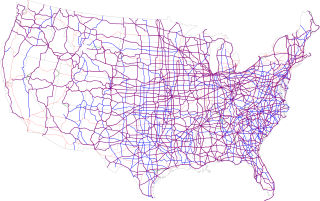
The United States Numbered Highway System is an integrated network of roads and highways numbered within a nationwide grid in the contiguous United States. As the designation and numbering of these highways were coordinated among the states, they are sometimes called Federal Highways, but the roadways were built and have always been maintained by state or local governments since their initial designation in 1926.
A routenumber, designation or abbreviation is an identifying numeric designation assigned by a highway authority to a particular stretch of roadway to distinguish it from other routes and, in many cases, also to indicate its classification, general geographical location and/or orientation. The numbers chosen may be used solely for internal administrative purposes; however, in most cases they are also displayed on roadside signage and indicated on maps.
In the U.S. state of New Jersey, county routes exist in all 21 counties. They are typically the fourth type of roadway classified below the Interstate Highway, the U.S. Route numbered highway and the state highway. The County Route system is defined by two types in New Jersey. First, 500 Series County Routes, also called state secondary routes, are county highways numbered in a statewide system with three-digit numbers that begin with 5. These roads form a second network of routes that supplement the facilitation of the State Routes. Each 500 Series route is unique and is not permitted to be duplicated in another county for a separate route. The second category is defined as Non-500 Series County Routes. Non-500 Series County Routes include 1-digit, 2-digit, 600 Series, 700 Series and 800 Series. These, by definition, are discontinuous across county borders and must be contained entirely within that county. Unlike 500 Series County routes, these route numbers are unique to each county, and are typically assigned to more local routes than the statewide 500-series county route system. They are typically of a lesser classification of streets like minor arterials or collector roadways rather than major arterials or thoroughfares. In the counties that use 600-series numbers, the selection of this range was coordinated within the state, gradually replacing older systems of mainly one- and two-digit routes.
A county highway is a road in the United States and in the Canadian province of Ontario that is designated and/or maintained by the county highway department. Route numbering can be determined by each county alone, by mutual agreement among counties, or by a statewide pattern.
The Massachusetts State Highway System in the U.S. Commonwealth of Massachusetts is a system of state-numbered routes assigned and marked by the highway division of the Massachusetts Department of Transportation (MassDOT). U.S. Highways and Interstate Highways are included in the system; the only overlaps are with the end-to-end U.S. Route 3 and Route 3 and the far-apart Interstate 295, shared with Rhode Island, and Route 295, shared with New York State. A state highway in Massachusetts is a road maintained by the state, which may or may not have a number. Not all numbered routes are maintained or owned by the state.
The New Hampshire Highway System is the public roads system of the U.S. state of New Hampshire containing approximately 17,029 miles (27,406 km) maintained by the New Hampshire Department of Transportation (NHDOT). All public roads in the state are called "highways", thus there is no technical distinction between a "road" or a "highway" in New Hampshire.
In the U.S. state of New York, county routes exist in all 62 counties except those in the five boroughs of New York City. Most are maintained locally by county highway departments. County route designations are assigned at the county level; as a result, routes often change numbers as they cross from one county to the next due to the lack of a statewide numbering system and lack of coordination between counties. Some exceptions exist, such as County Route 36 (CR 36) in Ontario County and CR 36A in Livingston County. The assignment of routes by individual counties also results in varying system density and numbering and signage practices between the state's counties.
Exit numbers in the United States are assigned to freeway junctions, and are usually numbered as exits from freeways. Exit numbers generally are found above the destinations and route number(s) at the exit, as well as a sign in the gore. Exit numbers typically reset at political borders such as state lines. Some major streets also use exit numbers. Freeway exits in the United States are usually numbered in two formats: distance-based and sequential.
In the U.S. state of Pennsylvania, state highways are generally maintained by the Pennsylvania Department of Transportation (PennDOT). Each is assigned a four-digit State Route (SR) number in the present Location Referencing System. Traffic Routes are signed as Interstate Highways, U.S. Routes and Pennsylvania Routes, and are prefixed with one to three zeroes to give a four-digit number. PA Routes are also called Pennsylvania Traffic Routes, and formerly State Highway Routes.
U.S. Route 44 (US 44) is an east–west United States Numbered Highway that runs for 237 miles (381 km) through four states in the Northeastern United States. The western terminus is at US 209 and New York State Route 55 (NY 55) in Kerhonkson, New York, a hamlet in the Hudson Valley region. The eastern terminus is at Route 3A in Plymouth, Massachusetts.