List of crossings of the Chao Phraya River

Last updated

The Chao Phraya River in Bangkok Chao Phraya River in central Bangkok, Thailand.jpg
The Chao Phraya River in Bangkok

The Chao Phraya River flows through Central Thailand from the confluence of the Ping and Nan Rivers in Nakhon Sawan Province southward to its mouth in Samut Prakan Province, where it drains into the Gulf of Thailand. The river has long served as an important channel of water transport, although it was only after the opening of Rama VI Bridge in 1927 that a permanent land transport structure existed over the river. This page lists permanent crossings of the Chao Phraya, starting from the river mouth and continuing upstream to its source.

Contents

List

CrossingDate openedPhotoTypeTotal length
(m)
LocationCoordinatesNotes
Samut Prakan Province
Kanchanaphisek Bridge 2007 Kanchanaphisek bridge 01.JPG Cable-stayed bridge 951 m Phra Pradaeng District, Samut Prakan 13°38′05″N100°32′15″E / 13.634831°N 100.537477°E / 13.634831; 100.537477 The bridge was designed by Parsons Brinckerhoff. The bridge is part of the Kanchanaphisek Expressway, thus there is a toll for its use.
Bhumibol 2 Bridge 2006 Chao Phraya Phra Pradaeng Mega Bridge 2-edit.jpg Cable-stayed bridge 582mPhra Pradaeng District, Samut Prakan 13°39′55″N100°32′22″E / 13.66528°N 100.53944°E / 13.66528; 100.53944 The unofficial name "Mega Bridge" was also widely used.
Bangkok
Bhumibol 1 Bridge 2006 Chao Phraya Phra Pradaeng Mega Bridge 1.jpg Cable-stayed bridge 702m Yan Nawa District, Bangkok, and Phra Pradaeng District, Samut Prakan 13°39′55″N100°32′22″E / 13.66528°N 100.53944°E / 13.66528; 100.53944 The unofficial name "Mega Bridge" was also widely used.
Rama IX Bridge 1987 Rama IX Bridge-2.jpg Cable-stayed bridge 781.20 m Rat Burana and Yan Nawa Districts, Bangkok 13°40′55″N100°31′08″E / 13.682058°N 100.519001°E / 13.682058; 100.519001 
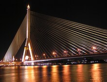
The bridge was named in honour of King Bhumibol Adulyadej's 60th birthday; the opening date coincides with the King's birthday. It was the first cable-stayed bridge in Thailand and had the second longest cable-stayed span in the world when it opened in 1987.
Krungthep Bridge 1959 saphaankrungethph (Krung Thep Bridge) 1.jpg Bascule bridge
Truss bridge
626.25 m Thonburi and Bang Kho Laem Districts, Bangkok 13°42′4″N100°29′30″E / 13.70111°N 100.49167°E / 13.70111; 100.49167 Constructed by Fuji Car Manufacturing Co., Ltd, with a budget of 31,912,500 baht.
Rama III Bridge 1999 Chaophraya so beautiful (11102101454).jpg Box girder bridge 2,170 mThonburi and Bang Kho Laem Districts, Bangkok 13°42′05″N100°29′33″E / 13.701519°N 100.492619°E / 13.701519; 100.492619 Designed to alleviate traffic congestion on the adjacent Krungthep Bridge. Known as the New Krungthep Bridge.
Taksin Bridge 1982 Bangkok - panoramio - Anil Kaushik (1).jpg Box girder bridge 1,791 m Khlong San, Bang Rak, and Sathon Districts, Bangkok 13°43′08″N100°30′45″E / 13.718791°N 100.512543°E / 13.718791; 100.512543 The bridge was designed with a large gap between opposing traffic directions to accommodate a canceled mass transit system. The disused foundations were eventually adapted for the BTS Skytrain, with train services across the bridge beginning on 15 May 2009.
Phra Pok Klao Bridge 1984 Phra Phuttha Yodfa Bridge, Bangkok.jpg Box girder bridge 745 m Phra Nakhon and Khlong San Districts, Bangkok 13°44′20″N100°29′56″E / 13.738999°N 100.498981°E / 13.738999; 100.498981 The bridge was designed to alleviate traffic congestion on the adjacent Memorial Bridge. The bridge is composed of 3 viaducts, with the central viaduct designed to carry future mass transit links. As of December 2007 there are no plans to use the central viaduct.
Memorial Bridge 1932 Phra Phuttha Yodfa Bridge Pano.jpg Truss bridge 678 mPhra Nakhon and Thonburi Districts, Bangkok 13°44′21″N100°29′51″E / 13.73917°N 100.49750°E / 13.73917; 100.49750 Most commonly known as Phra Phutthayotfa Bridge (สะพานพระพุทธยอดฟ้า), after King Phra Phutthayotfa Chulalok (Rama I), the first king of the Chakri Dynasty.
MRT Blue Line tunnel2019 No image.png Rail tunnel  ??Phra Nakhon and Bangkok Yai Districts, BangkokBetween Sanam Chai and Itsaraphap MRT stations. It is the only railway tunnel under a river in Thailand
Phra Pin Klao Bridge 1973 Chao praya river and the bangkok sky.jpg Box girder bridge 658 mNear the Grand Palace
Phra Nakhon and Bangkok Noi Districts, Bangkok
13°45′43″N100°29′28″E / 13.76194°N 100.49111°E / 13.76194; 100.49111 Named after Pinklao, vice-king of Siam 1851-66.
Rama VIII Bridge 2002 Rama VIII Bridge at night.jpg Cable-stayed bridge 475 mPhra Nakhon and Bang Phlat Districts, Bangkok 13°46′9″N100°29′48.5″E / 13.76917°N 100.496806°E / 13.76917; 100.496806 The world's largest asymmetric cable-stayed bridges. The bridge was designed to alleviate traffic congestion on the adjacent Phra Pin-klao Bridge and Krung Thon Bridge.
Krung Thon Bridge 1958 saphaankrungthnburii ekhtdusit krungethphmhaankhr (3).jpg Truss bridge 648.90 m Dusit and Bang Phlat Districts, Bangkok 13°46′51″N100°30′11″E / 13.780892°N 100.502951°E / 13.780892; 100.502951 Known as Sang Hi Bridge
MRT Blue Line bridge2019 No image.png Box girder bridge  ?? Bang Sue and Bang Phlat Districts, BangkokBetween Bang Pho and Bang O MRT stations.
Prachim Ratthaya Expressway 2016 Bang Sue and Bang Phlat Districts, Bangkok
Rama VI Bridge 1927 Rama 6 bridge.JPG Truss bridge 441.44 mBang Sue and Bang Phlat Districts, Bangkok 13°48′47″N100°30′57″E / 13.813108°N 100.515826°E / 13.813108; 100.515826 Railway bridge of the southern line between Bang Son (ground-level) and Bang Bamru stations. Was a mixed railway-road bridge in the past.
Nonthaburi Province
Light Red Line commuter railway bridge2012 No image.png Box girder bridge  ?? Bang Sue, and Bang Kruai District, Nonthaburi 13°48′47″N100°30′57″E / 13.813108°N 100.515826°E / 13.813108; 100.515826 Between Bang Son (elevated) and Bang Bamru stations. Running parallel to Rama VI Bridge
Rama VII Bridge 1992 Rama VII Bridge (downstream, west bank of Chao Phraya River).JPG Box girder bridge 933.19 mBang Sue District, Bangkok, and Bang Kruai District, Nonthaburi 13°48′50″N100°30′52″E / 13.813775°N 100.514442°E / 13.813775; 100.514442
Maha Chesadabodindranusorn Bridge 2015 Bridge at Nonthaburi 1 Road.jpg Extradosed bridge 460 m Mueang Nonthaburi District, Nonthaburi 13°51′16″N100°28′47″E / 13.854331°N 100.479841°E / 13.854331; 100.479841
Rama V Bridge 2002 Box girder bridge 430 mMueang Nonthaburi District 13°49′57″N100°29′43″E / 13.832496°N 100.495312°E / 13.832496; 100.495312
MRT Purple Line bridge2006 No image.png Box girder bridge 400 mMueang Nonthaburi District 13°52′12″N100°28′35″E / 13.87011°N 100.47647°E / 13.87011; 100.47647 Between Phra Nang Klao Bridge and Sai Ma MRT stations. Adjacent to Phra Nang Klao Bridge.
Phra Nang Klao Bridge 1985 New Pranangklao Bridge.jpg Box girder bridge 329.10 mMueang Nonthaburi District 13°52′13″N100°28′34″E / 13.870362°N 100.476194°E / 13.870362; 100.476194
Phra Nang Klao Parallel Bridge 2008 New Pranangklao Bridge.jpg Box girder bridge 299.10 mMueang Nonthaburi District 13°52′17″N100°28′34″E / 13.871497°N 100.476215°E / 13.871497; 100.476215 Running parallel to Phra Nang Klao Bridge.
Rama IV Bridge 2006 Rama 4 bridge.JPG Box girder bridge 278 m Pak Kret District, Nonthaburi 13°54′57″N100°29′38″E / 13.915802°N 100.493875°E / 13.915802; 100.493875
Pathum Thani Province
Nonthaburi Bridge 1959 No image.png Truss bridge 260.20 m Mueang Pathum Thani District, Pathum Thani, and Pakkret District, Nonthaburi 13°56′52″N100°32′06″E / 13.947656°N 100.535052°E / 13.947656; 100.535052 Known as Nuan Chawi Bridge.
Pathum Thani 2 Bridge 2009 Box girder bridge 278.10 mMueang Pathum Thani District 13°57′50″N100°32′10″E / 13.96383°N 100.536°E / 13.96383; 100.536
Pathum Thani Bridge 1984 Box girder bridge 239.10 mMueang Pathum Thani District 14°01′34″N100°32′20″E / 14.02609°N 100.53882°E / 14.02609; 100.53882
Phra Nakhon Si Ayutthaya Province
Chiang Rak Bridge  ?? Box girder bridge  ??Bang Sai District, Phra Nakhon Si Ayutthaya, and Sam Khok District, Pathum Thani
Ko Koet Bridge  ?? No image.png Box girder bridge  ??Bang Pa-in District, Phra Nakhon Si Ayutthaya
Ko Rian Bridge  ?? No image.png Box girder bridge  ??Phra Nakhon Si Ayutthaya District, Phra Nakhon Si Ayutthaya
Kasattrathirat Bridge  ?? Chao Phraya 01.JPG Roving bridge  ??Phra Nakhon Si Ayutthaya District, Phra Nakhon Si Ayutthaya
Ayutthaya–Phukhao Thong Bridge  ?? No image.png Box girder bridge  ??Phra Nakhon Si Ayutthaya District, Phra Nakhon Si Ayutthaya
Chula Mani Bridge Under construction No image.png Box girder bridge  ??Bang Ban District, Phra Nakhon Si Ayutthaya
Ang Thong Province
Pa Mok Bridge  ?? No image.png Box girder bridge  ??Pa Mok District, Ang Thong
Liang Mueang Ang Thong Bridge  ?? No image.png Box girder bridge  ??Mueang District, Ang Thong
Ang Thong Bridge  ?? No image.png Box girder bridge  ??Mueang District, Ang Thong
Phra Maha Phutthaphim 1 Bridge  ?? No image.png Box girder bridge  ??Chaiyo District, Ang Thong
Sing Buri Province
Phrom Buri Bridge  ?? No image.png Box girder bridge  ??Phrom Buri District, Sing Buri
Anuson 100 Pi Sing Buri (Luang Pho Phae 99) Bridge  ?? No image.png Box girder bridge  ??Mueang District, Sing Buri
Sing Buri Bridge  ?? No image.png Box girder bridge  ??Mueang District, Sing Buri
In Buri Bridge  ?? No image.png Box girder bridge  ??In Buri District, Sing Buri
Chai Nat Province
Sapphaya Bridge  ?? No image.png Box girder bridge  ??Sapphaya District, Chai Nat
Chao Phraya Dam 1957 Chaophraya Staudamm 2.jpg Barrage dam 237.5 mSapphaya District, Chai Nat 15°09′29″N100°10′48″E / 15.158°N 100.180°E / 15.158; 100.180
Chai Nat Bridge  ?? No image.png Box girder bridge  ??Mueang Chai Nat District, Chai Nat
Thammajak Bridge 2018 No image.png Box girder bridge  ??Mueang Chai Nat District, Chai NatConnects Tambon Tha Chai with central municipal area. Construction cost: 510 million baht. [1]
Nakhon Sawan Province
Somdet Phra Wannarat (Heng Khemachari) Bridge 1995 No image.png Box girder bridge  ??Phayuha Khiri District, Nakhon Sawan
Takhian Luean Bridge  ?? No image.png Box girder bridge  ??Mueang Nakhon Sawan District, Nakhon Sawan
Dechatiwong 2 Bridge 1971 No image.png Box girder bridge  ??Mueang Nakhon Sawan District, Nakhon Sawan 15°41′18″N100°07′25″E / 15.688257°N 100.123594°E / 15.688257; 100.123594
Dechatiwong 1 Bridge 1950 No image.png Tied-arch bridge  ??Mueang Nakhon Sawan District, Nakhon Sawan 15°41′18″N100°07′25″E / 15.688257°N 100.123594°E / 15.688257; 100.123594 Closed for memorial. Open only emergency situation.
Dechatiwong 3 Bridge 1993 No image.png Box girder bridge  ??Mueang Nakhon Sawan District, Nakhon Sawan 15°41′18″N100°07′25″E / 15.688257°N 100.123594°E / 15.688257; 100.123594

See also

Related Research Articles

<span class="mw-page-title-main">Geography of Thailand</span>

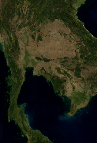
Thailand is in the middle of mainland Southeast Asia. It has a total size of 513,120 km2 (198,120 sq mi) which is the 50th largest in the world. The land border is 4,863 km (3,022 mi) long with Myanmar, Cambodia, Laos and Malaysia. The nation's axial position influenced many aspects of Thailand's society and culture. It controls the only land route from Asia to Malaysia and Singapore. It has an exclusive economic zone of 299,397 km2 (115,598 sq mi).

<span class="mw-page-title-main">Chao Phraya River</span> Major river in Thailand

The Chao Phraya is the major river in Thailand, with its low alluvial plain forming the centre of the country. It flows through Bangkok and then into the Gulf of Thailand.

<span class="mw-page-title-main">Northern Thailand</span> Region in Chiang Mai


Northern Thailand, or more specifically Lanna, is geographically characterised by several mountain ranges, which continue from the Shan Hills in bordering Myanmar to Laos, and the river valleys which cut through them. Though like most of Thailand, it has a tropical savanna climate, its relatively high elevation and latitude contribute to more pronounced seasonal temperature variation, with cooler winters than the other regions.

<span class="mw-page-title-main">Wang River</span> River in Lampang Province, Thailand

The Wang River is a river in northern Thailand.

<span class="mw-page-title-main">Ping River</span> Major Tributary of the Chao Phraya River

The Ping River, along with the Nan River, is one of the two main tributaries of the Chao Phraya River. It originates at Doi Thuai in the Daen Lao Range, in Chiang Dao district, Chiang Mai province. After passing Chiang Mai, it flows through the provinces of Lamphun, Tak, and Kamphaeng Phet. At the confluence with the Nan River at Nakhon Sawan, it forms the Chao Phraya River.

<span class="mw-page-title-main">Nan River</span> Mahor tributary of the Chao Phraya River

The Nan River is a river in Thailand. It is one of the most important tributaries of the Chao Phraya River.

<span class="mw-page-title-main">Yom River</span> River in Thailand

The Yom River is a river in Thailand. It is the main tributary of the Nan River. The Yom River has its source in the Phi Pan Nam Range in Pong District, Phayao Province. Leaving Phayao, it flows through Phrae and Sukhothai as the main water resource of both provinces before it joins the Nan River at Chum Saeng District, Nakhon Sawan Province.

<span class="mw-page-title-main">River systems of Thailand</span>

Thailand has 22 river basins with 254 sub-basins. Rainwater is one of the most important sources of water. Thailand's water resource per capita is less than that of other countries in the region.

<span class="mw-page-title-main">Kanchanaphisek Bridge</span> Bridge in Samut Prakan, Thailand

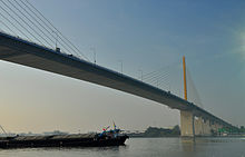
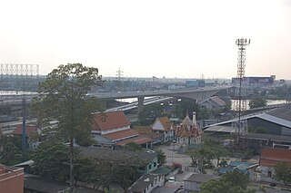
The Kanchanaphisek Bridge is a cable stayed bridge crossing the Chao Phraya river in Samut Prakan Province, Thailand. It is part of the Outer Ring Road encircling Bangkok. The bridge was opened to traffic on 15 November 2007 and has a main span of 500 meters. The name of the bridge comes from the Thai word for the ceremony celebrating the 50th anniversary of the accession of King Bhumibol Adulyadej. The bridge is 52 meters above sea level to allow cargo vessels to enter and exit. The bridge is the first bridge in Samut Prakan Province across over the Chao Phraya River that connect Phra Pradaeng District on the east and west side.

<span class="mw-page-title-main">Ko Kret</span>

<span class="mw-page-title-main">Wongwian Yai</span>

Wongwian Yai, also spelled "Wong Wian Yai" or "Wongwien Yai", is a large roundabout in Thonburi, on the west bank of the Chao Phraya River in Bangkok, Thailand, where the statue of King Taksin is situated.

<span class="mw-page-title-main">Bhumibol Dam</span> Dam in Sam Ngao, Tak

The Bhumibol Dam is a concrete arch dam on the Ping River, a tributary of the Chao Phraya River, in Sam Ngao District of Tak Province, Thailand. It is about 480 km (298 mi) north of Bangkok and was built for the purposes of water storage, hydroelectric power production, flood control, fisheries and saltwater intrusion management. The dam was named after King Bhumibol Adulyadej and it was Thailand's first multi-purpose project. It is the highest dam in Thailand at 154 m (505 ft) tall.

<span class="mw-page-title-main">Sirikit Dam</span> Dam in Tha Pla, Uttaradit

The Queen Sirikit Dam is an embankment dam on the Nan River, a tributary of the Chao Phraya River, in Tha Pla District, Uttaradit Province, Thailand. It is at the southeastern edge of the Phi Pan Nam Range. The dam was built for the purpose of irrigation, flood control and hydroelectric power production. It is named after Sirikit, Queen of Thailand.

Pak Kret is a city in Nonthaburi province, Thailand. It lies in the Central Thai plains on the east bank of the lower Chao Phraya River, bordering Bangkok to the east, Mueang Nonthaburi district of Nonthaburi province to the south, and Pathum Thani province to the north. It is part of the Bangkok Metropolitan Region megalopolis. With a registered population of 190,272, Pak Kret is the third most populous city municipality in Thailand.

Several space objects and features have been named after Thai people or things in Thailand. These include planetary features on Mars and Venus, asteroids and exoplanets.

<span class="mw-page-title-main">Phra Nang Klao Bridge</span> Bridge in Thailand

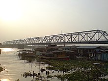
Phra Nang Klao Bridge is a bridge over Chao Phraya River in the area of Mueang Nonthaburi District, Nonthaburi Province.

Khung Samphao is a tambon (sub-district) of Manorom District, north of Chai Nat Province, central Thailand. It is a location of district office.

References

  1. "New Chao Phraya Bridge Opens". Bangkok Post. 16 May 2018. Retrieved 16 May 2018.