This article concerns the systems of transportation in Laos. Laos is a country in Asia, which possesses a number of modern transportation systems, including several highways and a number of airports. As a landlocked country, Laos possesses no ports or harbours on the sea, and the difficulty of navigation on the Mekong means that this is also not a significant transport route.

The Mekong or Mekong River is a transboundary river in East Asia and Southeast Asia. It is the world's twelfth-longest river and the third-longest in Asia with an estimated length of 4,909 km (3,050 mi) and a drainage area of 795,000 km2 (307,000 sq mi), discharging 475 km3 (114 cu mi) of water annually. From its headwaters in the Tibetan Plateau, the river runs through Southwest China, Myanmar, Laos, Thailand, Cambodia, and southern Vietnam. The extreme seasonal variations in flow and the presence of rapids and waterfalls in the Mekong make navigation difficult. Even so, the river is a major trade route between Tibet and Southeast Asia. The construction of hydroelectric dams along the Mekong in the 2000s through the 2020s has caused serious problems for the river's ecosystem, including the exacerbation of drought.

The Red River, also known as the Hong River and Sông Cái in Vietnamese, and the Yuan River in Chinese, is a 1,149-kilometer (714 mi)-long river that flows from Yunnan in Southwest China through northern Vietnam to the Gulf of Tonkin. According to C. Michael Hogan, the associated Red River Fault was instrumental in forming the entire South China Sea at least as early as 37 million years before present. The name red and southern position in China are associated in traditional cardinal directions. The river is relatively shallow, and carries a lot of reddish silt along its way, appearing red brown in colour.

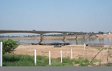
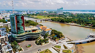
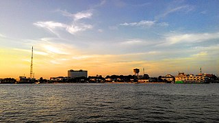
Pakse is the capital and most populous city of the southern Laotian province of Champasak. Located at the confluence of the Xe Don and Mekong Rivers, the district had a population of approximately 77,900 at the 2015 Laotian census. Pakse was the capital of the Kingdom of Champasak until it was unified with the rest of Laos in 1946.
Articles related to Vietnam and Vietnamese culture include:
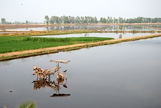
The Mekong Delta, also known as the Western Region or South-western region, is the region in southwestern Vietnam where the Mekong River approaches and empties into the sea through a network of distributaries. The Mekong delta region encompasses a large portion of south-western Vietnam of over 40,500 km2 (15,600 sq mi). The size of the area covered by water depends on the season. Its wet coastal geography makes it an important source of agriculture and aquaculture for the country.
Cần Thơ, anglicized as Can Tho or Cantho, is the fourth-largest city in Vietnam, and the largest city along the Mekong Delta region in Vietnam. It is noted for its floating markets, rice paper-making village, and picturesque rural canals. It has a population of around 1,507,187 as of 2024, and is located on the south bank of the Hậu River, a distributary of the Mekong River.

Tiền Giang is a province in the Mekong Delta region of southern Vietnam.
Mỹ Tho is a city in the Tiền Giang province in the Mekong Delta region of South Vietnam. It has a population of approximately 169,000 in 2006 and 220,000 in 2012. It is the regional center of economics, education and technology. The majority ethnic group is the Kinh; minority groups include the Hoa, the Cham and the Khmer people. Boat rides on the Mỹ Tho River are popular with tourists, and the city is known for hủ tiếu Mỹ Tho, a type of rice noodles soup.

The Bassac River or Hậu River is a distributary of the Tonlé Sap and Mekong River. The river starts in Phnom Penh, Cambodia, and flows southerly, crossing the border into Vietnam near Châu Đốc. The name Bassac comes from the Khmer prefix pa added to sak (សក្តិ), a Khmer word borrowed from the Sanskrit sakti (शक्ति).

Phú Tân is a rural district (huyện) of An Giang province in the Mekong Delta region of Vietnam. As of 2019 the district had a population of 188,951. The district covers an area of 307 km². The district capital lies at Phú Mỹ.

Lakhonepheng is a district (muang) of Salavan province in southern Laos. Lakhonepheng borders the districts of Khongxedone and Vapy in Salavan province to its south and east, Thapangthong and Songkhone districts in Savannakhet province to its north; it also borders the Mekong River which separates it from Ubom Ratcha province in Thailand in its west.

The transport infrastructure of Yunnan is served by numerous transport modes, and forms an integral part of the structure Yunnan Province and the Southwest of China. Yunnan is served by several civilian airports and a major highway and rail network. The province is served by a network of bus routes that radiates from the capital city, Kunming.

Asian Highway 3 (AH3) is a route of the Asian Highway Network which runs 7,331 km (4,555 mi) from Ulan-Ude, Russia to Tanggu, China; and Shanghai, China to Chiang Rai, Thailand and Kengtung, Myanmar.

Champasak is a province in southwestern Laos, near the borders with Thailand and Cambodia. It is one of the three principalities that succeeded the Lao kingdom of Lan Xang. As of the 2015 census, it had a population of 694,023. The capital is Pakse, but the province takes its name from Champasak, the former capital of the Kingdom of Champasak.

The Tiền River is the name given to the section of the Mekong’s mainstream in Vietnam.

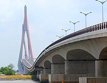
The Vàm Cống Bridge is a road bridge over the Hậu Giang River, a distributary of the Mekong River, in the city of Long Xuyên in Vietnam.