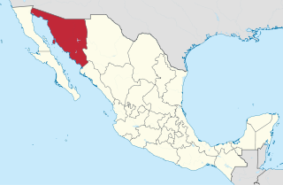
Sonora, officially Estado Libre y Soberano de Sonora, is one of the 31 states which, along with Mexico City, comprise the Federal Entities of Mexico. The state is divided into 72 municipalities; the capital city of which being Hermosillo, located in the center of the state. Other large cities include Ciudad Obregón, Nogales, San Luis Río Colorado, and Navojoa.

Hermosillo, formerly called Pitic, is a city located in the center of the northwestern Mexican state of Sonora. It is the municipal seat of the Hermosillo municipality, the state's capital and largest city, as well as the primary economic center for the state and the region. As of 2020, the city has a population of 936,263, making it the 18th largest city in Mexico. The recent increase in the city's population is due to expanded industrialization, especially within the automotive industry.

Puerto Peñasco is a small city located in Puerto Peñasco Municipality in the northwest of the Mexican state of Sonora, 100 kilometres (62 mi) from the border with the U.S. state of Arizona. According to the 2020 census, it has a population of 62,689 inhabitants. It is located on the northern shores of the Sea of Cortez on the small strip of land that joins the Baja California Peninsula with the rest of Mexico. The area is part of the Altar Desert, one of the driest and hottest areas of the larger Sonoran Desert.

Ahome is a municipality on the coast of the Gulf of California in the northwestern part of the Mexican state of Sinaloa; it is adjacent to the southern border of Sonora state. It reported 388,344 inhabitants in the 2005 census. Ahome is also the name of the second-largest community in the municipality. The municipal seat is the port city of Los Mochis, its largest community. It is a commercial corridor to the northwest of the country. It is situated on the Pacific coastal plain, at the entrance of the Gulf of California and lies in the heart of a rich agricultural region, Fort Valley. It stands at 25°33′50″N108°46′00″W.

Guaymas is a city in Guaymas Municipality, in the southwest part of the state of Sonora, in northwestern Mexico. The city is 134 kilometres (83 mi) south of the state capital of Hermosillo, and 389 kilometres (242 mi) from the U.S. border. The municipality's formal name is Guaymas de Zaragoza and the city's formal name is the Heroica Ciudad de Guaymas.

San Carlos is a beachfront subdivision within the port city of Guaymas, but is considered its own town in the northern state of Sonora in Mexico. It is known for the clarity and warmth of the ocean water in its shallow bays. It lies on the Sea of Cortez. Given the size of the city, with nearly 7,000 inhabitants, there is a large number of RV parks, resorts and stores available. There is also an active diving community. Many Americans and Canadians live in San Carlos during the winter months. The summer months are very hot and humid. Fishing, scuba dive, and beach activities can be pursued here. Another widespread sport in San Carlos is sailing but you can also decide to skydive over the Sea of Cortez.

The Spanish missions in the Sonoran Desert are a series of Jesuit Catholic religious outposts established by the Spanish Catholic Jesuits and other orders for religious conversions of the Pima and Tohono O'odham indigenous peoples residing in the Sonoran Desert. An added goal was giving Spain a colonial presence in their frontier territory of the Sonora y Sinaloa Province in the Viceroyalty of New Spain, and relocating by Indian Reductions settlements and encomiendas for agricultural, ranching, and mining labor.

Bahía Kino is a town part of the Hermosillo Municipality in Sonora, Mexico on the Gulf of California; it was named after Eusebio Kino. It has a population of approximately 7,000 people. The name also applies to the adjacent bay between Tiburón Island and Punta San Nicolás, Sonora. The names Bahía de Kino, Bahía Kino and Kino Bay are used interchangeably.

Hurricane Isis was the only hurricane to make landfall during the 1998 Pacific hurricane season. The ninth tropical storm and sixth hurricane of the season, Isis developed on September 1 from an interaction between a tropical wave and a large surface circulation to the southwest of Mexico. It moved northward, striking the extreme southeastern portion of the Baja California peninsula before attaining hurricane status in the Gulf of California. Isis made landfall at Topolobampo in the Mexican state of Sinaloa on September 3, and quickly lost its low-level circulation. The remnants persisted for several days before dissipating over the U.S. state of Idaho on September 8.

Los Mochis is a coastal city in northern Sinaloa, Mexico. It serves as the municipal seat of the municipality of Ahome. As of the 2010 census, the population was 362,613, which was 61 percent of the municipality's population.
MVS Radio are a group of four international Spanish-language radio networks owned by the mass media conglomerate MVS Comunicaciones. The group of radio networks consists of Exa FM, La Mejor, Globo and MVS Noticias and are broadcast in a various Latin American countries including Argentina, Costa Rica, Dominican Republic, Ecuador, El Salvador, Guatemala, Honduras, Mexico and the United States.
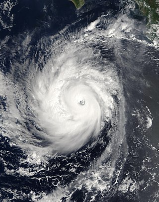
Hurricane Norbert is tied with Hurricane Jimena as the strongest tropical cyclone to strike the west coast of Baja California Sur in recorded history. The fifteenth named storm, seventh hurricane, and second major hurricane of the 2008 hurricane season, Norbert originated as a tropical depression from a tropical wave south of Acapulco on October 3. Strong wind shear initially prevented much development, but the cyclone encountered a more favorable environment as it moved westward. On October 5, the National Hurricane Center (NHC) upgraded the depression to Tropical Storm Norbert, and the system intensified further to attain hurricane intensity by October 6. After undergoing a period of rapid deepening, Norbert reached its peak intensity as a Category 4 on the Saffir–Simpson hurricane wind scale, with maximum sustained winds of 135 mph (217 km/h) and a minimum barometric pressure of 945 mbar. As the cyclone rounded the western periphery of a subtropical ridge over Mexico, it began an eyewall replacement cycle which led to steady weakening. Completing this cycle and briefly reintensifying into a major hurricane, a Category 3 or higher on the Saffir–Simpson hurricane wind scale, Norbert moved ashore Baja California Sur as a Category 2 hurricane late on October 11. After a second landfall at a weaker intensity the following day, the system quickly weakened over land and dissipated that afternoon.
The following television stations broadcast on digital channel 21 in Mexico:
Federal Highway 15D is the name for toll highways paralleling Federal Highway 15. The toll segments of Highway 15D include some of the most significant highways in the country along the Nogales-Mexico City corridor. The highway is the southern terminus of the CANAMEX Corridor, a trade corridor that stretches from Mexico north across the United States to the Canadian province of Alberta.

Tropical Storm Lidia was a large tropical cyclone that caused flooding in Baja California Peninsula and parts of western Mexico. The fourteenth tropical cyclone and twelfth named storm of the 2017 Pacific hurricane season, Lidia developed from a large area of disturbed weather west of the Pacific Coast of Mexico on August 31. The storm intensified while moving generally northward or northwestward, peaking with maximum sustained winds of 65 mph (105 km/h) later that day. On September 1, Lidia made landfall in Mexico near Puerto Chale, Baja California Sur, at peak intensity. The storm weakened while traversing the peninsula, ultimately emerging over the Pacific Ocean on September 3, where the storm degenerated into a remnant low. The system brought thunderstorms and wind gusts to Southern California, before dissipating on September 4.

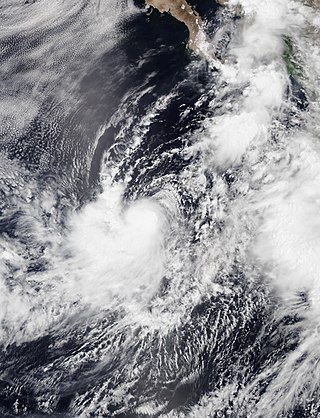
Tropical Depression Nineteen-E was a weak yet costly tropical cyclone that caused significant flooding throughout Northwestern Mexico and several states within the United States in September 2018. The storm was also the first known tropical cyclone to form over the Gulf of California. Nineteen-E originated from a tropical wave that left the west coast of Africa on August 29 to 30. It continued westward, crossed over Central America, and entered the northeastern Pacific Ocean by September 7. It then meandered to the southwest of Mexico for the next several days as it interacted with a mid-to-upper level trough. The National Hurricane Center (NHC) continued to track the disturbance for the next several days as it traveled northward. A surface trough developed over the Baja California peninsula on September 18. Despite disorganization and having close proximity to land, the disturbance developed into a tropical depression in the Gulf of California on September 19, after having developed a circulation center and more concentrated convection. The system peaked with maximum sustained winds of 35 mph (55 km/h) and a minimum central pressure of 1002 mbar.
Tropical Storm Ivo was a tropical cyclone that brought heavy rainfall to five states in Mexico, causing severe flooding during August 2019. The tenth tropical cyclone and ninth named storm of the 2019 Pacific hurricane season, Ivo arose from a low-pressure area that spawned south of Guatemala on August 16. The low-pressure system gradually organized over the next several days as it tracked west-northwestward. The system coalesced into a tropical depression early on August 21 and strengthened into Tropical Storm Ivo several hours later. Located within a favorable environment of moist air and warm sea surface temperatures, the cyclone quickly intensified, peaking the next day with 1-minute maximum sustained winds of 70 mph (110 km/h) and a pressure of 990 mbar (29.23 inHg). Increasing wind shear caused the storm's intensification to level off later that day, as the system turned towards the north-northwest. Ivo passed by Clarion Island midday on August 23, generating winds of 60 mph (100 km/h) on the island. Wind shear caused Ivo to significantly degrade in structure and intensity during the next couple of days. Cold sea surface temperatures, as well as dry and stable air, caused the cyclone to degenerate into a remnant low early on August 25. The low meandered over the eastern Pacific before opening up into a trough of low pressure early on August 27.
Charles Conant Maldonado was a Mexican businessman, colonel, and politician, one of the founders of the Sonora-Sinaloa Irrigation Company (SSIC) along with his brother Joseph Benjamin (Benito) Conant Maldonado and Santos Valenzuela, a businessman from the agricultural town Cócorit, Sonora. In 1883 he was municipal president of Ocampo, Chihuahua, after Sonoran Governor Ignacio Pesqueira banished him from Sonora in 1873, for having taken up arms against him.