Queenstown is a resort town in Otago in the south-west of New Zealand's South Island. It is the seat and largest town in the Queenstown-Lakes District.

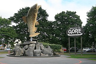
Gore is a town and district in the Southland region of the South Island of New Zealand. It has a resident population of 8,240 as of June 2023. Gore is known for its country music scene and hosts an annual country music festival. The town is also surrounded by farmland and is an important centre for agriculture in the region.

Riverton, officially Riverton / Aparima, is a small New Zealand town 30 kilometres (19 mi) west of Invercargill, on the south-eastern shorelines of the Jacobs River Estuary. The estuary is formed by the Aparima and Pourakino rivers, leading through a narrow outflow channel into Foveaux Strait. Accessible via State Highway 99 on the Southern Scenic Route, the main part of the town is on flat land and the northern end of Oreti Beach. South Riverton is built on the hills between the eastern shore of the estuary and Taramea Bay.

Alexandra is a town in the Central Otago district of the South Island of New Zealand. It is on the banks of the Clutha River, on State Highway 8, 188 kilometres (117 mi) by road from Dunedin and 33 kilometres (21 mi) south of Cromwell. The nearest towns to Alexandra via state highway 8 are Clyde seven kilometres to the northwest and Roxburgh forty kilometres to the south. State highway 85 also connects Alexandra to Omakau, Lauder, Oturehua, Ranfurly and on to Palmerston on the East Otago coast.

Geraldine is a town in the Canterbury region in the South Island of New Zealand. It is about 140 km south of Christchurch, and inland from Timaru, which is 38 km to the south. Geraldine is located on State Highway 79 between the Orari and Hae Hae Te Moana Rivers and 45 kilometres to the east of Fairlie.

Arrowtown is a historic gold mining town in the Otago region of the South Island of New Zealand. Arrowtown is located on the banks of the Arrow River approximately 7.5 km from State Highway 6. Arrowtown is located 19.5 kilometres to the east of Queenstown. As well as the route via State Highway 6 at Arrow Junction, there is also road access directly to Queenstown via Arthurs Point and a third route via the picturesque Lake Hayes.

Southland District is a New Zealand territorial authority district that covers most of the southern end of the South Island as well as Stewart Island.

Lumsden is a town in Southland, New Zealand. Lying in a gap in the surrounding hills, Lumsden is the location of a major junction on State Highway 6. Lumsden is 81 kilometres north of Invercargill, 106 kilometres south of Queenstown, 59 kilometres west of Gore and 77 kilometres east of Te Anau.

Tokanui is a community in the eastern portion of Southland District Council, located on the Southern Scenic Route about 56 km (35 mi) east of Invercargill and 107 km (66 mi) southwest of Balclutha, New Zealand. The Tokanui River runs just to the north of the village and occasionally floods the lower parts, as it did when the railway yard flooded in 1935.

The Clifden Suspension Bridge is a historic suspension bridge near Clifden, New Zealand with a single lane. Built in 1899, it spans the Waiau River and is 111.5 m long.

Otautau is a small farming, forestry and milling town located inland on the western edge of the Southland Plains of New Zealand on the banks of the Aparima River. Otautau is located approximately 40 kilometres (25 mi) north west of Invercargill. The average elevation of Otautau is 60 metres.
Waikaia, formerly known as Switzers, is a town in the Southland region of New Zealand's South Island. From 1909 until 1959, it was the terminus of the Waikaia Branch railway. The population in the 2013 census was 99, unchanged from the previous census in 2006.
John Thomas Mair was a New Zealand architect. From 1923 until his retirement in 1941 he held the position of Government Architect.

Southland is New Zealand's southernmost region. It consists of the southwestern portion of the South Island and includes Stewart Island. Southland is bordered by the culturally similar Otago Region to the north and east, and the West Coast Region in the extreme northwest. The region covers over 3.1 million hectares and spans 3,613 km of coastline. As of June 2023, Southland has a population of 103,900, making it the eleventh-most-populous New Zealand region, and the second-most sparsely populated. Approximately half of the region's population lives in Invercargill, Southland's only city.
Clydevale is a township on the banks of the Clutha River / Mata-Au, in the Clutha Valley, 29 kilometres north-west of Balclutha.

Bainham is a settlement in the Tasman District of New Zealand. Originally called Riverdale, it is located inland from Golden Bay, 14 kilometres (8.7 mi) southwest of Collingwood.


