List of lakes in Teton County, Montana

Last updated
Map all coordinates using: OpenStreetMap  ·  Google Maps
Download coordinates as: KML  ·  GPX

There are at least 30 named lakes and reservoirs in Teton County, Montana .

Lake A body of relatively still water, in a basin surrounded by land

A lake is an area filled with water, localized in a basin, that is surrounded by land, apart from any river or other outlet that serves to feed or drain the lake. Lakes lie on land and are not part of the ocean, and therefore are distinct from lagoons, and are also larger and deeper than ponds, though there are no official or scientific definitions. Lakes can be contrasted with rivers or streams, which are usually flowing. Most lakes are fed and drained by rivers and streams.

Reservoir A storage space for fluids

A reservoir is, most commonly, an enlarged natural or artificial lake, pond or impoundment created using a dam or lock to store water.

Teton County, Montana County in the United States

Teton County is a county in the U.S. state of Montana. As of the 2010 United States Census, the population was 6,073. Its county seat is Choteau. The county was founded in 1893.

Contents

Lakes

Davis Lake lake in Deschutes County, United States of America

Davis Lake straddles the border between Deschutes County and Klamath County in the U.S. state of Oregon. A relatively large and shallow lake in the Deschutes National Forest, it is located toward the south end of the Cascade Lakes Scenic Byway, near Oregon Route 58 and U.S. 97. The lake is known as one of Oregon's best bass lakes.

Reservoirs

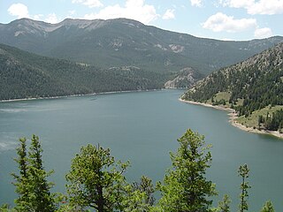
Gibson Reservoir, Montana GibsonR.jpg
Gibson Reservoir, Montana
Gibson Reservoir

Gibson Reservoir is located just south of the Bob Marshall Wilderness in Montana. The reservoir is formed by the concrete arch Gibson Dam and backs water up between a hilly pass for about 3 miles. The water in the dam is initially provided by spring snow runoff and carried there via the North Fork Sun River and the South Fork Sun River right after the two join. The reservoir is mainly used for irrigation control.

See also

Notes

  1. "Basin Lake". Geographic Names Information System . United States Geological Survey.
  2. "Davis Lake". Geographic Names Information System . United States Geological Survey.
  3. "Eyraud Lakes". Geographic Names Information System . United States Geological Survey.
  4. "Freezeout Lake". Geographic Names Information System . United States Geological Survey.
  5. "Glendora Lake". Geographic Names Information System . United States Geological Survey.
  6. "Lake Theboe". Geographic Names Information System . United States Geological Survey.
  7. "Middle Lake". Geographic Names Information System . United States Geological Survey.
  8. "Our Lake". Geographic Names Information System . United States Geological Survey.
  9. "Pond Number Five". Geographic Names Information System . United States Geological Survey.
  10. "Pond Number Four". Geographic Names Information System . United States Geological Survey.
  11. "Pond Number One". Geographic Names Information System . United States Geological Survey.
  12. "Pond Number Six". Geographic Names Information System . United States Geological Survey.
  13. "Pond Number Three". Geographic Names Information System . United States Geological Survey.
  14. "Pond Number Two". Geographic Names Information System . United States Geological Survey.
  15. "Priest Butte Lake". Geographic Names Information System . United States Geological Survey.
  16. "Reickoff Lakes". Geographic Names Information System . United States Geological Survey.
  17. "Round Lake". Geographic Names Information System . United States Geological Survey.
  18. "Split Rock Lake". Geographic Names Information System . United States Geological Survey.
  19. "Tunnel Lake". Geographic Names Information System . United States Geological Survey.
  20. "Twin Lakes". Geographic Names Information System . United States Geological Survey.
  21. "Burd Hill Lake". Geographic Names Information System . United States Geological Survey.
  22. "Bynum Reservoir". Geographic Names Information System . United States Geological Survey.
  23. "Dougcliff Reservoir". Geographic Names Information System . United States Geological Survey.
  24. "Eureka Reservoir". Geographic Names Information System . United States Geological Survey.
  25. "Farmers Reservoir". Geographic Names Information System . United States Geological Survey.
  26. "Gibson Reservoir". Geographic Names Information System . United States Geological Survey.
  27. "Harvey Lake". Geographic Names Information System . United States Geological Survey.
  28. "John Lane Reservoir". Geographic Names Information System . United States Geological Survey.
  29. "Pishkun Reservoir". Geographic Names Information System . United States Geological Survey.
  30. "Theboe Lake". Geographic Names Information System . United States Geological Survey.