Bynum, Montana | |
---|---|
Coordinates: 47°58′05″N112°18′59″W / 47.96806°N 112.31639°W | |
Country | United States |
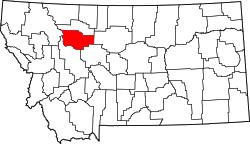
State | Montana |
County | Teton |
Area | |
• Total | 1.63 sq mi (4.22 km2) |
• Land | 1.63 sq mi (4.22 km2) |
• Water | 0.00 sq mi (0.00 km2) |
Elevation | 3,977 ft (1,212 m) |
Population (2020) | |
• Total | 28 |
• Density | 17.20/sq mi (6.64/km2) |
Time zone | UTC-7 (Mountain (MST)) |
• Summer (DST) | UTC-6 (MDT) |
Area code | 406 |
GNIS feature ID | 2583794 [2] |
Bynum is an unincorporated community and census-designated place in Teton County, Montana, United States, approximately 13 miles north of Choteau. Its population was 31 as of the 2010 census. [3]
Bynum is the site of a one-room country school, a general store, post office, an agate shop, and Two Medicine Dinosaur Center, which provides displays and educational programs about dinosaurs.
The town's name is derived from the surname of a family of early settlers in the area. [4] The post office was established in 1885. [5] In 1908 work on the Bynum Reservoir began. [4]
In 2017, the NBC Today Show produced a segment highlighting Bynum's school and its tradition of starting each school day with a song and a dance. [6]
Climate data for Bynum, Montana, 1991–2020 normals | |||||||||||||
---|---|---|---|---|---|---|---|---|---|---|---|---|---|
Month | Jan | Feb | Mar | Apr | May | Jun | Jul | Aug | Sep | Oct | Nov | Dec | Year |
Mean daily maximum °F (°C) | 36.0 (2.2) | 35.8 (2.1) | 43.6 (6.4) | 51.3 (10.7) | 61.6 (16.4) | 70.5 (21.4) | 80.3 (26.8) | 79.3 (26.3) | 69.6 (20.9) | 55.0 (12.8) | 43.0 (6.1) | 34.5 (1.4) | 55.0 (12.8) |
Daily mean °F (°C) | 25.2 (−3.8) | 25.5 (−3.6) | 32.2 (0.1) | 40.3 (4.6) | 50.2 (10.1) | 58.5 (14.7) | 66.2 (19.0) | 65.4 (18.6) | 56.4 (13.6) | 43.5 (6.4) | 33.1 (0.6) | 25.4 (−3.7) | 43.5 (6.4) |
Mean daily minimum °F (°C) | 14.3 (−9.8) | 15.2 (−9.3) | 20.7 (−6.3) | 29.2 (−1.6) | 38.8 (3.8) | 46.5 (8.1) | 52.1 (11.2) | 51.4 (10.8) | 43.2 (6.2) | 32.0 (0.0) | 23.1 (−4.9) | 16.3 (−8.7) | 31.9 (0.0) |
Average precipitation inches (mm) | 0.60 (15) | 0.43 (11) | 1.06 (27) | 2.11 (54) | 2.64 (67) | 2.49 (63) | 1.55 (39) | 1.32 (34) | 1.19 (30) | 1.02 (26) | 0.49 (12) | 0.44 (11) | 15.34 (389) |
Source: NOAA [7] |
Census | Pop. | Note | %± |
---|---|---|---|
2010 | 31 | — | |
2020 | 28 | −9.7% | |
U.S. Decennial Census [8] |
Dillon is a city in and the county seat of Beaverhead County, Montana, United States. The population was 3,880 at the 2020 census. The city was named for Sidney Dillon (1812–1892), president of Union Pacific Railroad.
Ekalaka is a town in and the county seat of Carter County, Montana, United States. The population was 399 at the 2020 census.
Belt is a town in Cascade County, Montana, United States. The population was 510 according to the 2020 census. It is part of the Great Falls, Montana metropolitan area.
Livingston, is a city and county seat of Park County, Montana, United States. It is in southwestern Montana, on the Yellowstone River, north of Yellowstone National Park. As of the 2020 census, the population of the city was 8,040.
Winnett is a town in and the county seat of Petroleum County, Montana, United States. The population was 188 at the 2020 census.
Malta is a city in, and the county seat of, Phillips County, Montana, United States, located at the intersection of U.S. Routes 2 and 191. The population was 1,860 at the 2020 census.
Broadus is a town in and the county seat of Powder River County, Montana, United States. The population was 456 at the 2020 census.
Choteau is a city in and the county seat of Teton County, Montana, United States. The population was 1,721 at the 2020 census.
Fort Peck is a town in Valley County, Montana, United States. The population was 239 at the 2020 census.
Harlowton is a city in and the county seat of Wheatland County, Montana, United States. The population was 955 at the 2020 census.
Stanford is a town in and the county seat of Judith Basin County, Montana, United States. The population was at 403 as of the 2020 census.
Arlee is an unincorporated community and census-designated place (CDP) on the Flathead Reservation, Lake County, Montana, United States. The population was 725 at the 2020 census. It is named after Alee, a Salish chief. The chief's name has no "r", as the Salish alphabet has no letter "r".
Rapelje is an unincorporated community and census-Designated Place in northern Stillwater County, Montana, United States. Rapelje was named for J. M. Rapelje, general manager and vice president of the Northern Pacific Railway. Rapelje had a population of approximately 110 people as of the 2000 census. Rapelje is located 24 miles north of Columbus on Montana Secondary Highway 306.
Twodot or Two Dot is a census-designated place (CDP) in west-central Wheatland County, Montana, United States, along the route of U.S. Route 12.
Turner is a Census-designated place village in Blaine County, Montana, United States. Turner is located on Montana State Highway 241, 41.5 miles (66.8 km) east-northeast of Chinook. It is 12 miles south of the Canadian border. Its population was 61 as of the 2010 census.
Pray is a census-designated place and unincorporated community in Park County, Montana, United States, in the Paradise Valley. The town was founded in 1907 by Valentine Eggar, an entrepreneur. He named it after Congressman Charles Nelson Pray. Its population was 681 as of the 2010 census. Pray has a post office with ZIP code 59065, which opened on December 8, 1909.
Hinsdale is an unincorporated community and census-designated place in Valley County, Montana, United States. The town's population was 217 and the community's population as a whole was 583 as of the 2010 census. The community is located on the Milk River and U.S. Route 2, with Montana Highway 537 headed north out of town and South Bench Road crossing the railroad tracks and running south of town. Hinsdale has a post office with ZIP code 59241.
Whitewater is a census-designated place and unincorporated community in Phillips County, Montana, United States. Its population was 64 as of the 2010 census. Whitewater has a post office with ZIP code 59544.
Brady is a census-designated place and unincorporated community in Pondera County, Montana, United States. Its population was 140 as of the 2010 census. Brady has a post office with ZIP code 59416. The community is located along Interstate 15.
Stockett is a census-designated place and unincorporated community in Cascade County, Montana, United States. Its population was 169 as of the 2010 census. Stockett has a post office with ZIP code 59480.