
Canada has a vast geography that occupies much of the continent of North America, sharing a land border with the contiguous United States to the south and the U.S. state of Alaska to the northwest. Canada stretches from the Atlantic Ocean in the east to the Pacific Ocean in the west; to the north lies the Arctic Ocean. Greenland is to the northeast with a shared border on Hans Island. To the southeast Canada shares a maritime boundary with France's overseas collectivity of Saint Pierre and Miquelon, the last vestige of New France. By total area, Canada is the second-largest country in the world, after Russia. By land area alone, however, Canada ranks fourth, the difference being due to it having the world's largest proportion of fresh water lakes. Of Canada's thirteen provinces and territories, only two are landlocked while the other eleven all directly border one of three oceans.

The Gulf of St. Lawrence fringes the shores of the provinces of Quebec, New Brunswick, Nova Scotia, Prince Edward Island, Newfoundland and Labrador, in Canada, plus the islands Saint-Pierre and Miquelon, possessions of France, in North America.

The Gaspé Peninsula, also known as Gaspesia, is a peninsula along the south shore of the St. Lawrence River that extends from the Matapedia Valley in Quebec, Canada, into the Gulf of St. Lawrence. It is separated from New Brunswick on its southern side by Chaleur Bay and the Restigouche River. The name Gaspé comes from the Mi'kmaq word gespe'g, meaning "end", referring to the end of the land.

The Appalachian Mountains, often called the Appalachians, are a mountain range in eastern to northeastern North America. The term "Appalachian" refers to several different regions associated with the mountain range, and its surrounding terrain. The general definition used is one followed by the United States Geological Survey and the Geological Survey of Canada to describe the respective countries' physiographic regions. The U.S. uses the term Appalachian Highlands and Canada uses the term Appalachian Uplands; the Appalachian Mountains are not synonymous with the Appalachian Plateau, which is one of the provinces of the Appalachian Highlands.

The Labrador Peninsula or Quebec-Labrador Peninsula, is a large peninsula in eastern Canada. It is bounded by Hudson Bay to the west, the Hudson Strait to the north, the Labrador Sea to the east, Strait of Belle Isle and the Gulf of St. Lawrence to the southeast. The peninsula includes the region of Labrador, which is part of the province of Newfoundland and Labrador, and the regions of Saguenay–Lac-Saint-Jean, Côte-Nord, and Nord-du-Québec, which are in the province of Quebec. It has an area of 1,400,000 km2 (541,000 sq mi).

Located in the eastern part of Canada, and part of Central Canada, Quebec occupies a territory nearly three times the size of France or Texas. It is much closer to the size of Alaska. As is the case with Alaska, most of the land in Quebec is very sparsely populated. Its topography is very different from one region to another due to the varying composition of the ground, the climate, and the proximity to water. The Great Lakes–St. Lawrence Lowlands and the Appalachians are the two main topographic regions in southern Quebec, while the Canadian Shield occupies most of central and northern Quebec.

Central Canada is a Canadian region consisting of Ontario and Quebec, the largest and most populous provinces of the country. Geographically, they are not at the centre of Canada but instead overlap with Eastern Canada toward the east. Because of their large populations, Ontario and Quebec have traditionally held a significant amount of political power in Canada, leading to some amount of resentment from other regions of the country. Before Confederation, the term "Canada" specifically referred to Central Canada. Today, the term "Central Canada" is less often used than the names of the individual provinces.

The Laurentian Mountains, also known as the Laurentians or Laurentides, are a mountain range in Canada. The range is 1,448 km long and ranges in height from 500 m with peaks over 1,000 m. The Laurentian Mountains extend across Labrador and Quebec within the Laurentian Upland, which contains foothills in northeastern Ontario. The range is located near the rivers of Ottawa, St. Lawrence, and Saguenay. The Laurentian Mountains primarily stretch across multiple regions in Quebec, with geologic formations such as the Jacques-Cartier Massif located within the range.
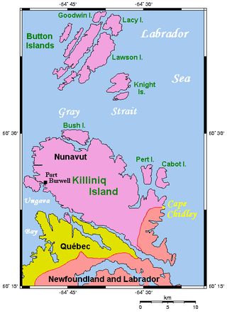
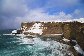
Cape Chidley is a headland located on the eastern shore of Killiniq Island, Canada, at the northeastern tip of the Labrador Peninsula.

The Torngat Mountains are a mountain range on the Labrador Peninsula at the northern tip of Newfoundland and Labrador and eastern Quebec. They are part of the Arctic Cordillera. The mountains form a peninsula that separates Ungava Bay from the Atlantic Ocean.

The International Appalachian Trail was originally a hiking trail which ran from Katahdin Woods and Waters National Monument, in Maine, through New Brunswick, to the Gaspé Peninsula of Quebec, after which it followed a ferry route to Newfoundland, and then continued to the northern-easternmost point of the Appalachian Mountains at Belle Isle, Newfoundland and Labrador. As of July 2020, there are widely geographically dispersed IAT-branded walking trails in Greenland, Iceland, Norway, Sweden, Denmark, Scotland, Northern Ireland, Ireland, Isle of Man, Wales, England, Spain, Portugal, and Morocco.
The Port au Port Peninsula is a peninsula in the Canadian province of Newfoundland and Labrador. Roughly triangular in shape, it is located on the west coast of the island of Newfoundland.

Blanc-Sablon is a municipality located on the shore of Blanc-Sablon Bay, in the Strait of Belle-Isle, Le Golfe-du-Saint-Laurent RCM, Côte-Nord, Quebec, Canada.

Newfoundland and Labrador is the easternmost province in Canada. The Strait of Belle Isle separates the province into two geographical regions, Labrador and the island of Newfoundland. The province also includes over seven thousand small islands.

The Laurentian Channel is a deep submarine valley off the coast of eastern Canada in the Gulf of Saint Lawrence.

The Eastern Canadian Boreal Forests is a boreal ecoregion in Eastern Canada, defined by the One Earth ecoregion categorization system.
Humans have inhabited Quebec for 11,000 years beginning with the de-glaciated areas of the St. Lawrence River valley and expanding into parts of the Canadian Shield after glaciers retreated 5,000 years ago. Quebec has almost universally acidic soils that destroy bone and many other traces of human activity, complicating archaeological research together with development in parts of southern Quebec. Archaeological research only began in earnest in the 1960s and large parts of the province remain poorly researched.

The border between the province of Newfoundland and Labrador and the province of Quebec is the longest interprovincial border in Canada. It stretches for more than 3,500 kilometres (2,200 mi) on land, and, according to both provincial governments, also contains a maritime part. Starting from the north, the border follows the Laurentian Divide on the Labrador Peninsula for the majority of the border's length, then follows the divide between the Côte-Nord-Gaspé and Newfoundland-Labrador drainage basins as far as Brûlé Lake, after which it goes along the Romaine River downstream to the 52nd parallel, which it follows east to its southeastern terminus at Blanc-Sablon.