WikiMili
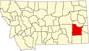
List of mountains in Custer County, Montana
Last updated
March 21, 2022
Map all coordinates using:
OpenStreetMap
Download coordinates as:
KML
This list is
incomplete
; you can help by
adding missing items
.
(
February 2011
)
There are at least
49 named
mountains
in
Custer County, Montana
.
Angelwing Butte
,
46°22′52″N
105°44′01″W
/
46.38111°N 105.73361°W
/
46.38111; -105.73361
(
Angelwing Butte
)
, el.
3,100 feet (940
m)
[1]
Badland Butte
,
46°26′15″N
105°44′04″W
/
46.43750°N 105.73444°W
/
46.43750; -105.73444
(
Badland Butte
)
, el.
2,687 feet (819
m)
[2]
Baldy Butte
,
46°04′56″N
106°09′54″W
/
46.08222°N 106.16500°W
/
46.08222; -106.16500
(
Baldy Butte
)
, el.
3,268 feet (996
m)
[3]
Baldy Butte
,
46°14′31″N
105°09′55″W
/
46.24194°N 105.16528°W
/
46.24194; -105.16528
(
Baldy Butte
)
, el.
3,232 feet (985
m)
[4]
Baldy Peak
,
46°26′06″N
105°25′52″W
/
46.43500°N 105.43111°W
/
46.43500; -105.43111
(
Baldy Peak
)
, el.
3,232 feet (985
m)
[5]
Big Hill
,
46°29′23″N
105°55′05″W
/
46.48972°N 105.91806°W
/
46.48972; -105.91806
(
Big Hill
)
, el.
2,700 feet (820
m)
[6]
Big Peak
,
46°30′42″N
105°25′08″W
/
46.51167°N 105.41889°W
/
46.51167; -105.41889
(
Big Peak
)
, el.
3,153 feet (961
m)
[7]
Blue Mountain
,
46°28′20″N
105°24′45″W
/
46.47222°N 105.41250°W
/
46.47222; -105.41250
(
Blue Mountain
)
, el.
3,287 feet (1,002
m)
[8]
Blue Mountains
,
46°26′50″N
105°24′47″W
/
46.44722°N 105.41306°W
/
46.44722; -105.41306
(
Blue Mountains
)
, el.
3,035 feet (925
m)
[9]
Bracket Butte
,
46°26′55″N
104°57′46″W
/
46.44861°N 104.96278°W
/
46.44861; -104.96278
(
Bracket Butte
)
, el.
3,205 feet (977
m)
[10]
Buck Mountain
,
46°27′43″N
105°26′18″W
/
46.46194°N 105.43833°W
/
46.46194; -105.43833
(
Buck Mountain
)
, el.
3,314 feet (1,010
m)
[11]
Camelsback
,
46°23′04″N
105°51′25″W
/
46.38444°N 105.85694°W
/
46.38444; -105.85694
(
Camelsback
)
, el.
2,490 feet (760
m)
[12]
Carbon Hill
,
46°23′50″N
105°49′06″W
/
46.39722°N 105.81833°W
/
46.39722; -105.81833
(
Carbon Hill
)
, el.
2,526 feet (770
m)
[13]
Chalk Butte
,
46°50′33″N
106°04′43″W
/
46.84250°N 106.07861°W
/
46.84250; -106.07861
(
Chalk Butte
)
, el.
3,028 feet (923
m)
[14]
Chimney Butte
,
45°50′52″N
105°07′34″W
/
45.84778°N 105.12611°W
/
45.84778; -105.12611
(
Chimney Butte
)
, el.
3,300 feet (1,000
m)
[15]
Corral Butte
,
46°31′33″N
105°25′51″W
/
46.52583°N 105.43083°W
/
46.52583; -105.43083
(
Corral Butte
)
, el.
3,018 feet (920
m)
[16]
Dug Long Hill
,
46°12′10″N
105°39′13″W
/
46.20278°N 105.65361°W
/
46.20278; -105.65361
(
Dug Long Hill
)
, el.
2,661 feet (811
m)
[17]
Government Hill
,
46°24′34″N
105°40′04″W
/
46.40944°N 105.66778°W
/
46.40944; -105.66778
(
Government Hill
)
, el.
2,982 feet (909
m)
[18]
Gravel Hill (Montana)
,
46°12′14″N
105°40′17″W
/
46.20389°N 105.67139°W
/
46.20389; -105.67139
(
Gravel Hill
)
, el.
2,713 feet (827
m)
[19]
Green Mountain
,
46°29′26″N
105°24′40″W
/
46.49056°N 105.41111°W
/
46.49056; -105.41111
(
Green Mountain
)
, el.
3,287 feet (1,002
m)
[20]
Harris Buttes
,
45°56′57″N
105°34′55″W
/
45.94917°N 105.58194°W
/
45.94917; -105.58194
(
Harris Buttes
)
, el.
3,264 feet (995
m)
[21]
Hayes Point
,
45°49′03″N
106°01′34″W
/
45.81750°N 106.02611°W
/
45.81750; -106.02611
(
Hayes Point
)
, el.
3,766 feet (1,148
m)
[22]
Henry Woods Mountain
,
46°23′31″N
105°03′02″W
/
46.39194°N 105.05056°W
/
46.39194; -105.05056
(
Henry Woods Mountain
)
, el.
3,241 feet (988
m)
[23]
Horse Creek Hill
,
46°41′41″N
105°58′24″W
/
46.69472°N 105.97333°W
/
46.69472; -105.97333
(
Horse Creek Hill
)
, el.
3,133 feet (955
m)
[24]
Ingersol Butte
,
46°46′35″N
105°41′15″W
/
46.77639°N 105.68750°W
/
46.77639; -105.68750
(
Ingersol Butte
)
, el.
2,884 feet (879
m)
[25]
Kirkpatrick Hill
,
45°58′01″N
105°40′20″W
/
45.96694°N 105.67222°W
/
45.96694; -105.67222
(
Kirkpatrick Hill
)
, el.
3,258 feet (993
m)
[26]
Loaf of Bread Butte
,
46°09′52″N
105°29′37″W
/
46.16444°N 105.49361°W
/
46.16444; -105.49361
(
Loaf of Bread Butte
)
, el.
2,825 feet (861
m)
[27]
Lookout Butte
,
46°25′10″N
106°03′22″W
/
46.41944°N 106.05611°W
/
46.41944; -106.05611
(
Lookout Butte
)
, el.
2,808 feet (856
m)
[28]
Maxwell Butte
,
45°54′46″N
105°16′58″W
/
45.91278°N 105.28278°W
/
45.91278; -105.28278
(
Maxwell Butte
)
, el.
3,720 feet (1,130
m)
[29]
Montague Butte
,
46°24′25″N
105°05′09″W
/
46.40694°N 105.08583°W
/
46.40694; -105.08583
(
Montague Butte
)
, el.
3,192 feet (973
m)
[30]
Rattlesnake Butte
,
46°27′30″N
105°06′07″W
/
46.45833°N 105.10194°W
/
46.45833; -105.10194
(
Rattlesnake Butte
)
, el.
3,189 feet (972
m)
[31]
Red Butte
,
46°00′29″N
105°45′00″W
/
46.00806°N 105.75000°W
/
46.00806; -105.75000
(
Red Butte
)
, el.
3,189 feet (972
m)
[32]
Red Butte
,
45°47′22″N
106°07′45″W
/
45.78944°N 106.12917°W
/
45.78944; -106.12917
(
Red Butte
)
, el.
3,678 feet (1,121
m)
[33]
Red Knob
,
46°17′18″N
105°07′36″W
/
46.28833°N 105.12667°W
/
46.28833; -105.12667
(
Red Knob
)
, el.
3,212 feet (979
m)
[34]
Saddle Horse Butte
,
45°59′35″N
105°26′49″W
/
45.99306°N 105.44694°W
/
45.99306; -105.44694
(
Saddle Horse Butte
)
, el.
3,251 feet (991
m)
[35]
Signal Butte
,
46°23′22″N
105°45′25″W
/
46.38944°N 105.75694°W
/
46.38944; -105.75694
(
Signal Butte
)
, el.
3,097 feet (944
m)
[36]
Snake Butte
,
45°51′10″N
105°12′30″W
/
45.85278°N 105.20833°W
/
45.85278; -105.20833
(
Snake Butte
)
, el.
3,399 feet (1,036
m)
[37]
Steamboat Butte
,
46°33′17″N
105°45′39″W
/
46.55472°N 105.76083°W
/
46.55472; -105.76083
(
Steamboat Butte
)
, el.
2,451 feet (747
m)
[38]
Strawberry Hill
,
46°25′22″N
105°40′28″W
/
46.42278°N 105.67444°W
/
46.42278; -105.67444
(
Strawberry Hill
)
, el.
3,113 feet (949
m)
[39]
Sundown Butte
, location unknown, el.
2,943 feet (897
m)
[40]
Sunrise Peak,
46°27′32″N
105°27′34″W
/
46.45889°N 105.45944°W
/
46.45889; -105.45944
(
Sunrise Peak
)
, el.
3,068 feet (935
m)
[41]
Tepee Butte
,
46°06′12″N
105°01′24″W
/
46.10333°N 105.02333°W
/
46.10333; -105.02333
(
Tepee Butte
)
, el.
3,008 feet (917
m)
[42]
The Knob
,
46°28′21″N
105°33′41″W
/
46.47250°N 105.56139°W
/
46.47250; -105.56139
(
The Knob
)
, el.
3,218 feet (981
m)
[43]
Tower Butte
,
46°29′05″N
105°39′25″W
/
46.48472°N 105.65694°W
/
46.48472; -105.65694
(
Tower Butte
)
, el.
2,838 feet (865
m)
[44]
Twin Buttes,
45°52′21″N
105°10′20″W
/
45.87250°N 105.17222°W
/
45.87250; -105.17222
(
Twin Buttes
)
, el.
3,487 feet (1,063
m)
[45]
Twin Buttes,
46°01′43″N
106°04′22″W
/
46.02861°N 106.07278°W
/
46.02861; -106.07278
(
Twin Buttes
)
, el.
3,025 feet (922
m)
[46]
Twin Buttes,
46°29′22″N
105°06′03″W
/
46.48944°N 105.10083°W
/
46.48944; -105.10083
(
Twin Buttes
)
, el.
3,176 feet (968
m)
[47]
White Knob
,
46°16′43″N
105°03′50″W
/
46.27861°N 105.06389°W
/
46.27861; -105.06389
(
White Knob
)
, el.
3,166 feet (965
m)
[48]
Wild Horse Mountain
,
45°54′34″N
105°35′57″W
/
45.90944°N 105.59917°W
/
45.90944; -105.59917
(
Wild Horse Mountain
)
, el.
3,419 feet (1,042
m)
[49]
See also
List of mountains in Montana
List of mountain ranges in Montana
Notes
↑
"Angelwing Butte"
.
Geographic Names Information System
.
United States Geological Survey
.
↑
"Badland Butte"
.
Geographic Names Information System
.
United States Geological Survey
.
↑
"Baldy Butte"
.
Geographic Names Information System
.
United States Geological Survey
.
↑
"Baldy Butte"
.
Geographic Names Information System
.
United States Geological Survey
.
↑
"Baldy Peak"
.
Geographic Names Information System
.
United States Geological Survey
.
↑
"Big Hill"
.
Geographic Names Information System
.
United States Geological Survey
.
↑
"Big Peak"
.
Geographic Names Information System
.
United States Geological Survey
.
↑
"Blue Mountain"
.
Geographic Names Information System
.
United States Geological Survey
.
↑
"Blue Mountains"
.
Geographic Names Information System
.
United States Geological Survey
.
↑
"Bracket Butte"
.
Geographic Names Information System
.
United States Geological Survey
.
↑
"Buck Mountain"
.
Geographic Names Information System
.
United States Geological Survey
.
↑
"Camelsback"
.
Geographic Names Information System
.
United States Geological Survey
.
↑
"Carbon Hill"
.
Geographic Names Information System
.
United States Geological Survey
.
↑
"Chalk Butte"
.
Geographic Names Information System
.
United States Geological Survey
.
↑
"Chimney Butte"
.
Geographic Names Information System
.
United States Geological Survey
.
↑
"Corral Butte"
.
Geographic Names Information System
.
United States Geological Survey
.
↑
"Dug Long Hill"
.
Geographic Names Information System
.
United States Geological Survey
.
↑
"Government Hill"
.
Geographic Names Information System
.
United States Geological Survey
.
↑
"Gravel Hill"
.
Geographic Names Information System
.
United States Geological Survey
.
↑
"Green Mountain"
.
Geographic Names Information System
.
United States Geological Survey
.
↑
"Harris Buttes"
.
Geographic Names Information System
.
United States Geological Survey
.
↑
"Hayes Point"
.
Geographic Names Information System
.
United States Geological Survey
.
↑
"Henry Woods Mountain"
.
Geographic Names Information System
.
United States Geological Survey
.
↑
"Horse Creek Hill"
.
Geographic Names Information System
.
United States Geological Survey
.
↑
"Ingersol Butte"
.
Geographic Names Information System
.
United States Geological Survey
.
↑
"Kirkpatrick Hill"
.
Geographic Names Information System
.
United States Geological Survey
.
↑
"Loaf of Bread Butte"
.
Geographic Names Information System
.
United States Geological Survey
.
↑
"Lookout Butte"
.
Geographic Names Information System
.
United States Geological Survey
.
↑
"Maxwell Butte"
.
Geographic Names Information System
.
United States Geological Survey
.
↑
"Montague Butte"
.
Geographic Names Information System
.
United States Geological Survey
.
↑
"Rattlesnake Butte"
.
Geographic Names Information System
.
United States Geological Survey
.
↑
"Red Butte"
.
Geographic Names Information System
.
United States Geological Survey
.
↑
"Red Butte"
.
Geographic Names Information System
.
United States Geological Survey
.
↑
"Red Knob"
.
Geographic Names Information System
.
United States Geological Survey
.
↑
"Saddle Horse Butte"
.
Geographic Names Information System
.
United States Geological Survey
.
↑
"Signal Butte"
.
Geographic Names Information System
.
United States Geological Survey
.
↑
"Snake Butte"
.
Geographic Names Information System
.
United States Geological Survey
.
↑
"Steamboat Butte"
.
Geographic Names Information System
.
United States Geological Survey
.
↑
"Strawberry Hill"
.
Geographic Names Information System
.
United States Geological Survey
.
↑
"Sundown Butte"
.
Geographic Names Information System
.
United States Geological Survey
.
↑
"Sunrise Peak"
.
Geographic Names Information System
.
United States Geological Survey
.
↑
"Tepee Butte"
.
Geographic Names Information System
.
United States Geological Survey
.
↑
"The Knob"
.
Geographic Names Information System
.
United States Geological Survey
.
↑
"Tower Butte"
.
Geographic Names Information System
.
United States Geological Survey
.
↑
"Twin Buttes"
.
Geographic Names Information System
.
United States Geological Survey
.
↑
"Twin Buttes"
.
Geographic Names Information System
.
United States Geological Survey
.
↑
"Twin Buttes"
.
Geographic Names Information System
.
United States Geological Survey
.
↑
"White Knob"
.
Geographic Names Information System
.
United States Geological Survey
.
↑
"Wild Horse Mountain"
.
Geographic Names Information System
.
United States Geological Survey
.
v
t
e
Municipalities and communities of
Custer County, Montana
,
United States
County seat
:
Miles City
City
Miles City
Custer County map
Town
Ismay
Unincorporated
communities
Kinsey
Volborg
Montana portal
United States portal
This page is based on this
Wikipedia article
Text is available under the
CC BY-SA 4.0
license; additional terms may apply.
Images, videos and audio are available under their respective licenses.