This is a list of the municipalities in the state of Acre (AC), located in the North Region of Brazil. Acre is divided into 22 municipalities, which are grouped into 5 immediate regions, which are grouped into 2 intermediate regions. [1]
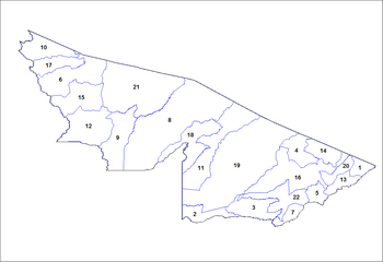
This is a list of the municipalities in the state of Acre (AC), located in the North Region of Brazil. Acre is divided into 22 municipalities, which are grouped into 5 immediate regions, which are grouped into 2 intermediate regions. [1]

South America is a continent entirely in the Western Hemisphere and mostly in the Southern Hemisphere, with a relatively small portion in the Northern Hemisphere at the northern tip of the continent. It can also be described as the southern subregion of a single continent called America.

The municipalities of Brazil are administrative divisions of the Brazilian states. Brazil currently has 5,570 municipalities, which, given the 2019 population estimate of 210,147,125, makes an average municipality population of 37,728 inhabitants. The average state in Brazil has 214 municipalities. Roraima is the least subdivided state, with 15 municipalities, while Minas Gerais is the most subdivided state, with 853.
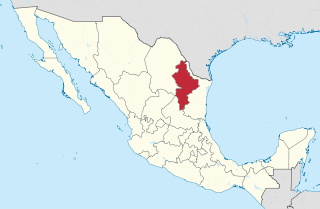
Nuevo León is a state in the northeast region of Mexico. The state was named after the New Kingdom of León, an administrative territory from the Viceroyalty of New Spain, itself was named after the historic Spanish Kingdom of León. With a total land area of 64,555 square kilometers, Nuevo León is the 13th largest federal entity in Mexico. The state is bordered by Tamaulipas to the east, Coahuila to the west, and both Zacatecas and San Luis Potosi to the south. To the north, it shares an international border with the U.S. state of Texas. The Laredo-Colombia Solidarity International Bridge is the only vehicular bridge that connects the United States with the state of Nuevo León. It crosses over the Rio Grande between the city of Colombia, Nuevo León, and Laredo, Texas.

The federative units of Brazil are subnational entities with a certain degree of autonomy and endowed with their own government and constitution, which together form the Federative Republic of Brazil. There are 26 states and one federal district. The states are generally based on historical, conventional borders which have developed over time. The states are divided into municipalities, while the Federal District assumes the competences of both a state and a municipality.
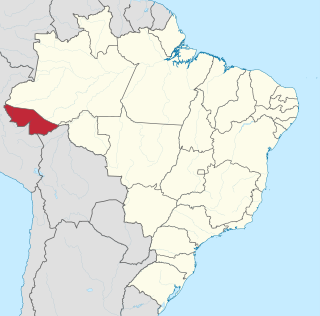
Acre is a state located in the west of the North Region of Brazil and the Amazonia Legal. Located in the westernmost part of the country, at a two-hour time difference from Brasília, Acre is bordered clockwise by the Brazilian states of Amazonas and Rondônia to the north and east, the Bolivian department of Pando to the southeast, and the Peruvian regions of Madre de Dios, Ucayali and Loreto to the south and west. The state, which has 0.42% of the Brazilian population, generates 0.2% of the Brazilian GDP.

São José do Rio Preto is a municipality in the state of São Paulo, Brazil. The city is located at the northwest portion of the state, 440 km (273 mi) from the city of São Paulo and 700 km (435 mi) from Brasília. As of the 2021 census, the population of the city was 469,173 inhabitants making it the 11th largest city in the state of São Paulo and the 36th largest city in Brazil.
The German-based varieties spoken by German Brazilians together form a significant minority language in Brazil. "Brazilian German" is strongly influenced by Portuguese and to a lesser extent by Italian dialects as well as indigenous languages. German dialects and Germanic languages are particularly strong in Brazil's South and Southeast Regions. According to Ethnologue, ca. 3 million people in Brazil speak the Hunsrik Language, 1.5 million speak Standard German.
Surčin is a municipality of the city of Belgrade. As of 2011 census, it has a population of 43,819 inhabitants.
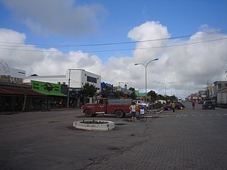
Chuí is a municipality located in the state of Rio Grande do Sul, Brazil. It's the southernmost municipality of Brazil, located in the coordinates 33°41′0″S. A border town, it shares its name with sister city Chuy, Uruguay. The two towns constitute one contiguous urban area, divided by a border street called Avenida Internacional, a situation also seen in a few other Brazilian border points, such as between Santana do Livramento (Brazil) and Rivera (Uruguay).

Time in Brazil is calculated using standard time, and the country is divided into four standard time zones: UTC−02:00, UTC−03:00, UTC−04:00 and UTC−05:00.
Brazil is divided into several types and levels of subdivisions.
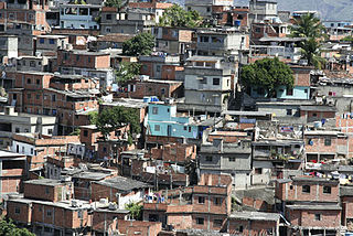
Brazil ranks 49.3 in the Gini coefficient index, with the richest 10% of Brazilians earning 43% of the nation's income, the poorest 34% earn less than 1.2%.
Magalhães Barata is a municipality in the state of Pará in the Northern region of Brazil.
The Immediate Geographic Region of Teófilo Otoni is one of the 7 immediate geographic regions in the Intermediate Geographic Region of Teófilo Otoni, one of the 70 immediate geographic regions in the Brazilian state of Minas Gerais and one of the 509 of Brazil, created by the National Institute of Geography and Statistics (IBGE) in 2017.
