
North Rhine-Westphalia or North-Rhine/Westphalia, commonly shortened to NRW, is a state (Land) in Western Germany. With more than 18 million inhabitants, it is the most populous state in Germany. Apart from the city-states, it is also the most densely populated state in Germany. Covering an area of 34,084 km2 (13,160 sq mi), it is the fourth-largest German state by size.

Pollock Pines is a census-designated place (CDP) in El Dorado County, California, United States. It is part of the Sacramento–Arden-Arcade–Roseville Metropolitan Statistical Area. Pollock Pines lies at an elevation of 3,980 feet (1,210 m) in the Sierra Nevada. The population was 7,112 at the 2020 census, up from 6,871 at the 2010 census.

Rossmoor is an unincorporated community and census-designated place (CDP) in Monroe Township, Middlesex County, New Jersey, United States. As of the 2020 census, the CDP's population was 2,992, up from 2,666 in 2010.

Cimarron is a village in Colfax County, New Mexico, United States, which sits on the eastern slopes of the Sangre de Cristo Mountains. The population was 792 at the 2020 census, making it the fourth most populous municipality in Colfax County.
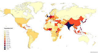
Population density is a measurement of population per unit land area. It is mostly applied to humans, but sometimes to other living organisms too. It is a key geographical term.

Urban sprawl is defined as "the spreading of urban developments on undeveloped land near a more or less densely populated city". Urban sprawl has been described as the unrestricted growth in many urban areas of housing, commercial development, and roads over large expanses of land, with little concern for very dense urban planning. Sometimes the urban areas described as the most "sprawling" are the most densely populated. In addition to describing a special form of urbanization, the term also relates to the social and environmental consequences associated with this development. In modern times some suburban areas described as "sprawl" have less detached housing and higher density than the nearby core city. Medieval suburbs suffered from the loss of protection of city walls, before the advent of industrial warfare. Modern disadvantages and costs include increased travel time, transport costs, pollution, and destruction of the countryside. The revenue for building and maintaining urban infrastructure in these areas are gained mostly through property and sales taxes. Most jobs in the US are now located in suburbs generating much of the revenue, although a lack of growth will require higher tax rates.

Saonnet is a commune in the Calvados department in the Normandy region in northwestern France.

The Regional District of Nanaimo is a regional district located on the eastern coast of Vancouver Island, British Columbia, Canada. It is bordered to the south by the Cowichan Valley Regional District, to the west by the Alberni-Clayoquot Regional District, and to the northwest by the Comox Valley Regional District. Its administration offices are located in Nanaimo. During the 2016 census, its population was established at 155,698.

The Upper Sioux Indian Reservation, or Pezihutazizi in Dakota, is the reservation of the Upper Sioux Community, a federally recognized tribe of the Dakota people, that includes the Mdewakanton.
Alberta Beach is a village in central Alberta, Canada, west of Edmonton. It is located on the southeast shore of Lac Ste. Anne, approximately 8 km (5.0 mi) west of Highway 43 and 2 km (1.2 mi) north of Highway 633.
Derwent is a hamlet in central Alberta, Canada within the County of Two Hills No. 21. It is located on Highway 45, approximately 41 kilometres (25 mi) north of Vermilion.
Minburn is a hamlet in central, Alberta, Canada within the County of Minburn No. 27. It is located on the Yellowhead Highway and the Canadian National Railway, approximately 37 km (23 mi) west of the Town of Vermilion and 143 km (89 mi) east of the City of Edmonton.
Keoma is a hamlet in southern Alberta under the jurisdiction of Rocky View County.

The Red River Delta or Hong River Delta is the flat low-lying plain formed by the Red River and its distributaries merging with the Thái Bình River in Northern Vietnam. Hồng (紅) is a Sino-Vietnamese word for "red" or "crimson". The delta has the smallest area but highest population and population density of all regions. The region, measuring some 15,000 square kilometres (6,000 sq mi) is well protected by a network of dikes. It is an agriculturally rich and densely populated area. Most of the land is devoted to rice cultivation.

Lundbreck is a hamlet in southern Alberta, Canada within the Municipal District of Pincher Creek No. 9. It is located on the south side of Highway 3, approximately 3 kilometres (1.9 mi) east of the southern terminus of Highway 22, 16 km (9.9 mi) east of the Municipality of Crowsnest Pass, 4 km (2.5 mi) west of the Village of Cowley and 16 km (9.9 mi) west of the Town of Pincher Creek. It has an elevation of 1,200 m (3,900 ft).

Antler Lake is a hamlet in Alberta, Canada within Strathcona County. It is located on the shores of Antler Lake on Range Road 211 and 211A just north of Wye Road, approximately 18 km (11 mi) east of Sherwood Park and 25 km (16 mi) northwest of Tofield.
Dr. Bhimrao Ambedkar Airstrip is an airstrip-aerodrome, situated at Partapur, 9 km south of Village Gagol of Meerut, in Uttar Pradesh, India. The airstrip, spread across 47 acres, has only non scheduled chartered flights. The government of Uttar Pradesh signed a MoU with the Airports Authority of India (AAI) in February 2014 for the development of the airport. It is named after B. R. Ambedkar.
This is a list of countries and territories in Europe by population density. Data are from the United Nations unless otherwise specified.