List of populated places in Imphal East district

Last updated

The Imphal East district of Manipur state in India is divided into 3 subdivisions. [1] At the time of the 2011 Census of India, the Jiribam district (split in 2016) was a part of the Imphal East district. [2] [3]

Contents

Subdivisions

The district has 3 subdivisions: [1] [3]

NamePopulation Effective literacy rate Sex ratio SC population % ST population %Census code (2011)
Sawombung 8616278.52%10070.27%4.49%01884
Porompat 24408987.48%10370.13%7.08%01885
Keirao Bitra 8202472.1%10119.59%1.24%01886

Towns

The district has following towns: [1] [3]

NameTypeBlockPopulationEffective literacy rateSex ratioSC population %ST population %Census code (2011)
Lamlai Nagar Panchayat Sawombung460183.98%9610.0%0.0%801494
Imphal (minor part) Municipal Council + Out growth Porompat8170588.67%10620.24%15.8%801487
Porompat Census Town Porompat619188.81%10810.1%0.27%270312
Torban (Khetri Leikai) / Kshetri Leikai Census Town Porompat545991.32%10760.05%0.2%270313
Khongman Census Town Porompat609691.76%10920.0%0.0%270314
Luwangsangbam Census Town Porompat345890.46%10630.12%11.34%270315
Heingang Census Town Porompat611584.93%10100.0%0.0%270316
Lairikyengbam Leikai Census Town Porompat458691.22%10960.0%0.13%270317
Laipham Siphai Census Town Porompat526893.07%10340.0%39.83%270318
Khurai Sajor Leikai Census Town Porompat798791.08%10790.0%0.14%270319
Chingangbam Leikai Census Town Porompat490488.89%10620.0%0.0%270320
Kshetrigao Census Town Porompat1053478.24%10710.0%0.0%270321
Thongju Census Town Porompat1083689.04%10570.0%0.0%270322
Kiyamgei Census Town Porompat533682.84%10300.0%0.0%270323
Lilong (Thoubal) Nagar Panchayat Keirao Bitra201288.79%10060.0%0.0%801476
Andro Nagar Panchayat Keirao Bitra874464.42%103087.28%0.62%801495

Villages

The district has following villages: [1] [3]

Sawombung subdivision

NamePopulationEffective literacy rateSex ratioSC population %ST population %Census code (2011)
Khongjil Khongjal 16172.06%9400.0%0.0%270204
Matakhong 53055.06%9560.0%0.0%270205
Makeng Chonglou 52073.11%11140.0%1.73%270206
Makeng Nunglou 40068.01%9320.0%0.0%270207
Makeng 28162.55%10369.61%0.0%270208
Thangal Surung 66358.54%9220.0%8.6%270209
Nurathel 10285.42%9250.0%100.0%270210
Sadu Koireng 45646.95%9910.0%2.85%270211
Purum Khunou 18256.38%11410.0%0.0%270212
Sadu Longa Koireng 33162.77%10560.0%29.91%270213
Purum Likli (Leitanpokpi)102569.79%105015.12%0.1%270214
Pukhao Naharup 147969.76%9770.0%0.07%270215
Pukhao Ahallup 46382.29%9290.0%0.0%270216
Pukhao Khabam 59381.27%9570.0%0.0%270217
Pukhao Laipham 61884.42%9740.0%0.0%270218
Sagolmang 96783.37%7520.0%1.34%270219
Khewa Company 66671.28%10240.0%0.0%270220
Yumnam Patlou 83981.4%8850.0%0.0%270221
Uyumpok 289976.14%9730.0%0.24%270222
Khongbal Tangkhul 41588.95%9860.0%94.22%270223
Lamboikhul 63482.55%10580.0%0.0%270224
Taretkhul 51142.44%10860.0%0.2%270225
Keibi Khullen 133185.5%10321.58%0.0%270226
Keibi Kumuda 186786.42%10270.0%7.18%270227
Keibi Leishangkhong 63081.17%9750.0%0.0%270228
Keibi Heikak Mapal 85966.99%8510.0%5.59%270229
Sinam 101574.18%9790.0%25.62%270230
Yumnam Khunou 187083.88%10220.0%0.05%270231
Waiton 270479.3%10060.0%0.0%270232
Sambei 65180.46%10150.0%0.0%270233
Chingkhu 64282.11%9630.0%0.0%270234
Khundrakpam 468986.56%11150.15%1.96%270235
Tangkham 123589.42%10110.0%0.0%270236
Haraorou 120789.0%10220.0%0.0%270237
Ngairangbam 30553.68%11630.0%0.0%270238
Morok Ingkhol 12350.94%7320.0%0.0%270239
Sarouthel 13272.07%9700.0%0.0%270240
Taorem 7284.13%8460.0%0.0%270241
Pangei 211288.41%9680.0%0.0%270242
Thangjam Khunou 73768.72%10360.0%0.0%270243
Sekta 293477.39%10070.24%0.17%270244
Pungdongbam 253984.83%10590.0%0.0%270245
Itam 118683.19%9670.0%24.11%270246
Iyampal 221281.87%10810.0%20.52%270247
Kangla Siphai 85982.41%10120.0%0.0%270248
Pourabi 159684.01%10150.56%0.0%270249
Nungoi 245283.9%10070.0%4.98%270250
Khabeisoi 358950.55%10310.0%1.25%270251
Angom Lawai 116890.0%10240.0%0.0%270252
Sangomsang 170191.06%10270.0%14.87%270253
Phaknung 130587.21%10300.0%0.0%270254
Chonthaba 104188.32%9790.0%0.0%270255
Sajeb 204988.42%10250.0%0.1%270256
Sanjenbam 89687.6%10180.0%0.0%270257
Sangsabi 117876.45%9700.0%0.0%270258
Salakhul 4185.37%10500.0%0.0%270259
Takhel 135876.57%9970.0%0.0%270260
Kharasom 153767.15%9580.0%0.0%270261
Kangba Chingjil 66887.65%10370.0%0.0%270262
Kameng 167378.68%10890.0%0.0%270263
Tellou 332884.12%9810.0%12.89%270264
Laikot 376577.24%10170.11%6.0%270265
Nongren 175974.82%10500.0%0.0%270266
Kakching 74286.23%10380.0%0.0%270267
Nongdam 85070.44%10240.0%0.12%270268
Oksu 87166.57%9400.0%0.34%270269
Heirok 134844.51%9910.0%60.46%270270

Porompat subdivision

NamePopulationEffective literacy rateSex ratioSC population %ST population %Census code (2011)
Kabo Siphai 166885.98%9980.0%2.64%270271
Nilakuthi 135788.67%9410.0%1.18%270272
Koirengei 144895.78%3026.98%3.94%270273
Maibakhul 68782.83%10820.0%0.0%270274
Mongjam 66586.03%10720.0%0.0%270275
Achanbigei 312385.44%10020.0%1.31%270276
Matai 114080.56%10040.0%0.0%270278
Kontha Khabam 348387.38%9900.0%0.14%270279
Kairang Meitei 125091.67%10390.0%0.0%270280
Khomidok 411665.59%10130.0%0.0%270281
Khurai Konsam Leikai 416289.6%10680.0%0.0%270282
Kairang Muslim 359365.76%10040.0%0.0%270283
Kontha Ahallup 218388.7%10710.0%0.0%270284
Lamlongei 410089.81%6250.0%20.32%270285
Thangjam Leikai 129192.98%10110.0%0.0%270286
Laishram Leikai 185189.03%10270.0%0.0%270287
Moirang Kampu 133390.77%10730.0%0.0%270288
Top Dusara (West) 194290.5%10970.0%0.05%270289
Top Dusara (East) 259782.14%10100.0%0.0%270290
Ningthoubung 203887.31%10100.0%0.0%270292
Kongkham Leikai (part)176291.4%10750.23%0.06%270293
Khaidem Leikai 272489.1%10330.0%0.0%270294
Khurai Khongnangkhong 202891.86%10820.0%0.0%270295
Kshetri Bengoon 384376.4%10140.0%0.0%270296
Wakha 59550.93%9380.0%0.0%270297
Makhapat 89189.85%8520.0%0.0%270298
Naharup 196285.59%10400.0%0.0%270299
Top Naoria 438589.95%10330.0%0.0%270300
Kongba Nongthombam Leikai 216789.72%11000.0%0.05%270301
Gangapat 147692.26%10880.0%0.0%270302
Keikhu Hao 58875.51%11000.0%99.32%270303
Thangbrijao 145477.29%10480.0%0.0%270304
Uchkeckon 375190.64%10680.0%0.03%270305
Nandeibam Leikai 337590.92%10430.0%0.0%270306
Wangkhei Loumanbi 206788.9%9860.0%0.05%270307
Kitna Panung 254687.06%10400.0%0.08%270308
Basihkhong 304291.41%10950.0%0.0%270309
Loumanbi 16186.92%10910.0%0.0%270310
Lilong Hao 73890.87%9680.0%0.0%270311

The following villages with 0 population were included in the 2011 census directory, but is no longer listed on the district website: [1] [3]

Keirao Bitra subdivision

NamePopulationEffective literacy rateSex ratioSC population %ST population %Census code (2011)
Uchekon Khunou 157391.29%10720.0%0.0%270326
Takhok Awang 128886.33%10320.0%0.0%270327
Takhok Makha 60175.05%9390.0%0.0%270328
Bamon Kampu 278888.04%10220.0%0.0%270329
Machahal 46379.31%10400.0%0.0%270330
Kalika 28485.71%8320.0%0.0%270331
Keirao Makting 531962.61%10050.0%0.0%270333
Urup 499069.04%10050.0%0.0%270334
Arapti 149572.74%10760.0%0.0%270335
Kiyamgei Muslim 261476.35%10310.0%0.0%270336
Keirao-Bitra 247083.02%10460.0%2.51%270337
Keirao-Langdum 227581.38%10740.0%0.04%270338
Langthrei Loukon 15378.99%10130.0%31.37%270339
Khanarok 57076.51%10500.0%0.0%270340
Keirao-Wangkhem 107182.79%9870.0%0.93%270341
Thiyam-Konjil 207775.3%9860.0%0.0%270342
Chanam Sandrok 159777.71%9570.0%0.25%270343
Waithou Chiru 55461.57%9300.0%99.64%270344
Huikap 338373.29%9810.0%0.21%270345
Karpur Shungba 14485.5%10570.0%100.0%270346
Angtha 291376.76%9580.0%0.0%270347
Lemba Khul 2285.0%6920.0%0.0%270348
Tulihal 559464.24%10260.0%0.0%270349
Kaina 15474.81%13330.0%0.0%270350
Poiroukhongjil 308979.64%10280.0%0.03%270351
Top-Chingtha 498570.77%10310.0%0.02%270352
Yambem 570570.1%9720.0%0.0%270353
Nungkot 11578.79%11300.0%100.0%270354
Kamu Yaithibi 7074.58%133394.29%0.0%270355
Andro (part)101448.09%100416.86%0.59%270356
Changamdabi 641966.27%10080.0%0.0%270357
Moirang Purel 257270.78%9820.0%0.08%270358
Itham 76947.83%9820.0%0.0%270359
Monthou 30658.17%9120.0%0.0%270360
Nung Brung 183278.88%10330.0%0.71%270361

The following village with 0 population was included in the 2011 census directory, but is no longer listed on the district website: Leitambi (census code 270332). [1] [3]

Related Research Articles

<span class="mw-page-title-main">Imphal</span> Capital city of the Indian state Manipur

Imphal is the capital city of the Indian state of Manipur. The metropolitan centre of the city contains the ruins of Kangla Palace, the royal seat of the former Kingdom of Manipur, surrounded by a moat. Spread over parts of the districts of Imphal West and Imphal East, the former contains the majority of the city's area and population. Imphal is part of the Smart Cities Mission under the Ministry of Housing and Urban Affairs.

<span class="mw-page-title-main">Churachandpur district</span> District in Manipur, India

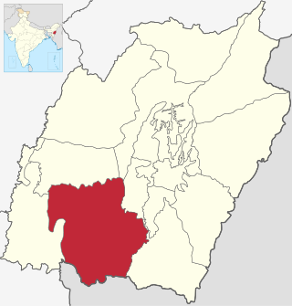
Churachandpur District, is one of the 16 districts in the southwestern corner of the Indian state of Manipur that covers an area of 4,750 kilometres (2,950 mi). It is named after the Meitei King Churachand Singh, the Maharaja of Manipur Kingdom. Churachandpur district which was previously known as Manipur South District came into existence in the year 1969 along with the district reorganization of Manipur. It stretches between 93° 15’E and 94° 45΄E Longitude and between 24°N and 24° 30 N Latitudes.

<span class="mw-page-title-main">Imphal East district</span> District of Manipur in India

Imphal East district is one of the 16 districts of Manipur state in northeastern India. As of 2011, it is the second most populous district in the state, after Imphal West.

Tamenglong district is one of the 16 districts of Manipur state in northeastern India.

Thoubal district is one of the sixteen districts of Manipur state in northeastern India. This district is bounded by Senapati district on the north, Ukhrul and Chandel districts on the east, Churchandpur and Bishnupur districts on the south and Imphal West and Imphal East districts on the west. The district occupies an area of 324 km2. The population as of 2011 is 286,687. Thoubal town is the district headquarters. This district is known for Khongjom, where the last battle of the independence of Manipur was fought in April 1891 against the British army.

<span class="mw-page-title-main">Ukhrul district</span> District of Manipur in India

Ukhrul district is an administrative district of the state of Manipur in India with its headquarters at Ukhrul, that is Hunphun. The district occupies the north-eastern corner of the state and it extends between latitudes of 24° 29′ and 25° 42′ N and longitudes 94° 30′ and 94° 45′ E approximately. It shares an international boundary with Myanmar (Burma) on its eastern side and is bounded by Nagaland state in the north, Senapati district and Kangpokpi district in the west and Kamjong district in the south. It has the distinction of being the highest hill station of Manipur. The terrain of the district is hilly with a varying heights of 913 m to 3114 m (MSL). Ukhrul, the district HQ., at an altitude of 2020 m (MSL) is linked with Imphal, the state capital by NH 202 which is about 84 kilometres apart. The district covers an area of 4,544 square kilometres including Kamjong district making it the second largest district of the state after Churachandpur district and has a population of almost 1,83,998 according to Census of India 2011 comprising about 6.44 per cent of the total state population. The Tangkhul Naga tribe constitute the major bulk of the population with other communities such as Thadou, Nepalese and other non-tribals constituting a small percentage of the district population. Administratively, the district which comprises around 200 villages was divided into five sub-divisions, where their boundaries were coterminous with that of the Tribal Development Blocks. There was no statutory town in the district except one census town which was formed in 2011 Census. Recently, Kamjong district was carved out from Ukhrul District as a separate district. Ukhrul District has three assembly constituencies before the bifurcation of the district which are Phungyar Assembly Constituency (43-ST), Ukhrul Assembly Constituency (44-ST) and Chingai Assembly Constituency. The district is best introduced by its rare Shirui Lily,. Also, the district has provided two of Manipur's chief ministers and the only from amongst the hill districts of Manipur, Yangmaso Shaiza the first tribal chief minister of Manipur and Rishang Keishing who is also the first MP from Outer Manipur. William Pettigrew (missionary), an educationist and a Scottish-British Christian Missionary pioneered the western system of education and introduced the Christianity faith among the Tangkhal Naga tribe. Phungyo Baptist Church, Tangrei, Ukhrul, the oldest and the first Christian church of Manipur which still stands today is a testament to his passion for missionary work.

Jiribam is a municipal council in the Jiribam district of the state of Manipur, India. It is one of the fastest-growing towns in Manipur.

<span class="mw-page-title-main">Thoubal</span> Town in Manipur, India

Thoubal is a town, a municipal council with 18 municipal wards and district Headquarters in Thoubal district in the Indian state of Manipur. The name 'Thoubal' comes from 'Athouba' meaning brave people symbolising the courageous people of the district. It is one of the larger towns of Manipur. It is idyllic and has many lakes and rivers, paddy fields, and gardens. It is also the window to South-East Asia as the Trans-Asian highway (AH1) passes through it. It is well connected with Imphal, Kakching, Moreh and Yairipok.

References

  1. 1 2 3 4 5 6 "Census Towns/ Wards/ Villages". District Administration Imphal East. Retrieved 2023-01-03.
  2. Esha Roy (2016-12-06). "Simply put: Seven new districts that set Manipur ablaze". Indian Express. Retrieved 2022-12-22.
  3. 1 2 3 4 5 6 "Primary census abstract at town, village and ward level, Manipur - District Imphal East - 2011". 2011 Census of India . Office of the Registrar General & Census Commissioner, India. Retrieved 2023-01-06.