This article is being considered for deletion in accordance with Wikipedia's deletion policy. Please share your thoughts on the matter at this article's deletion discussion page. |
The following table is a partial list of postal codes in Barbados .
| District | Parish | Postal Code |
|---|---|---|
| Hastings | Christ Church | BB15156 |
| Regency Park | BB15094 | |
| Dover Gardens | BB15028 | |
| Highway B - Shorey Village/Morgan Lewis | St. Andrew | BB25001 |
| Douglin Tenantry Road | BB25003 | |
| Savannah Road (GREENLAND) | BB25003 | |
| Savannah Road (GREENLAND TENANTRY) | BB25006 | |
| Savannah Road (SHOREY VILLAGE) | BB25007 | |
| Boscobel - Highway B2 | BB25012 | |
| Charles Duncan O'Neal Highway (Highway 1) | BB25012 | |
| Diamond Corner - Highway B | BB25012 | |
| Highway 2 Charles Duncan O'Neal Highway | BB25012 | |
| Rose Hill Tenantry | BB25012 | |
| Savannah Road | BB25012 | |
| Sedge Pond | BB25012 | |
| Douglin Tenantry Road | BB25015 | |
| Highway 2 (WALKERS) | BB25015 | |
| Highway 2 (WALKERS BAY) | BB25017 | |
| Bawdens -Walkers Road /Highway C | BB25020 | |
| Bawden (BAWDEN) | BB25023 | |
| Bawden (BAWDENS) | BB25024 | |
| Bawden (BAWDENS) | BB25025 | |
| Turners Hall - Swann /Highway C (BAWDENS) | BB25025 | |
| Bawdens -Walkers Road /Highway C | BB25026 | |
| Turners Hall - Swann /Highway C (WALKERS) | BB25026 | |
| Belleplaine Housing Area (WALKERS) | BB25029 | |
| Highway 2 Belleplaine | BB25029 | |
| Redman Road | BB25029 | |
| Ermy Bourne Highway | BB25031 | |
| Farell's Road | BB25031 | |
| Belleplaine Housing Area (WORRELL VALE) | BB25032 | |
| Alleyne School Road | BB25033 | |
| Belleplaine Housing Area (BELLEPLAINE) | BB25033 | |
| Jordan's Road | BB25033 | |
| Worrell's Road | BB25033 | |
| Belleplaine Housing Area | BB25034 | |
| Franklyn Doughlin Tenantry Road | BB25034 | |
| Jordan's Road A | BB25034 | |
| Highway 2 Belleplaine | BB25035 | |
| Highway 2 Haggatts | BB25035 | |
| Babylon Road | BB25036 | |
| Redman Road (WALKERS) | BB25036 | |
| Redman Road (WALKERS) | BB25037 | |
| St. Simons | BB25041 | |
| Turners Hall - Swann /Highway C | BB25044 | |
| Hillaby | BB25046 | |
| Mose Bottom Tenantry Road (GREGG FARM) | BB25049 | |
| Mose Bottom Tenantry Road (TURNER HALL) | BB25050 | |
| Belleplaine Housing Area | BB25051 | |
| Church Gap | BB25051 | |
| Harewood Road | BB25052 | |
| Hillaby/Highway D | BB25053 | |
| St. Simons | BB25060 | |
| King Street | BB25062 | |
| Franklyn Doughlin Tenantry Road | BB25064 | |
| Isolation Road (BELLEPLAINE) | BB25065 | |
| Jordan's Road | BB25065 | |
| Belleplaine Housing Area (BARBADOS H/EST) | BB25067 | |
| Cambridge #1 | BB25072 | |
| Belleplaine Housing Area (CORBIN VILLAGE) | BB25077 | |
| Corbins Village | BB25077 | |
| Chalky Mount | BB25078 | |
| Belleplaine Housing Area (BELLEPLAINE) | BB25079 | |
| Corbins Village | BB25081 | |
| Lakes | BB25081 | |
| Lakes #1 | BB25081 | |
| Chalky Mount #1 | BB25089 | |
| Belleplaine Housing Area (BRUCE VALLEY/HAGGATT) | BB25090 | |
| Isolation Road (BRUCE VALLEY/HAGGATT) | BB25090 | |
| St. Simons (BRUCE VALLEY/HAGGATT) | BB25090 | |
| St. Simons (BRUCE VALLEY/HAGGATT) | BB25092 | |
| Chalky Mount #1 | BB25093 | |
| Coggins Hill | BB25093 | |
| Highway 2 Belleplaine | BB25094 | |
| Highway 2 Haggatts | BB25098 | |
| Saddle Back | BB25100 | |
| Highway 2 Haggatts | BB25103 | |
| Highway 2C - Dark Hole | BB25104 | |
| Belleplaine Housing Area, Highway 2 Cane Garden, White Hill/Mount All | BB25107 | |
| Belleplaine Housing Area (WHITE HILL) | BB25113 | |
| Mount Hillaby | BB25114 | |
| Belleplaine Housing Area (WHITEHILL) | BB25115 | |
| Highway 2 Cane Garden | BB25121 | |
| Belleplaine Housing Area (CANE GARDEN) | BB25123 | |
| Belleplaine Housing Area (CANE GARDEN) | BB25124 | |
| Spa Hill | BB25127 | |
| POLO RIDGE, HOLDER'S HILL & JOHN'S PLAINS | St. James | BB23001 |
| BAMBOO RIDGE, 1ST& 2ND AVENUE HOYTE'S VILLAGE, HOLDER'S TERRACE, KING'S VILLAGE | BB23002 | |
| DURANT'S VILLAGE & ALL AVENUES | BB23010 | |
| 2ND AVENUE PRIOR PARK TERRACE, BAGATELLE TERRACE, BAGATELLE PARK | BB23006 | |
| HAYNESVILLE | BB23008 | |
| OXNARD CRESCENT ROAD | BB23014 | |
| CHERRY DRIVE, OXNARD ROAD, DAHLIA WALK, VIOLET CIRCLE, IVY WALK, APPLE WALK, | BB23019 | |
| ZINNIA WALK, WATERMAN VILLAGE | BB23019 | |
| DENNY ROAD, THORPE'S MAIN ROAD, 1ST & 2ND AVENUE THORPES, THORPE'S TERRACE | BB23007 | |
| RICKS ROAD | BB23015 | |
| HALL'S VILLAGE & 1ST AVENUE PRIOR PARK | BB23016 | |
| HUSBANDS GARDENS ( ALL AVENUES ) | BB23042 | |
| HUSBANDS TERRACE, BLUEBELL, CROTON, TRIDENT, HIBISCUS, TULIP, MARIGOLD DRIVES | BB23020 | |
| SUNFLOWER, OLIVE, CASSIA & GLADIOLA DRIVES | BB23020 | |
| HUSBAND'S HEIGHTS & WANSTEAD HEIGHTS | BB23021 | |
| HELICONIA DRIVE, WANSTEAD TERRACE | BB23035 | |
| OXNARDS HEIGHTS ROAD | BB23036 | |
| PRIOR PARK, CORAL GLADE, CLOVER CREST | BB23004 | |
| MOUNT STAND FAST | BB23018 | |
| WEST TERRACE GARDENS 1ST & 2ND AVENUES, POINSETTIA, ALAMANDA, GARDENIA & IXORIA DRIVES | BB23040 | |
| ORLANDA DRIVE, CHERFLEUR DRIVE | BB23040 | |
| AIRY HILL | St. Joseph | BB21034 |
| ALLEY ROAD | BB21032 | |
| ANDREWS | BB21047 | |
| AUBURN | BB21036 | |
| BATHSHEBA | BB21025, BB21027, BB21043, BB21054 | |
| BEACHMONT | BB21054 | |
| BISSEX | BB21016 | |
| BLACKMANS | BB20034, BB21036, BB21039, BB21047, BB21050, BB21053 | |
| BLOOMSBURY | BB22003 | |
| BONWELL | BB21039 | |
| SUGAR HILL | BB21033, BB22003 | |
| YEARWOOD ROAD | BB21033 | |
| VALARIE & UPPER COLLYMORE ROCK | St. Michael | BB14004 |
| BARCLAYS TERRACE | BB14006 | |
| PINDER'S AVENUE, CHAPEL PLACE, DALKEITH RIDGE, DALKEITH HILL & VILLAGE | BB14018 | |
| CHELSTON PARK, CHELSTON AVENUE & GARDENS, CULLODEN ROAD | BB14018 | |
| GOODING ROAD & BRATHWAITE'S GAP | BB14016 | |
| DEARS LAND | BB12023 | |
| WEST RIDGE, DEIGHTON ROAD, 1ST & 2ND AVE. DEIGHTON, PADDOCK RD., BULLEN'S AVENUE | BB14017 | |
| THE GARRISON, DOLPHIN COURT, BUSH HILL | BB14038 | |
| KING'S VILLAGE | BB14026 | |
| DAYRELL'S ROAD | BB14030 | |
| MEDFORD LAND | BB14033 | |
| BRITTON'S CROSS ROAD, MISSION GAP, SEAMAN'S VILLAGE, ARCHCOT TERRACE | BB14002 | |
| MCCLEAN'S GAP, WEIR'S GAP | BB14003 | |
| MILLYARD ROAD, CUMMINGS ROAD, BRYDEN'S AVENUE, KNIGHT'S ROAD, HILLBURY ROAD | BB14015 | |
| BECKLES ROAD (LEFT SIDE), CLARKE'S & LUKES AVENUE, CURWEN'S AVENUE | BB14023 | |
| FIELD PLACE, PIPERS AVENUE, CURWENS AVENUE, GITTENS AVENUE | BB14024 | |
| FRANCIS GODSON DRIVE, CULLODEN FARM | BB14001 | |
| BAY GARDENS, WATERMILL PLACE, CORDAY AVENUE, OLD QUARRY AVENUE, BAYVIEW | BB14019 | |
| WALCOTT'S AVENUE, GRANT'S AVE. | BB14020 | |
| EVELYN'S AVENUE, MANSION PLACE, FAIRVIEW | BB14021 | |
| PALM TREE PLACE, 1ST & 2ND AVENUE BECKLES HILL, CHELSEA ROAD, SAND BOX AVENUE | BB14022 | |
| BANYAN COURT | BB14022 | |
| REECE LAND & REECE ROAD | BB14013 | |
| GUNSITE ROAD, BONNETTS, RESERVOIR ROAD | BB14027 | |
| BONNETT'S HOUSING AREA & BRITTONS NEW ROAD | BB14028 | |
| REECE LAND # 1 & # 2 | BB14013 | |
| VILLA ROAD, BURKE'S ROAD, RADCLIFFE GARDENS, WARNER'S ROAD, LONDON ROAD | BB14014 | |
| LIVERPOOL ROAD, MANCHESTER ROAD | BB14014 | |
| UPPER & LOWER STREAT'S ROAD, UPPER & LOWER IFILL ROAD, MOUNT CLAPHAM | BB14005 | |
| FLAGSTAFF | BB14005 | |
| WILDEY MAIN ROAD TO WILDEY HEIGHTS - CHEFFETTE | BB14007 | |
| UPPER FORDE'S ROAD | BB14009 | |
| PLANTAIN WALK, CLAPHAM DRIVE, LOWER FORDE'S ROAD | BB14011 | |
| CLUB MORGAN - 1ST, 2ND, 3RD, 5TH & 6TH AVENUES | BB14029 | |
| HIGHGATE GARDENS, HIGHGATE PARK | BB14005 | |
| WILDEY INDUSTRIAL PARK | BB14006 | |
| CLAPHAM PARK, CLAPHAM HEIGHTS, OBSERVATORY ROAD, HARPERS LAND | BB14008 | |
| FRANKLIN DEVELOPMENT | BB14008 | |
| LAYNES ROAD, CLAPHAM CLOSE, GAS PRODUCTS GAP | BB14012 | |
| WANSTEAD GARDENS & DRIVE | BB23034 | |
| WANSTEAD TERRACE | BB23038 | |
| PARADISE HEIGHTS | BB23039 | |
| WARRENS SOUTH, REGENCY DRIVE | BB23028 | |
| CLERMONT GARDENS & GREENS, WEST ROAD, CLERPARK | BB23029 | |
| RESERVOIR ROAD & PIPERS AVENUE | BB23030 | |
| HUSBANDS NEW DEVELOPMENT, HUSBANDS CREST, HUSBANDS MAIN ROAD | BB23032 | |
| AIRLIE TENANTRY #1 & #2 | BB23033 | |
| WARRENS PARK | BB23027 | |
| BAGATELLE TERRACE | St. Thomas | BB23003 |
| WARREN'S HEIGHTS | BB23025 | |
| DUNSCOMBE | BB22007 | |
| FARMERS HOUSING AREA | BB22008 | |
| CONTENT | BB22009 | |
| FARM PARK | BB22012 | |
| POREY SPRING | BB22021 | |
| SPRING FARM | BB22023 | |
| FARM DEVELOPMENT | BB22024 | |
| FORTRESS HILL | BB22047 | |
| ROCK HALL | BB22008 | |
| CONTENT | BB22009 | |
| ARCH HALL | BB22017 | |
| ARTHUR SEAT | BB22022 | |
| WARREN'S COMMERCIAL AREA (INDUSTRIAL PARK) | BB22026 | |
| KEW LAND, BAGATELLE H/A | BB22018 | |
| WELCHES, GIBSON LAND, REDMANS VILLAGE | BB22025 | |
| SHOP HILL - VACLUSE FACTORY | BB22016 | |
| GRAN VIEW - OLD SHARON & CHRISTIE VILLAGE | BB22017 | |
| EDGE HILL TERRACE - PHASE 1 & 2 | BB22020 | |
| GRAN VIEW HGT- SHOP HILL TER | BB22024 | |
| LESTER VAUGHN SCHOOL | BB22030 | |
| ASHFORD | BB22058 | |
| HOLY INNOCENTS | BB22065 | |
| HOPEWELL TERRACE | BB22078 | |
| LES CHAMPS | BB22088 | |
| CANE GARDEN PLTN | BB22103 | |
| FORTY ACRES, RUBY, GLENDALE | BB22108 | |
| BRIDGEFIELD | BB22115 | |
| CANE GARDEN TERRACE & PARK | BB22129 | |
| STURGES | BB22022 | |
| CARRINGTON VILLAGE | BB22029 | |
| BLOOMSBURG | BB22031 | |
| VAULT ROAD | BB22041 | |
| UPPER WELCHMAN HALL MAIN ROAD | BB22047 | |
| ALLEN VIEW | BB22051 | |
| BRYAN RD | BB22057 | |
| LOWER WELCHMAN HALL MAIN ROAD | BB22058 | |
| BLUNTS + AIRY COTT | BB22002 | |
| VAULT RD, HIGHLAND, WELCHMAN HALL 1- 2 AVE | BB22005 | |
| LION CASTLE, LEWIS VILLAGE, DUKE'S, LOWER & UPPER CANEFIELD | BB22006 | |
| CLIFTON HILL | BB22060 | |
| MOUNT WILTON | BB22069 | |
| WALKES SPRING | BB22070 | |
| BLOOMSBURY | BB22072 | |
| CLIFTON TENT | BB22073 | |
| PROUTE HILL, CHURCH GAP | BB22079 | |
| STRONG HOPE | BB22087 | |
| PROUTE HILL | BB22091 | |
| EXCHANGE | BB22111 | |
| APPLEWHAITE | BB22146 | |
| CANE HILL | BB22090 | |
| CANE GARDEN HEIGHTS | BB22096 | |
| WHITEHALL ROAD | BB22101 | |
| REECE ROAD | BB22112 | |
| EDGE HILL ROAD | BB22118 | |
| CANE GARDEN | BB22135 | |
| SHARON | BB22136 | |
| WARRENS CRESCENT | BB23026 | |
| Featherbed Lane | St. John | BB20026 |
| VICTORIA | BB20025 | |
| GEMSWICK | St. Philip | BB18098 |

Barbados is an island country in the Lesser Antilles of the West Indies, in the Caribbean region of the Americas, and the most easterly of the Caribbean Islands. It is 34 kilometres in length and up to 23 km (14 mi) in width, covering an area of 432 km2 (167 sq mi). It is in the western part of the North Atlantic, 100 km (62 mi) east of the Windward Islands and the Caribbean Sea. Barbados is located roughly 13°N of the equator. It is about 168 km (104 mi) east of both the countries of Saint Lucia and Saint Vincent and the Grenadines and 180 km (110 mi) south-east of Martinique and 400 km (250 mi) north-east of Trinidad and Tobago. Barbados is outside the principal Atlantic hurricane belt. Its capital and largest city is Bridgetown.

The United States Postal Service is an independent agency of the executive branch of the United States federal government responsible for providing postal service in the United States, including its insular areas and associated states. It is one of the few government agencies explicitly authorized by the United States Constitution. The USPS, as of 2021, has 516,636 career employees and 136,531 non-career employees.

A postal code is a series of letters or digits or both, sometimes including spaces or punctuation, included in a postal address for the purpose of sorting mail.
Communications in Barbados refers to the telephony, internet, postal, radio, and television systems of Barbados. Barbados has long been an informational and communications centre in the Caribbean region. Electricity coverage throughout Barbados is good and reliable. Usage is high and provided by a service monopoly, Barbados Light & Power Company Ltd..
The military history of Barbados comprises hundreds of years of military activity on the island of Barbados, as well as international military and peacekeeping operations in which Barbadians took part.
This is a partial timeline of significant events in postal history, including dates and events relating to postage stamps.
BPS, Bps or bps may refer to:
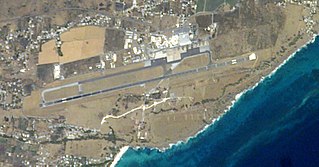
Grantley Adams International Airport (GAIA) is the international airport of Barbados, located in Seawell, Christ Church. It is the only designated port of entry for persons arriving and departing by air in Barbados and operates as one of the major gateways to the Eastern Caribbean. The airport has direct service to destinations in the United States, Canada, Central America and Europe. In 2016, the airport was the eighth-busiest airport in the Caribbean region and the third-busiest airport in the Lesser Antilles after Queen Beatrix International Airport on Aruba and Pointe-à-Pitre International Airport on Guadeloupe. GAIA, also remains an important air-link for cruise ship passengers departing and arriving at the Port of Bridgetown, and a base of operations for the Regional Security System (RSS), and the Regional (Caribbean) Police Training Centre.

The Kensington Oval is a stadium located to the west of the capital city Bridgetown on the island of Barbados. It is the pre-eminent sporting facility on the island and is primarily used for cricket. it has hosted many important and exciting cricket games between local, regional, and international teams during its more than 120-year history.
ISO 3166-2:BB is the entry for Barbados in ISO 3166-2, part of the ISO 3166 standard published by the International Organization for Standardization (ISO), which defines codes for the names of the principal subdivisions of all countries coded in ISO 3166-1.
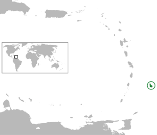
The following is an alphabetical list of topics related to the nation of Barbados.
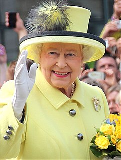
The monarchy of Barbados was a system of government in which a hereditary monarch was the sovereign and head of state of Barbados. Barbados shared the Sovereign with the other Commonwealth realms, with the country's monarchy being separate and legally distinct. The Barbadian monarch's operational and ceremonial duties were mostly delegated to her representative, the Governor-General of Barbados.

The following outline is provided as an overview of and introduction to Barbados:

Mauritius, a small island in the southwest Indian Ocean, is of towering importance in the world of philately for a number of reasons. Its first two postage stamps issued in 1847, called the "Post Office" stamps, are of legendary rarity and value. They were the first stamps issued in any part of the British Empire outside of Great Britain. The unique cover bearing both “Post Office” stamps has been called "la pièce de résistance de toute la philatélie" or "the greatest item in all philately". The cover was sold at auction, in Zurich, on 3 November 1993, for 5.75 million Swiss francs, the equivalent of about $4 million – the highest price ever paid for a single philatelic item up to that time. In addition, Mauritius is well known for the subsequent locally produced issues known as "primitives," also prized by collectors.
Postal codes in Barbados are 5 digit numeric, with ISO 3166-1 alpha-2 prefix.
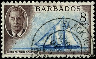
This is a survey of the postage stamps and postal history of Barbados.
The Barbados Postal Service (B.P.S.) is the national postal operator of Barbados and operates as a department within the Government of Barbados where it reports to the Ministry of Home Affairs. The Barbados Postal Service (B.P.S.) is headed by the acting Postmaster General, Sheila Greaves, who is responsible for maintaining the island’s postal services, subject to the laws of the island. In 1852, the Postal services for Barbados were reconstituted following the passage of local legislation enabling the delivery of inland postage.
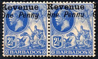
The island of Barbados first issued revenue stamps in 1916. There were various types of fiscal stamps for different taxes.