Related Research Articles

The National highways in India are a network of trunk roads owned by the Ministry of Road Transport and Highways. National highways have flyover access or some controlled-access, where entrance and exit is through the side of the flyover, at each intersection of highways flyovers are provided to bypass the city/town/village traffic and these highways are designed for speed of 100 km/h. Some national highways have interchanges in between, but do not have total controlled-access throughout the highways. It is constructed and managed by the Central Public Works Department (CPWD), the National Highways and Infrastructure Development Corporation Limited (NHIDCL), and the public works departments (PWD) of state governments. Currently, the longest National Highway in India is National Highway 44 at 4,112 km (2,555 mi). India started four laning of major national highways with National Highway Development Project (NHDP). As of March 2022 India have approximately 35,000 km of four laned National highways.
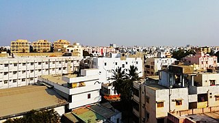
Kavali is a town in Nellore district of Andhra Pradesh of India. It also serves as headquarters of Kavali mandal and Kavali revenue division.It is one of the few cities from Andhra Pradesh which were selected for Atal Mission for Rejuvenation and Urban Transformation (AMRUT) Scheme.
E-470 is a 47-mile-long (76 km) controlled-access toll road that traverses the eastern portion of the Denver metropolitan area in the US state of Colorado. It is the eastern half of the 470 beltway that serves Meridian, Parker, Aurora, Denver International Airport, and Brighton.
The National Highways Authority of India or NHAI is an autonomous agency of the Government of India, set up in 1995 and is responsible for management of a road network of over 50,000 km of National Highways out of 1,32,499 km in India. It is a nodal agency of the Ministry of Road Transport and Highways (MoRTH). NHAI has signed a memorandum of understanding (MoU) with the Indian Space Research Organisation (ISRO) for satellite mapping of highways.

Roads in India are an important mode of transport in India. India has a network of over 6,331,791 kilometres (3,934,393 mi) of roads. This is the second-largest road network in the world, after the United States. At of roads per square kilometre of land, the quantitative density of India's road network is equal to that of Hong Kong, and substantially higher than the United States, China, Brazil and Russia. Adjusted for its large population, India has approximately 5.13 kilometres (3.19 mi) of roads per 1,000 people, which is much lower than United States 20.5 kilometres (12.7 mi) but higher than that of China 3.6 kilometres (2.2 mi). India's road network carries over 71% of its freight and about 85% of passenger traffic.

The M-9 motorway or the Karachi–Hyderabad motorway is a north–south motorway in the Sindh province of Pakistan, connecting Karachi to Hyderabad. The six-lane road is 136 kilometres long, and caters to the commercial traffic originating from the Karachi Port and Port Qasim. Daily traffic count is around 30,000.
National Highway 44 is a major north–south National Highway in India and is the longest in the country.
The city of Karachi is a major transport hub of Pakistan. The Karachi port and airport are major gateways to Pakistan. The Karachi Railway stations transports the major part of Pakistan's trade with other countries.
Expressways are the highest class of roads in India. As of July 2023, India has a total length of 5,173 km (3,214 mi) of expressways. These are controlled-access highways where entrance and exits are controlled by the use of cloverleaf or trumpet or grade separated interchanges that are incorporated into the design of the expressway and designed for maximum speed of 120 km/h, whereas National highways are flyover access or tolled, where entrance and exit is through the side of the flyover, at each intersection of highway with road, flyovers are provided to bypass the city/town/village traffic and these highways are designed for speed of 100 km/h. Some roads are not access-controlled expressways but are still named expressways, such as the Biju Expressway, these are actually state highways that are not declared by the central government as an Expressway, hence not an Expressway or National Highway.

The Islamabad Expressway, sometimes also referred to as Islamabad Highway, is a major north–south expressway in Islamabad, Capital Territory, Pakistan. The expressway provides quick access between the Islamabad and Rawalpindi, Punjab, connecting the national capital with the N-5 National Highway. It stretches from Zero Point Interchange with the Kashmir Highway in Islamabad to Rawat, Islamabad Capital Territory on the N-5 National Highway. The total length of the expressway is 28 kilometers (17 mi), with lanes varying from six to ten.

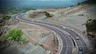
The M-15 Motorway, also known as the Hazara Motorway, is a 180-kilometer controlled-access motorway in Pakistan. It links the Burhan Interchange near Hasan Abdal in the Punjab province with Haripur, Havelian, Abbottabad, Mansehra, Shinkiari, Battagram, and Thakot in the Hazara Division of the Khyber Pakhtunkhwa province.

The National Highway 70, or the N-70, is one of the National Highways of Pakistan. It runs from the city of Multan in Punjab to the town of Qilla Saifullah via Dera Ghazi Khan, and Loralai in Balochistan province. Its total length is 440 kilometres (270 mi) divided into 254 kilometres (158 mi) in Balochistan and the remaining 186 km (116 mi) in the Punjab. It is maintained and operated by Pakistan's National Highway Authority.

Makhdoomzada Syed Basit Sultan Bukhari is a Pakistani politician who had been a member of the National Assembly of Pakistan from August 2018 till August 2023. Previously he was a member of the National Assembly from 2002 to 2007 and again from June 2013 to April 2018.
The Politics of Muzaffargarh takes place at the municipal, provincial and federal levels of the government. ؐMuzaffargarh is a multiethnic, multilingual, multicultural and multireligious city. Tthere are one Municipal Corporation, six Municipal committees, thirteen Town committee and five Thesil councils according to he Punjab Local Government Act 2019. At a national level, Muzaffargarh is very important in provincial and national politics.
Karnal Sher Khan Shaheed Road, previously known as the IJP Road, or the Inter Junction Point Road, is one of the busiest roads in the Islamabad–Rawalpindi metropolitan area in Pakistan, connecting Islamabad to Rawalpindi. It also serves as a route for traffic coming from Punjab and Azad Kashmir going towards Taxila, Attock, and onwards to Khyber Pakhtunkhwa. It is named IJ Principle Road because it is the road that was going to be between the never-built Sector J and Sector I of Islamabad.
References
- ↑ "NHA-Road-Network-Maps" (PDF). National Highway Authority (Pakistan). Archived from the original (PDF) on 20 June 2014. Retrieved 5 December 2014.
- ↑ "N-70 (Multan - Qila Saifullah)". National Highway Authority. Retrieved 5 December 2014.
- ↑ "PM Imran inaugurates Muzaffargarh-DG Khan highway". The Express Tribune. 2020-02-21. Retrieved 2022-05-30.
- ↑ "Six die in Muzaffargarh road accident". The Express Tribune. 2020-08-04. Retrieved 2022-05-27.
- ↑ "Transportation | Muzaffargarh". muzaffargarh.punjab.gov.pk. Retrieved 2022-05-27.