Konstantinos Kanaris, also anglicised as Constantine Kanaris or Canaris, was a Greek admiral, Prime Minister, and a hero of the Greek War of Independence.

Fiordland is a geographical region of New Zealand in the south-western corner of the South Island, comprising the westernmost third of Southland. Most of Fiordland is dominated by the steep sides of the snow-capped Southern Alps, deep lakes, and its steep, glacier-carved and now ocean-flooded western valleys. The name "Fiordland" comes from a variant spelling of the Scandinavian word for this type of steep valley, "fjord". The area of Fiordland is dominated by, and very roughly coterminous with, Fiordland National Park, New Zealand's largest National Park.

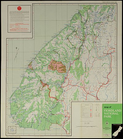
Fiordland National Park occupies the southwest corner of the South Island of New Zealand. It is by far the largest of the 13 national parks in New Zealand, with an area of 12,607 square kilometres (4,868 sq mi), and a major part of the Te Wahipounamu World Heritage Site. The park is administered by the Department of Conservation.

Doubtful Sound / Patea is a fiord in Fiordland, in the far south west of New Zealand. It is located in the same region as the smaller but more famous and accessible Milford Sound / Piopiotahi. It took second place after Milford Sound as New Zealand's most famous tourism destination.

Lake Manapouri is located in the South Island of New Zealand. The lake is situated within the Fiordland National Park and the wider region of Te Wahipounamu South West New Zealand World Heritage Area.

Manapouri is a small town in Southland / Fiordland, in the southwest corner of the South Island, in New Zealand. The township is the westernmost municipality in New Zealand. Located at the edge of the Fiordland National Park, on the eastern shore of Lake Manapouri, close to its outflow into the Waiau River, tourist boat services are based in the town.

Tamatea / Dusky Sound is a fiord on the southwest corner of New Zealand, in Fiordland National Park.

Pelorus Sound is the largest of the sounds which make up the Marlborough Sounds at the north of the South Island, New Zealand.

Rakituma / Preservation Inlet is the southernmost fiord in Fiordland National Park and lies on the southwest corner of the South Island of New Zealand. With an area of 93 square kilometres (36 sq mi), it is the fourth largest fiord in New Zealand, after Tamatea / Dusky Sound, Doubtful Sound / Patea, and the neighbouring Taiari / Chalky Inlet to the north. Rakituma was briefly the site of an attempted fishing and gold mining settlement at Cromarty during the 19th century, however this was quickly abandoned once the level of gold declined in relation to more promising fields elsewhere.

Deep Cove is an arm of Doubtful Sound, a deep indentation in the southwest coast of New Zealand's South Island. Along with the Hall Arm, which lies to the southwest of Deep Cove, it forms one of the two most remote parts of the sound from the Tasman Sea, with its mouth being 32 kilometres (20 mi) from the mouth of Doubtful Sound. Elizabeth Island lies close to the junction of Deep Cove and the Hall Arm. Deep Cove by itself is about four kilometres long and is home to several waterfalls, including Helena Falls and Lady Alice Falls.
The Wilmot Pass is a 671 m (2,201 ft) high pass on the main divide of New Zealand's South Island. It connects Doubtful Sound, a deep indentation in the coast of Fiordland, to the valley of the West Arm of Lake Manapouri. The pass is named after E. H. Wilmot, a former surveyor-general of New Zealand, who had noted it while surveying the area in 1897. It lies between Mount Wilmot and Mount Mainwaring. On the east side the Spey River drains to Lake Manapouri and on the west side the Lyvia River drains to Deep Cove.
The Carrick River is a river of Fiordland, close to the southwesternmost point of New Zealand's South Island. Its course is predominantly southward, and passes through numerous small lakes, most notably Lake Victor, before reaching the sea at the Islet Cove of Te Korowhakaunu / Kanáris Sound.

Kaikiekie / Bradshaw Sound is one of the larger New Zealand fiords. It is one of the sub fiords/arms that make up the Doubtful Sound/Thompson Sound complex and forms the northernmost of the blind or dead end fiords in this system.
Taiporoporo / Charles Sound is a fiord of the South Island of New Zealand. It is one of the fiords that form the coast of Fiordland.
Hinenui / Nancy Sound is a fiord on the South Island of New Zealand. It is one of the fiords that form the coast of Fiordland.
Taiari / Chalky Inlet is one of the southernmost fiords in Fiordland, in the southwestern corner of New Zealand's South Island and part of Fiordland National Park. As with the neighbouring fiords of Tamatea / Dusky Sound to the north and Rakituma / Preservation Inlet to the south, Taiari / Chalky Inlet is a complex fiord with many channels and islands along its roughly 28 km (17 mi) length. Most notably, this includes the sections Moana-whenua-pōuri / Edwardson Sound and Te Korowhakaunu / Kanáris Sound, which split at Divide Head in the middle of Taiari and each extend for roughly 10 km (6.2 mi) inland in a V-shape.
Endeavour Inlet is a large inlet of Queen Charlotte Sound, part of New Zealand's Marlborough Sounds. It lies north-east of Bay of Many Coves / Miritū Bay and south-west of Resolution Bay. The inlet is home to a number of retreats, including Furneaux Lodge and Punga Cove.