
The 2004 Pacific typhoon season was an extremely active season that featured the second-highest ACE ever recorded in a single season, second only to 1997, which featured 29 named storms, nineteen typhoons, and six super typhoons. It was an event in the annual cycle of tropical cyclone formation, in which tropical cyclones form in the western Pacific Ocean. The season ran throughout 2004, though most tropical cyclones typically develop between May and October. The season's first named storm and also the first typhoon, Sudal, developed on April 4, later was reached typhoon status two days later, and became the first super typhoon of the year three days later. The season's last named storm, Noru, dissipated on December 21.

The 1990 Pacific typhoon season was another active season. It has no official bounds; it ran year-round in 1990, but most tropical cyclones tend to form in the northwestern Pacific Ocean between May and November. These dates conventionally delimit the period of each year when most tropical cyclones form in the northwestern Pacific Ocean.

The 1977 Pacific typhoon season was one of the least active Pacific typhoon seasons on record, with only 19 tropical storms forming. It was also the second of three known typhoon seasons during the satellite era to not produce a Category 5-equivalent super typhoon, sandwiched between the 1974 and 2017 seasons. The season's first storm, Severe Tropical Storm Patsy, formed on March 23 and the last, Typhoon Mary, dissipated on January 2, 1978. With Mary spanning two calendar years, it became the fourth typhoon to do so since 1945. Since then, two other typhoons have achieved this feat.

The 1976 Pacific typhoon season has no official bounds; it ran year-round in 1976, but most tropical cyclones tend to form in the northwestern Pacific Ocean between June and December. These dates conventionally delimit the period of each year when most tropical cyclones form in the northwestern Pacific Ocean.

Typhoon Fengshen, known in the Philippines as Typhoon Frank, was the sixth named storm and the fourth typhoon recognized by the Japan Meteorological Agency. The Joint Typhoon Warning Center recognized Fengshen as the seventh tropical depression, the sixth tropical storm, and fifth typhoon of the 2008 Pacific typhoon season.

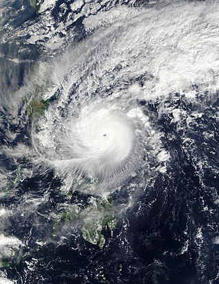
Typhoon Angela, known in the Philippines as Super Typhoon Rosing, was an extremely powerful and catastrophic tropical cyclone that impacted the Philippines in November 1995, and the most intense tropical cyclone worldwide in 1995. Typhoon Angela was the third storm in a row that struck the Philippines, following Yvette and Zack. Typhoon Angela was the twenty-ninth tropical cyclone, and the fifth super typhoon of the moderately active 1995 Pacific typhoon season.

Severe Tropical Storm Nock-ten, known in the Philippines as Severe Tropical Storm Juaning, was a strong tropical storm which made a total of four landfalls in Southeast Asia, killing more than 100 people and causing damage estimated at US$126 million. It was the eighth named storm and the fourth severe tropical storm of the 2011 Pacific typhoon season.

Severe Tropical Storm Koni, known in the Philippines as Tropical Storm Gilas, caused moderate damage to areas of China and Vietnam in July 2003. The eighth tropical storm in the western Pacific that year, Koni originated from a disturbance situated within the monsoon trough well east of the Philippines on July 15. Tracking westward, intensification was slow and the system remained a tropical depression as it moved across the central Philippines on July 17. Upon moving into the South China Sea, however, conditions allowed for quicker strengthening, and as such the cyclone reached tropical storm status on July 18 before reaching its peak intensity with maximum sustained winds of 110 km/h (68 mph) and a minimum barometric pressure of 975 mbar, making it a severe tropical storm. However, atmospheric conditions began to deteriorate as Koni made landfall on Hainan on July 21, weakening the system. The tropical storm continued to weaken as it moved over the Gulf of Tonkin prior to a final landfall near Hanoi, Vietnam the following day. Tracking inland, the combination of land interaction and wind shear caused Koni to dissipate over Laos on July 23.
Typhoon Nock-ten, known in the Philippines as Super Typhoon Nina, was the strongest Christmas Day tropical cyclone worldwide in terms of 1-minute sustained winds. Forming as a tropical depression southeast of Yap and strengthening into the twenty-sixth tropical storm of the annual typhoon season on December 21, 2016, Nock-ten intensified into the thirteenth typhoon of the season on December 23. Soon afterwards, the system underwent explosive intensification and became a Category 5-equivalent super typhoon early on December 25. Nock-ten weakened shortly afterwards before making eight landfalls over the Philippines. The typhoon weakened rapidly due to the landfalls as it entered the South China Sea on December 26, turned southwest, and ultimately dissipated on December 28 due to the winter monsoon.

Typhoon Phanfone, known in the Philippines as Typhoon Ursula, was a strong and deadly tropical cyclone which traversed the Philippines on Christmas Eve and Christmas Day in 2019, the first typhoon to do so since Nock-ten in 2016.
This page is based on this
Wikipedia article Text is available under the
CC BY-SA 4.0 license; additional terms may apply.
Images, videos and audio are available under their respective licenses.