List of tallest buildings and structures in Belfast

Last updated

Tall buildings in Belfast
Belfast skyline - geograph.org.uk - 6219085.jpg
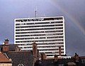
A portion of Belfast's skyline in 2019, featuring Obel Tower
Tallest building Obel Tower (2010)
Height of tallest building85 m (279 ft)
Buildings above 50 m18 (2025)

This list of the tallest buildings and structures in Belfast ranks buildings and structures in Belfast, Northern Ireland, by height. Belfast is the capital and largest city of Northern Ireland, and hosts the majority of its high-rise buildings. The tallest building in the city is Obel Tower at 86 metres (282 feet), a residential high-rise completed in 2010. It is the tallest building in both Northern Ireland and the entire island of Ireland. The tallest structure is the Black Mountain transmitting station, which rises to a height of 228.6 m (750 ft)

Contents

There are at least 10 structures in the city taller than 80 metres (260 ft) and there are at least 36 habitable buildings in the city taller than 45 metres (148 ft).

Tallest by category

Tallest structures

86m (282 ft) Obel Tower in Belfast is Ireland's tallest building. Obel Tower Belfast.png
86m (282 ft) Obel Tower in Belfast is Ireland's tallest building.
Albert Memorial Clock Albert Memorial Clock Belfast 2014 003.jpg
Albert Memorial Clock

These lists rank the 8 tallest structures in Belfast by total height.

Belfast Tallest Structures
RankNameUseImageHeight (m)Height (ft)Floors above groundYear of completionNotes
1 Black Mountain transmitting station TV mast
Divis Road near Divis - geograph.org.uk - 905212.jpg 228.6750N/A1959 [1]
=2 Divis transmitting station TV mast Divis Transmitting Station (geograph 5761963).jpg 166545N/A2011 [2]
4"Samson"Shipbuilding Gantry Crane
Harland and Wolff crane, Belfast, April 2010 (12).JPG
106348N/A1974 [3]
5Belfast Ship repair Quay craneShip repair Crane Cranes close to East Twin Road, Belfast Docks - geograph.org.uk - 1634429.jpg 104341N/Aunknown [4]
6"Goliath"Shipbuilding Gantry Crane Samson and Goliath 2018-07-27.jpg 96316N/A1969 [3]
7Belfast City Hospital ChimneyChimney Belfast rooftops - geograph.org.uk - 689168.jpg 95312N/A1986 [5]
8 Grand Central Hotel Hotel The Grand Central Hotel, Belfast (Oct 2018).jpg 93305231975 [6]

[7] [8] The building portion of the hotel is only 80 metres tall, while the structural element reaches a height of 93 metres.

9 Obel Residential Obel Tower completed.jpg 86281282010 [9]
10 St Anne's Cathedral (Church of Ireland)Church St Annes Cathedral, Belfast, July 2010 (37).JPG 80262N/A2007 [10]

Tallest buildings

This list ranks buildings in Belfast that stand at least 200 m (656 ft) tall, based on standard height measurement. This includes spires and architectural details but does not include antenna masts.

Belfast tallest Buildings
RankNameUseImageHeight (m)Height (ft)Floors
(above ground)
Year of completionNotes
1 Obel Residential Obel Tower completed.jpg 86282282010 [9]
2 Grand Central Hotel Hotel The Grand Central Hotel, Belfast (Oct 2018).jpg 80262231975 [6]

[7] [8] The building portion of the hotel is only 80 metres tall, while the structural element reaches a height of 93 metres.

3 Belfast City Hospital Tower Hospital Belfast City Hospital - geograph.org.uk - 935083.jpg 76249151986 [11]
4City Quays 3Office City Quays 3.jpg 74243162021 (topped out) [12] [13] [14]
5The EwartOffice Bedford Square Belfast.jpg 73 [a] 240172021 (topped out) [15] [16]

(Nicknamed "R2D2" for the Star Wars droid)[ citation needed ]

6 Belfast International Hilton Hotel Hotel DSCF1320.JPG 63207161998 [17]
7 BT Riverside Tower Office BT Riverside Tower, Belfast, April 2010 (02).JPG 62203141998 [18]
8 Divis Tower Residential Divis Tower, Belfast, May 2011 (01).JPG 61200201966 [19]
9=The BoatOffice/Residential The Boat 09.08.10.JPG 57187152010 [20] [b]
9= Royal Victoria Hospital Critical Care Building Hospital Royal Hospital Belfast 02.jpg 57187122012 [21] [22] [c]
11=Linum Chambers Bedford SquareOffice Bedford Square 18.08.12 029.jpg 55180132005 [23]
11=Causeway TowerOffice Causeway Tower 13.09.12.jpg 55180132004 [24]
11=Great Northern TowerOffice Great Northern Mall, Great Victoria Street, Belfast - geograph.org.uk - 1593903.jpg 55180131992 [25]
14Ulster University Belfast CampusUniversity Ulster University - Belfast Campus - BD building - March 2023.jpg 52 [d] 171132021 [26]
15Grainne HouseResidential New lodge towers-thm.jpg 52171171968 [27]
16 Europa Hotel Hotel Europa Hotel 2.jpg 51167131971 [28]
17=Bruce Street Student accommodationStudent accommodation Bruce street student accommodation.jpg 51167152023 [29]
17=Lanyon PlazaOffice No 8 Lanyon Place, Belfast (14) - geograph.org.uk - 1716262.jpg 50164122014 [30]
19=Bedford HouseOffice Bedford House, Bedford Street, Belfast.jpg 49161121966 [31]
19=River HouseOffice River House, Belfast.jpg 49161141970 Building reclad in 2018. [32] [33]
19=Ferndale House

Parkdale House

Riverdale House

Residential
Multi-storey flats, Seymour Hill, Dunmurry (1) - geograph.org.uk - 1222162.jpg
49161151965 [34] [35] [36]
19=Coolemoyne House

Rathmoyne House

Residential
Kingsway, Dunmurry - geograph.org.uk - 650067.jpg
49161151962 [37] [38]
26Queen's University Medical Biology Centre

(MBC)

University Queen's University Medical Biology Centre, Belfast - geograph.org.uk - 913549.jpg 48158121969 [39]
27Swanston House 41-49 Queen streetResidential (student) Queen Street 41-49. 10.09.18.jpg 47155142016 [40]
28=14 Great Victoria StreetOffice 14-18 Great Victoria Street 13.09.12.jpg 46151112003 [41]
28=Fanum HouseOffice Fanum House August 2011.jpg 46151131965 [42]
28=Dundonald houseOffice Dundonald House - 3724956 f8d69b20.jpg 4615112early 1960s [43] [44]


28= Ashby Building University Ashby Building, Belfast (43963470780).jpg 46151111965 [45]
28=101 York StreetResidential (student) Wiki york street.jpg 46151142021 (topped out) [46]
33=Kilbroney HouseResidential Football Pitch and Kilbroney House, Cregagh - geograph.org.uk - 1392895.jpg 45148151967 [47]
33=Carnet HouseResidential Carnet House, Belfast (June 2017).jpg 45148151966 [48]
33=Bradbury courtResidential Belfast rooftops - geograph.org.uk - 689168.jpg 4514815Early 1960s [49]
33=FX, 14-18 Montgomery streetResidential Montgomery Street 14-18 11.09.20.jpg 45148152019 [50]
33=Maldron hotelHotel Maldron Hotel, 20 Brunswick Street, Belfast.jpg 45148152018 [51]
33=Elms BT2, McClintock StreetResidential (student) Elms BT2 (2) 26.02.21.jpg 45148162018 [52]
  1. Note: This building height is incorrectly listed as 62m in both planning applications and in Emporis, but that is the height of the lower roof/arm of building (easy mistake from side elevation) but ignores the last 3 floors, to the upper roof (not a plant), real height is seen in plan documents already cited.
  2. Recent applications, including the corporation street apartments and queens quay masterplan (see below with citations) have height as 57m not 62m assuming similar error with critical care building, by taking height above sea level as full height (cited in table).
  3. New children's hospital application reveals original height was only above sea level not base to roof so 63m is height above sea level
  4. Height above sea level once again being quoted as height (56m) but base to top it is 52m

Tallest non-habitable buildings

List of tallest non Habitable buildings over 45m tall in Belfast. Non-Habitable building refers to a building where most of the height is taken up by an architectural feature which is not habitable such as a spire, or storage space.

RankNameUseImageHeight (m)Height (ft)Year of ConstructionNotes
1 St Anne's Cathedral Anglican Cathedral (Church of Ireland) St Annes Cathedral, Belfast, July 2010 (37).JPG 802622007 [10]
2 St Patrick's Church, Belfast Roman Catholic chapel Belfast St. Patrick's.jpg 551801877 [53]
3West Twin SilosWarehouse Morning at West Twin Wharf, Belfast - geograph.org.uk - 978818.jpg 541771963 [54]
4 Belfast City Hall Government Building Belfast city hall.jpg 531741906 [55]
5Carlisle Memorial ChurchFormer Methodist Church now a venue Clifton Street Orange Hall and the Carlisle Memorial Methodist Church (geograph 4567910).jpg 521711875 [56]

[57]

6 St Peter's Cathedral, Belfast Roman Catholic Cathedral St petersbelfast.jpg 501641866 [58]

Tallest demolished

Tallest buildings and structures in Belfast over 45m to have been demolished.

NameUseImageHeight (m)FloorsNotes
Divis Transmitting station (old)TV MastsMast A =140.7

and Mast B=139.5

N/ABuilt in 1957

Replaced in 2011

[2]

Power station West 3 ChimneysPower station Chimneys Belfast West Power Station - geograph.org.uk - 328813.jpg 80N/AWas opened in 1962, and closed in 2002 as move towards green energy began. Chimneys were demolished in 2007. [59]
Churchill HouseOffice Former Churchill House, Belfast - geograph.org.uk - 511400.jpg 66 (not including mast)18When built in 1966 it was Belfast's tallest building. Was occupied by Northern Ireland civil servants. Demolished in 2004. Now Victoria Square Shopping centre is where it once stood. [60]
Greeves' (Cupar street) mill chimneyChimney66N/AWhen built it was the tallest chimney in Ireland and was until at least 1923. It had to be felled for safety reasons as it quickly deteriorated. [61]
Belfast Wheel Observation wheel Belfast Wheel, March 2010.JPG 60N/AWas opened 2007 and closed 2010, due to blocking listed Belfast City hall and titanic memorial. Talks of moving it to the Titanic quarter led to nothing.

Potential tall buildings in belfast

Section covers buildings and structures under construction, had planning permission approved and have been proposed for Belfast. Exact heights stated in this section are taken directly from building plans found at [62] and most recent approvals are announced online, [63] where older ones are found in the previous reference.

Under construction

This lists buildings that are currently under construction.

NameImageUseHeight (m)FloorsNotes
Royal Victoria children's Hospital*Add when crane erected

any cgi image will likely be removed due to copyright

Hospital61 (65 structure)12Demolition of Bostock House (site location) underway. [22]
Bankmore squareOffice and Student Accommodation58 and 5614 and 17Under construction

Approved 16/04/24 [64] Construction due Sept 24 with completion in 2026 for office and 2027 for student accommodation. Redesign of previously approved proposal with smaller footprint and similar height. [65] Area now temporary trade market and events space. Two new Pans [66] [67] Full application for office [68] Full application for student accom [69]

Loftlinesadd pic when crane upbtr and social housing57 max also 4518 max also 14construction started 26/06/2023

link to planning app Planning ref:LA04/2021/2280/F [70]

Belfast's current tallest building the Obel Tower under construction with the tallest flat tower crane ever erected in the city at 106m tall. Construction of the 'Obel', Belfast - geograph.org.uk - 1451383.jpg
Belfast's current tallest building the Obel Tower under construction with the tallest flat tower crane ever erected in the city at 106m tall.

Approved

This lists buildings that have been given planning permission to be constructed in Belfast.

NameUseHeight (m)FloorsNotes
City Quay 4Residential76.4 (79.4m plant if measured same way as capital dock this would be official height)23Belfast Harbour proposal in 2019 [71] PAN submitted September 2022 Planning ref:LA04/2022/1752/PAN [72] Full application submitted LA04/2023/2388/F with confirmed planned height in documents [73]

recommended for approval in Dec 2023 planning meeting, height slightly increased and full planned height confirmed. [74] Approved in Jan 16 2024 planning meeting [75]

Royal Victoria Hospital energy centrePower station70 (Flue chimney stack)N/AGranted planning permission in Belfast City council's 14/12/21 planning meeting [76] This will not be a 'habitable building' but a prominent structure. Planning ref: LA04/2021/1492/F.
39 Corporation StreetStudent accommodation6720proposed in 2024 and full planning documents uploaded in 2025 approved June 2025 planning committee [77]
21-29 Corporation streetMixed use6319Proposed in 2018, pre planning accepted, renders of design produced by developer Macleer and Rushe in 2020. Formal planning application imminent. Note site has previous applications up to 20 stories accepted planning permission including offices and 250 bedroom hotel but nothing has come of it yet with site still derelict.

Full Planning application submitted August 2021 [78] Planning ref LA04/2021/2016/F. was approved in Jan 16th 2024 planning meeting [79]

Sirroco waterside quays officeOffice58.313Approved 2020 [80] Planning ref: LA04/2018/0448/F.
The ResidenceResidential57.519Approved in November 2020 planning meeting. Site has been put up for sale in 2021. [81] Planning ref:LA04/2019/2387/F.
Lanyon View Dalton streetResidential56.717Approved 2019 and again in 2021 after dispute. [82] Planning ref: LA04/2018/2649/F.
Belfast Harbour 480 mW gas power stationPower station54.2N/AApproved 2019 [83] Not a 'habitable building' but a prominent structure. Planning ref: LA04/2017/0878/F.
River WalkResidential5417Approved 2020 [84] Planning ref: 2019/0517/F.
81-87 Academy streetResidential5416Approved 2019 Land bought by Tribeca Developers 2021 [85] Reapproved 24/11/2021. Planning ref: LA04/2019/2257/F.
City Quays 5Mixed Use48.510full planning submitted Dec 20 2023 [86] Approved 27/06/2024 [87]
Bedford yardAparthotel4513Approved 2020 and again in 2021 after dispute. [88] Planning ref: LA04/2020/0659/F.
Dorchester Houseapart hotel4512reclad change of use and two storey extension of existing office building. [89]

Approved 18/06/2024 [90]

Proposed

This lists buildings that have only been proposed to be built in Belfast.

NameUseHeight (m)FloorsNotes
pilot streetResidentialunknown (was 97.5m)19 was 30Pre-planning accepted 2019, full planning application yet to come. ref:LA04/2019/0680/PAN [91]
Titanic Quarter Master plan Abercorn tower,

Plater's Yard and plot19

arc2

Mixed use94 (100.5 total height)

73, 66.5 and 51.5

30, 21, unknown and 16Outline planning permission from Titanicquarter masterplan, now expired but still intention to renew. [70] heights taken from Loftline's design and access statement.
Queen' Quay MasterplanMixed useover 85 ,

approx 60 and approx 60

20 plus,

approx 15 and 15

Details found in reference which is the ongoing consultation by the department of the communities, funded by regional city deal (high chance of happening).

Masterplan has three towers of significant height, the first is shown to be slightly taller than the Obel Tower and mirrors the proposed tower across the M3 at the Odyssey quay, with apartments starting at the twentieth floor above a hotel and retail ground floor unit. Two other 60m apartment towers with retail units are also planned. [92] Planning ref LA04/2021/2579/PAN

Odyssey quays landmark tower and gateway officeResidential and office84.8+ and 55+28 and 15Part of Odyssey Quays master plan proposed 2019, aviation report in 2020 cites tower as over 36m above 48.7m height limit [93] Planning ref LA04/2019/2882/O
Weaver's CrossMixed use78 and 52.4 and 52.418 and 15 and 15Translink proposing a development, Weavers Cross, around the under construction transport hub.

Proposed in 2017 with initial proposal of application notice [94]

The development was pitched to developers at the end of November 2020. This tower was pitched to hide the back of the Europa Hotel.

New proposal of application notice in 2021, tower remains but no reference to exact floor height as before. [95] In consultation for new plan tower height revealed to be 78m [96]

Full outline planning submitted [97] In this reveal of floor number and that city planners want tower to be taller. Additional 50+m residential buildings included in master plan. Planning ref LA04/2021/2856/O

Outline planning recommended for approval in 31/08/2022 planning meeting (this can be found in planning committee meeting agenda in Belfast City Council's website however will not link properly for citation).

102-127 Grosvenor Roadstudent accomformer app 62mn/a [98]
The GrattanMixed use but mainly residential, with commercial ground floor57.2518Will replace the derelict Fanum House ( which features in the list of tallest buildings).

Community consultation process finished in February 2021 with a formal planning application to follow. [99] Old Planning ref:LA04/2020/2548/PAN PAN in to change use to student accom [100] new ref LA04/2023/4377/PAN Full application submitted [101] with confirmed height of 53.95m

Height confirmed in Todd architect x post [102]

Tribeca Master planMixed use60 and 46.515 and 10Outline planning permission as part of Tribeca master plan planning ref LA04/2018/0811/O [103]
Tobacco WorksMixed useapprox 6017In planning development by Todd architects and Wirefox [104]
Bruce Street CarparkMixed Useapprox 60 and 4914, 11 and unknown residential [105] In planning Development by Todd Architects and Heron Bros
Holmes StreetResidential5015Outline planning application Dec 2021

[106]

Outline planning approved Aug 2022 [107]

Planning ref LA04/2022/0023/O

35-41 queens squareResidential4615Pre planning application submitted with digital community consultation beginning 29 March. A 16 story tower was previously approved in same location. 25 August 2021 full planning submitted. [108] July 2022 new design uploaded to same application with height reduced from 47 to 46m. Planning ref LA04/2021/1985/F

List of unbuilt buildings

Table of tallest proposed buildings that never came to fruition, either due to planning permission or financial issues.

NameHeight (m)FloorsNotes
Aurora building 10937 [109] [110] Site currently a petrol station, planning was refused mainly due to precarious financial state of developer and opposition to building height.
Bedford Square phase 2 (original application)104.526 [111] Gained planning approval in 2005 but plans were scaled down after property market crash in 2008. A 17 storey office is currently under construction on its proposed site.
Belfast Vetro Hotel10026 [112] [113]
54 Pilot Street97.530 [114] Now 19 storey building proposed on same site
Sirocco Quay9230 [115] Had outline planning permission but was changed into a 17 storey office development city quays 3 which is currently under construction
Queen's Quay block E19230 [116] Land bought by another developer creating their own masterplan.
Royal Exchange Tower9126Now Tribeca masterplan with shorter buildings to protect listed buildings from being dominated,
Odyssey quays tower8829 [117] previous withdrawn proposal, there is currently a 28 storey tower proposed on the same site.
Murray Tobacco works84.528 [118] Majority of site was bought by Translink who are using it as part of a mixed use development around their transport hub called Weaver's Cross. There is preplanning discussions for a 17 floor residential tower in the remaining land.
Midland Building7625 [119] site is now student accommodation
St George's Gate7624 [120] Application withdrawn, still seen as a development opportunity site
Hope and History7021 [121] Proposed in 2005, planning refused.
Brunswick Street tower7017 [122] Planning was approved, land is being used for Mcclintock street student accommodation and Maldron hotel, there is still unused land on the site.
One Grosvenor Gate6216 [123] new application for 800 student accom in.
Bridge end towers6119 [124] Application withdrawn, site still vacant.
Titanic Quarter Financial campus6012was approved, but now site has a new proposal of purpose managed student accommodation (height as yet unknown from consultation but it did give the height of the older proposal in the info pack [125] )
Bankmore Square5712was approved, now being split into apartments and a slimmer office pans are in for both.

History of Belfast's tallest building

Table of the history of the tallest building in Belfast by Architectural height

NameYears tallestHeight (m)Image
St. Peter's Cathedral (Roman Catholic)1866-187550 St petersbelfast.jpg
Carlisle Memorial Church (Methodist)1875-187752 Clifton Street Orange Hall and the Carlisle Memorial Methodist Church (geograph 4567910).jpg
St Patrick's Church (Roman Catholic)1877-196655 Belfast St. Patrick's.jpg
Churchill House1966-197566 Former Churchill House, Belfast - geograph.org.uk - 511400.jpg
Windsor House (Grand Central Hotel)1st

1975-2007

Joint 1st

2007-2010

80 The Grand Central Hotel, Belfast (Oct 2018).jpg
Belfast (St. Anne's) Cathedral

(Church of Ireland)

Joint 1st

2007-2010

80 St Annes Cathedral, Belfast, July 2010 (37).JPG
Obel Tower2010-86 Obel Tower completed.jpg

See also

References

  1. "Black Mountain TV Mast emporis". Emporis. Archived from the original on 1 July 2020.
  2. 1 2 "Divis TV Mast". Emporis. Archived from the original on 30 June 2020.
  3. 1 2 "H and W cranes". theyard.info.
  4. "Google Earth".
  5. "Belfast City Hospital Chimney google earth height taken from elevation of top above sea level subtracted by the base's elevation". Google Earth.
  6. 1 2 "Windsor House". Skyscrapernews.com. 19 February 2000. Archived from the original on 7 June 2011. Retrieved 4 February 2010.
  7. 1 2 "Belfast Grand Central Hotel: Hastings unveils plan to transform Windsor House into a £30m hotel". Belfasttelegraph. Retrieved 29 September 2018.
  8. 1 2 "Google Earth".
  9. 1 2 "Z/2011/0577/F | Continuation of curtain walling glazing system to the ground floor of blocks 2 and 3 elevations including provision of entrance doors | Donegall Quay Belfast BT1 3EE". epicpublic.planningni.gov.uk. Retrieved 11 March 2021.[ permanent dead link ]
  10. 1 2 "Belfast Cathedral". belfastcathedral.org.
  11. "Belfast City Hospital Tower". Skyscrapernews.com. 19 February 2000. Archived from the original on 7 June 2011. Retrieved 4 February 2010.
  12. "Reaching the heights at City Quays 3". advancedniscaffolding.com. Retrieved 3 August 2022. Advanced NI are providing the scaffolding structures for the 68 metres high main building
  13. Harbour, Belfast (5 October 2021). "Belfast Harbour and Farrans Construction Reach Topping Out Milestone on City Quays 3". Belfast Harbour. Retrieved 6 October 2021.
  14. "LA04/2022/1433/A | Rooftop illuminated building sign on south east elevation. | City Quays 3 City Quays Belfast BT1 3EE". epicpublic.planningni.gov.uk. Retrieved 2 August 2022.[ permanent dead link ]
  15. "LA04/2015/0264/F | Bedford Square Development Phase 2 to include the conservation, alteration, refurbishment and extension to the listed Ewart Building for office use and a 17 Storey new build mixed use development, with ground floor retail, offices above and associated basement car parking; and completion of a new civic square.(Amended Description and Amended Plans) | Lands bounded by Bedford Street INI building McClintock Street and Franklin Street BT2 7GP". epicpublic.planningni.gov.uk. Retrieved 11 March 2021.[ permanent dead link ]
  16. "Topping out ceremony marks milestone at 'The Ewart'". BDC Magazine. 24 August 2021. Retrieved 31 August 2021.
  17. "Belfast International Hilton Hotel". Skyscrapernews.com. 19 February 2000. Archived from the original on 7 June 2011. Retrieved 4 February 2010.
  18. "BT Riverside Tower". Skyscrapernews.com. 19 February 2000. Archived from the original on 7 June 2011. Retrieved 4 February 2010.
  19. "Divis Tower". Skyscrapernews.com. 19 February 2000. Archived from the original on 7 June 2011. Retrieved 4 February 2010.
  20. "The Boat". Skyscrapernews.com. 19 February 2000. Archived from the original on 7 June 2011. Retrieved 4 February 2010.
  21. "Z/2006/2083/F | Construction of a 12 level hospital building, 63m in height, with a rooftop helipad, to include A&E, critical care, theatres, burns unit and education. | Royal Victoria Hospital, Grosvenor Road, Belfast". epicpublic.planningni.gov.uk. Retrieved 3 September 2021.[ permanent dead link ]
  22. 1 2 "LA04/2018/2157/F | A new children's hospital and associated infrastructure incorporating the demolition of Bostock House. To include the provision of hard and soft landscaping, an entrance feature at the Falls Road pedestrian access, signage, external lighting and associated site works. | Location of existing Bostock House and part of the land adjacent on the Royal Group of Hospitals site 274 Grosvenor Road Belfast BT12 6BA". epicpublic.planningni.gov.uk. Retrieved 2 September 2021.[ permanent dead link ]
  23. "Linum Square". Skyscrapernews.com. 19 February 2000. Archived from the original on 7 June 2011. Retrieved 4 February 2010.
  24. "Causeway Tower". Skyscrapernews.com. 19 February 2000. Archived from the original on 7 June 2011. Retrieved 4 February 2010.
  25. "Great Northern Tower". Skyscrapernews.com. 19 February 2000. Archived from the original on 7 June 2011. Retrieved 4 February 2010.
  26. "LA04/2020/0625/NMC | Minor amendments to the external envelope treatments and design development of external landscaping of the University of Ulster's Greater Belfast Development campus previously approved under planning application Z/2012/0261/f and as further amended under applications Z/2014/1245/f and LA04/2017/1763/NMC | York Street/Donegall Street/Frederick Street Belfast BT15 1ED". epicpublic.planningni.gov.uk. Retrieved 8 March 2021.[ permanent dead link ]
  27. "Grainne House". Emporis. Archived from the original on 1 July 2020.
  28. "Europa Hotel". Skyscrapernews.com. 19 February 2000. Archived from the original on 7 June 2011. Retrieved 4 February 2010.
  29. https://planningregister.planningsystemni.gov.uk/application/474959.{{cite web}}: Missing or empty |title= (help)
  30. "Lanyon Plaza". Skyscrapernews.com. 19 February 2000. Archived from the original on 7 June 2011. Retrieved 4 February 2010.
  31. "Bedford House". Skyscrapernews.com. 19 February 2000. Archived from the original on 7 June 2011. Retrieved 4 February 2010.
  32. "River House". Skyscrapernews.com. 19 February 2000. Archived from the original on 7 June 2011. Retrieved 4 February 2010.
  33. Campbell, John [@jp_biz] (20 April 2017). "Scaffold going up at River House, for the recladding of one of Belfast's least lovely buildings" (Tweet) via Twitter.
  34. "Riverdale house".[ dead link ]
  35. "Ferndale House".[ dead link ]
  36. "Parkdale house".[ dead link ]
  37. "Rathmoyne House".[ dead link ]
  38. "Coolemoyne House".[ dead link ]
  39. "Google Earth".
  40. "Application Documents". Archived from the original on 9 December 2020. Retrieved 28 November 2020.
  41. "14 Great Victoria Street". Skyscrapernews.com. 19 February 2000. Archived from the original on 10 October 2012. Retrieved 4 February 2010.
  42. "Fanum House". Skyscrapernews.com. 19 February 2000. Archived from the original on 7 June 2011. Retrieved 4 February 2010.
  43. "Dundonald House Google earth height taken as elevation above sea level of top subtracted from that of base". Google Earth.
  44. "DundonaldHouse proposed for listing". Belfasttelegraph. Belfast telegraph.
  45. "Ashby Building". Skyscrapernews.com. 19 February 2000. Archived from the original on 16 April 2005. Retrieved 4 February 2010.
  46. "101 York Street".[ dead link ]
  47. "Kilbroney House". Skyscrapernews.com. 19 February 2000. Archived from the original on 7 June 2011. Retrieved 4 February 2010.
  48. "Carnet House". Skyscrapernews.com. 19 February 2000. Archived from the original on 7 June 2011. Retrieved 4 February 2010.
  49. "Bradbury Court". Emporis.[ dead link ]
  50. "LA04/2018/2885/NMC | non Material Change Z/2012/0606/F | FX Building 14 Montgomery Street Belfast".[ permanent dead link ]
  51. "LA04/2017/1081/F | Internal reconfiguration to previously approved 206 bedroom hotel (ref LA04/2016/1050/NMC and LA04/2015/0418/f) to create an additional 31 bedrooms within the approved built form with no additional increase in floor area, providing a total of 237 bedrooms | 20 Brunswick Street Belfast BT2 7GE". epicpublic.planningni.gov.uk. Retrieved 11 May 2021.[ permanent dead link ]
  52. "McClintock Street Student Accommodation".[ dead link ]
  53. "1877 – St Patrick's Catholic Church, Belfast". Archiseek - Irish Architecture. 23 September 2009. Retrieved 24 February 2021.
  54. "Google Earth".
  55. "Belfast City Hall". Skyscrapernews.com. 19 February 2000. Archived from the original on 13 February 2010. Retrieved 4 February 2010.
  56. "Google Earth".
  57. "1876 – Carlisle Memorial Methodist Church, Belfast, Co. Antrim". 13 August 2013.
  58. "Google Earth".
  59. "Tall chimneys come down to earth". 6 July 2007.
  60. "Your Place and Mine - Greater Belfast - Churchill House".
  61. "National Museums NI".
  62. "Simple Search". Archived from the original on 8 December 2020. Retrieved 16 December 2020.
  63. "Home".
  64. x https://x.com/ryanmcaleerbiz/status/1780291209656717506?s=46&t=I9B3N5FNSxFdHZy_BQFPZg.{{cite web}}: Missing or empty |title= (help)
  65. "Kainos sets sights on new multimillion pound city centre headquarters". Kainos. Retrieved 14 February 2021.
  66. https://planningregister.planningsystemni.gov.uk/application/672230.{{cite web}}: Missing or empty |title= (help)
  67. https://planningregister.planningsystemni.gov.uk/application/672273.{{cite web}}: Missing or empty |title= (help)
  68. https://planningregister.planningsystemni.gov.uk/application/679804.{{cite web}}: Missing or empty |title= (help)
  69. https://planningregister.planningsystemni.gov.uk/application/680205.{{cite web}}: Missing or empty |title= (help)
  70. 1 2 "LA04/2021/2280/F |".{{cite web}}: Missing or empty |url= (help)
  71. "Belfast Harbour ramps up development prospects | The Planner". www.theplanner.co.uk. 19 September 2019. Retrieved 14 February 2021.
  72. "LA04/2022/1752/PAN | Erection of residential apartment development comprising circa. 270 residential units, landscaping and associated site works. | Lands immediately north of Cross Harbour Bridge (M3) east of Donegall Quay and south of AC Marriott Hotel City Quays Belfast". epicpublic.planningni.gov.uk. Retrieved 3 October 2022.[ permanent dead link ]
  73. planningregister.planningsystemni.gov.uk https://planningregister.planningsystemni.gov.uk/application/665870 . Retrieved 26 January 2023.{{cite web}}: Missing or empty |title= (help)
  74. https://minutes.belfastcity.gov.uk/documents/s111956/LA0420232388F%20City%20Quays%204%20Committee%20Report.pdf.{{cite web}}: Missing or empty |title= (help)
  75. https://x.com/belfastcc/status/1747357220784751055?s=20.{{cite web}}: Missing or empty |title= (help)
  76. "LA04/2021/1492/F | Proposed energy centre including ancillary development, access, landscaping and associated miscellaneous works. | Royal Victoria Hospital Grosvenor Road Belfast BT12 6BA". epicpublic.planningni.gov.uk. Retrieved 13 December 2021.[ permanent dead link ]
  77. https://planningregister.planningsystemni.gov.uk/application/695523.{{cite web}}: Missing or empty |title= (help)
  78. "LA04/2021/2016/F | Demolition of existing multi-storey car park and the erection of 298no. build for rent apartments (19 storey) including ground floor commercial unit (A1/A2), car/cycle parking provision along with associated development. | 21-29 Corporation Street & 18-24 Tomb Street Belfast". epicpublic.planningni.gov.uk. Retrieved 2 September 2021.[ permanent dead link ]
  79. https://x.com/belfastcc/status/1747340383695110296?s=20.{{cite web}}: Missing or empty |title= (help)
  80. "LA04/2018/0448/F | Erection of 13 storey Grade A office building with ground floor, first floor and mezzanine cafe/bar/restaurant uses (sui generis), ground floor retail unit, lobby/reception area, basement and deck car parking, servicing (refuse/recycling/cycle storage/changing facilities), landscaping/public realm works, temporary pocket park, pedestrian/ cycle access route from Bridge End, temporary pedestrian/cycle access to riverfront, associated access arrangements to Short Strand and Bridge End and other associated infrastructural works | Lands at former Sirocco Works Short Strand and adjacent to Bridge End and the River Lagan Belfast". epicpublic.planningni.gov.uk. Retrieved 2 September 2021.[ permanent dead link ]
  81. "LA04/2019/2387/F | Residential development comprising 151 apartments and ancillary uses including; management suite, communal space, reception area and servicing (refuse/recycling/bicycle storage) and plant equipment; and associated car parking and public realm improvements to Scrabo Street, Station Street and Middlepath Street. | Land adjacent to Quay Gate House 15 Scrabo Street Belfast BT5 4D: footpaths and public realm at Scrabo Street Station Street and Middlepath Street". epicpublic.planningni.gov.uk. Retrieved 2 September 2021.[ permanent dead link ]
  82. "LA04/2018/2649/F | Demolition of existing building and construction of 178No. apartments, a gym, 3No. retail units and associated car parking and landscaping. | lands at 3-9 Dalton Street (Bordered by Middlepath Street and Bridge End) Belfast". epicpublic.planningni.gov.uk. Retrieved 2 September 2021.[ permanent dead link ]
  83. "LA04/2017/0878/F | Erection of 480MW Combined Cycle Gas Turbine (CCGT) Power Station comprising turbine hall/heat recovery steam generator building with 50m exhaust stack, air cooled condenser, 2 storey administration building, 2 storey workshop building, gas insulated substation, gas compressor station, gas pressure reduction station, associated water and fuel tanks and other associated infrastructure and ancillary development including provision of site access and road works to facilitate extension to pedestrian footways and delineation of a right hand turn lane. Construction of new Above Ground Installation (AGI) at Kinnegar Army Barracks and new underground pipeline along Airport Road West, Esplanade Road with option of also following Heron/Moscow Road and which will connect the Power Station Site to the existing gas transmission infrastructure at Kinnegar Barracks. | Planning application site includes the power generation station site located on lands approx. 65m SE of 101 101a 101B and 103 Airport Road West Belfast Harbour Estate Belfast and also the route of the underground gas pipeline (UGP) connection from Kinnegar Army Barracks to the Power Station Site along the following roads: Airport Road West Esplanade Road Moscow/Heron Road. An above ground installation is located in SW corner of Kinnegar Army Barracks adjacent to Kinnegar WwTW". epicpublic.planningni.gov.uk. Retrieved 2 September 2021.[ permanent dead link ]
  84. "LA04/2019/0517/F | Residential development comprising 154 units and ground floor retail unit, including reception and management suite area, internal and external communal space, open space and environmental improvements, car parking with access of Mays Meadow, bin storage, cycle parking, plant equipment and storage. (amended plans) | El Divino Nightclub and car park and adjacent open space Mays Meadow Belfast BT1 3PH". epicpublic.planningni.gov.uk. Retrieved 2 September 2021.[ permanent dead link ]
  85. "LA04/2019/2257/F | Erection of 16 storey residential building comprising 105 units (60 x one bed and 45 x two bed), ancillary ground floor uses including management suite, cafe, servicing (refuse/recycling/cycle storage/general storage), roof terrace, plant room, substation and associated public realm works. (Amendment to planning permission reference (LA04/2017/2811/F). | 81-87 Academy Street & 2-6 Exchange Street Belfast BT1 2LS". epicpublic.planningni.gov.uk. Retrieved 2 September 2021.[ permanent dead link ]
  86. https://planningregister.planningsystemni.gov.uk/application/682259.{{cite web}}: Missing or empty |title= (help)
  87. https://x.com/belfastcc/status/1806369072570921061?s=46&t=I9B3N5FNSxFdHZy_BQFPZg.{{cite web}}: Missing or empty |title= (help)
  88. "LA04/2020/0659/F | Refurbishment of existing four storey terrace including alteration, extension to rear, partial demolition and reinstatement. Part change of use from art galleries to two cafes at ground floor. Retention of offices within existing building at second, third and fourth floor. Erection of new 13 storey aparthotel building to rear and associated works including public realm improvements [Amended Scheme] | 29-33 Bedford Street Belfast BT2 7EJ". epicpublic.planningni.gov.uk. Retrieved 2 September 2021.[ permanent dead link ]
  89. https://planningregister.planningsystemni.gov.uk/application/675031.{{cite web}}: Missing or empty |title= (help)
  90. https://x.com/belfastcc/status/1803135359938662462?s=46&t=I9B3N5FNSxFdHZy_BQFPZg.{{cite web}}: Missing or empty |title= (help)/l
  91. "LA04/2019/0680/PAN | Demolition of existing buildings and erection of mixed-use development comprising apartments, restaurant, retail unit and bar/café with public realm improvements to Barrow Square. | 54 Pilot Street and 19-22 Princess Dock Street And Adjacent Barrow Square Belfast". epicpublic.planningni.gov.uk. Retrieved 3 October 2022.[ permanent dead link ]
  92. "Queen's Quay Pre-Application Community Consultation | Department for Communities". Communities. 18 November 2021. Retrieved 13 December 2021.
  93. "LA04/2019/2882/O | Renewal of outline planning permission ref. Z/2009/1309/O for mixed use development including a maximum of 798 residential units (up to 73,420 sq. m) with associated amenity space, two hotels (up to 22,438 sq.m), offices 9up to 4370 sq.m), retail services (up to 905 sq.m), leisure facilities (up to 1303 sq.m), community and cultural uses (up to 1570 sq.m), cafes/bars/restaurants (up to 2824 sq.m), public open space, multi storey car parking (up to 55,612 sq.m) and associated works including related infrastructure improvements. | Queens Quay Belfast(lands between M3 and odyssey complex)". epicpublic.planningni.gov.uk. Archived from the original on 28 April 2021. Retrieved 28 April 2021.
  94. "LA04/2017/2309/PAN | Mixed use regeneration development associated with adjacent public transport interchange comprising, commercial, retail, hotel and residential uses, including elements of car parking, public realm and associated infrastructure and highway improvements. | Vacant lands to the west of West Link (A12) and south of Grosvenor Road; Lands at Grosvenor Road and intersection of Grosvenor Road and Durham Street; Lands to south of Grosvenor Road east of Durham Street and north of Glengall Street; Lands at Glengall Street; Lands between Glengall Street and Hope Street including Europa Bus Station Great Victoria Rail Station Great Victoria Street mall and surface car parks at St Andrews Square; Translink lands to west of Durham Street and north of Murry's Tobacco Exchange". epicpublic.planningni.gov.uk. Retrieved 2 September 2021.[ permanent dead link ]
  95. "LA04/2021/1971/PAN | Proposed mixed use regeneration development comprising office, residential, retail, open space, commercial, and active travel uses, on lands surrounding the new Belfast Transport Hub to the east and west of Durham St and south of Grosvenor Rd. | Lands to east of West Link (A12) and south of Grosvenor Road; Lands at Grosvenor Road and intersection of Grosvenor Road and Durham Street; Lands to the east of Durham Street and north of Glengall Street; Lands at Glengall Street; Lands between Glengall Street and Hope Street including Europa Bus Station Great Victoria Rail Station surface car parks at St Andrew?s Square; Translink lands to west of Durham Street south of BT Exchange building and north of Murray?s Tobacco Works". epicpublic.planningni.gov.uk. Retrieved 2 September 2021.[ permanent dead link ]
  96. "Weaver's Cross Masterplan". Virtual Engage. Archived from the original on 5 October 2021. Retrieved 6 October 2021.
  97. "LA04/2021/2856/O | Proposed mixed use regeneration development comprising office (Class B1), residential apartments (including affordable), retail (Class A1), hotel, leisure (Class D2), public realm, active travel uses, cafes, bars and restaurants, and community uses (Class D1), on lands surrounding the new Belfast Transport Hub and over the Transport Hub car park, to the east and west of Durham St and south of Grosvenor Rd. | Lands to east of West Link (A12) and south of Grosvenor Road; Lands at Grosvenor Road and intersection of Grosvenor Road and Durham Street; Lands to the east of Durham Street and north of Glengall Street; Lands at Glengall Street; Lands between Glengall Street and Hope Street including Europa Bus Station Great Victoria Rail Station surface car parks at St Andrew?s Square; Translink lands to west of Durham Street south of BT Exchange building and north of Murray?s Tobacco Works". epicpublic.planningni.gov.uk. Retrieved 30 March 2022.[ permanent dead link ]
  98. https://planningregister.planningsystemni.gov.uk/application/674911.{{cite web}}: Missing or empty |title= (help)
  99. "To let: Belfast's 'Golden Mile' tower block in £45m revamp". belfasttelegraph. ISSN   0307-1235 . Retrieved 14 February 2021.
  100. https://planningregister.planningsystemni.gov.uk/application/679342.{{cite web}}: Missing or empty |title= (help)
  101. https://planningregister.planningsystemni.gov.uk/application/687879.{{cite web}}: Missing or empty |title= (help)
  102. https://x.com/toddarchitects/status/1737080960842137904?s=46&t=I9B3N5FNSxFdHZy_BQFPZg.{{cite web}}: Missing or empty |title= (help)
  103. "LA04/2018/0811/O | Mixed use development comprising offices, residential apartments (including affordable), hotel and serviced apartments, retail and professional services, community and cultural, leisure uses, cafes, bars, restaurants, with associated car parking, circulation and servicing arrangements; public realm works, landscaping, replacement of existing pedestrian bridge fixed to railway bridge and associated access works to Short Strand and Bridge End with other infrastructural works, and demolition of existing structures including boundary walls. (revised description and amended/additional info) | Lands at former Sirocco Works Short Strand and adjacent to Bridge End and the River Lagan Belfast". epicpublic.planningni.gov.uk. Retrieved 3 October 2022.[ permanent dead link ]
  104. "Tobacco Yard, Belfast". TODD Architects. Retrieved 30 March 2022.
  105. "Bruce street". Archived from the original on 17 January 2022. Retrieved 23 January 2022.
  106. "LA04/2022/0023/O | Site for 15 storey residential development, 32no. 1 bedroom apartments, 35no. 2 bedroom apartments and 1no. studio apartment. | Lands at Holmes Street to the rear of 15-21 Bruce Street Belfast". epicpublic.planningni.gov.uk. Archived from the original on 9 January 2022. Retrieved 8 January 2022.
  107. "Major planning applications get go-ahead at Planning Committee". Belfast City Council. Retrieved 26 August 2022.
  108. "LA04/2021/1985/F | Proposed erection of 15no. storey building comprising 60no. apartments with ancillary facilities and all other associated site works (amendment to previous approval Z/2011/0472/F). | 35-41 Queen's Square Belfast BT1 3FG". epicpublic.planningni.gov.uk. Retrieved 23 September 2021.[ permanent dead link ]
  109. "Belfast's 'tallest building' site plans are withdrawn". BBC News. 20 February 2011. Retrieved 11 May 2021.
  110. "Aurora, Belfast - Building #5150". www.skyscrapernews.com. Archived from the original on 11 May 2021. Retrieved 11 May 2021.
  111. "Bedford Square Phase 2, Belfast - Building #4607". www.skyscrapernews.com. Archived from the original on 11 May 2021. Retrieved 11 May 2021.
  112. "Vetro, Belfast - Building #6193". www.skyscrapernews.com. Archived from the original on 7 June 2011. Retrieved 11 May 2021.
  113. "£50m hotel scheme for Belfast". belfasttelegraph. ISSN   0307-1235 . Retrieved 11 May 2021.
  114. "LA04/2019/0680/PAN | Demolition of existing buildings and erection of mixed-use development comprising apartments, restaurant, retail unit and bar/café with public realm improvements to Barrow Square. | 54 Pilot Street and 19-22 Princess Dock Street And Adjacent Barrow Square Belfast". epicpublic.planningni.gov.uk. Retrieved 3 October 2022.[ permanent dead link ]
  115. "Sirocco Quay, Belfast - Building #6389". www.skyscrapernews.com. Archived from the original on 12 May 2021. Retrieved 11 May 2021.
  116. "Queens Quay Block E1, Belfast - Building #4846". www.skyscrapernews.com. Archived from the original on 11 May 2021. Retrieved 11 May 2021.
  117. "Odyssey Quays, Belfast - Building #6931". www.skyscrapernews.com. Archived from the original on 13 May 2021. Retrieved 11 May 2021.
  118. "Murray Tobacco Works, Belfast - Building #5229". www.skyscrapernews.com. Archived from the original on 11 May 2021. Retrieved 11 May 2021.
  119. "Midland Building, Belfast - Building #6128". www.skyscrapernews.com. Archived from the original on 11 May 2021. Retrieved 11 May 2021.
  120. "St Georges Gate Building C, Belfast - Building #5344". www.skyscrapernews.com. Archived from the original on 11 May 2021. Retrieved 11 May 2021.
  121. "Hope and History, Belfast - Building #4880". www.skyscrapernews.com. Archived from the original on 13 May 2021. Retrieved 11 May 2021.
  122. "Brunswick Street Tower, Belfast - Building #7055". www.skyscrapernews.com. Archived from the original on 11 May 2021. Retrieved 11 May 2021.
  123. "One Grosvenor Gate".
  124. "Bridge End Tower 1, Belfast - Building #5485". www.skyscrapernews.com. Archived from the original on 7 June 2011. Retrieved 11 May 2021.
  125. "TQstudents" (PDF). www.skyscrapernews.com. Retrieved 4 December 2023.