| Period (AD) | Architectural style | Authority | Name | Function | Image | Height | Year
completed | Ref. |
|---|
| (m) | (ft) |
|---|
Anglo-Saxon
410 – 1066 | Anglo-Saxon | c.410 – c.1066 | Wolverhampton | St Peter's High Cross | Monument |  | ~4 | ~13 | c.996 | [566] |
| Although the West Midlands lies at the heart of the ancient Anglo-Saxon Kingdom of Mercia, there is little architecture evidence from this period to be found in the region. An exception is St Peter's High Cross, also known as the Wolverhampton Pillar, the shaft of a highly decorated Anglian High cross which still stands in its original location in the churchyard of St Peter's Collegiate Church. It is a scheduled ancient monument. |
Medieval
1066 – 1485 | Norman
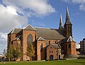
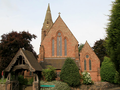
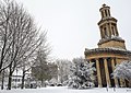
(English Romanesque) | c.1066 – c.1189 | Warwick | St Mary's Church, Stoneleigh | Place of worship |  | ~15 | ~49 | c.1180 | [567] |
| Located in the small village of Stoneleigh-in-Arden in Warwickshire, 4.5 miles (7.25 km) south of Coventry, Grade I listed Church of St Mary is one of several surviving Norman churches in the region. Built in the late 1100s, it is ambitious for its date, with its red sandstone ashlar chancel, nave and west tower. Nearby St. Mary's Church in Cubbington is of a similar age and size. |
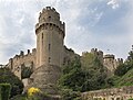
| Fortified | c.1066 – c.1485 | Warwick | Warwick Castle | Castle |  | 44 | 144 | c.1360 | [568] |
| Warwick Castle was established by William the Conqueror in 1068. Originally a motte-and-bailey castle, it was replaced by a stone keep during the reign of King Henry II (1154–1189) and later fortified by Thomas Beauchamp, 11th Earl of Warwick (1330–1360) with a gatehouse, barbican, and two main towers. Ceaser's Tower is the taller of the two towers, although Guy's Tower appears more prominent on the skyline due to its elevated setting. At a height of 44 metres (144 feet), it makes Warwick Castle the tallest medieval castle in the United Kingdom. |
| Early English Gothic | c.1189 – c.1307 | Birmingham | St Laurence's Church | Place of worship |  | ~14 | ~46 | c.1230 | [569] |
| Grade I listed Church of St Laurence in Northfield dates from the 12th century and contains some of the finest Early English work in the West Midlands. |
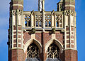
| Decorated Gothic | c.1307 – c.1377 | Wolverhampton | St Peter's Church | Place of worship |  | 37 | 120 | c.1350 | [570] |
| St Peter's Church is built of red sandstone on an elevated site in the centre of the city. The oldest part of the building above ground is the crossing under the tower, which probably dates from around 1200. Much of the Church was rebuilt and extended in the 14th century, in a Decorated style, with the upper part of the tower being rebuilt from about 1475 to a height of 37 metres (120 feet). It remained the tallest building in Wolverhampton until the completion of St John's Church in 1776. |
| Perpendicular Gothic | c.1377 – c.1547 | Coventry | The Cathedral Church of Saint Michael | Ruin |  | 88 | 289 | c1425 | [571] |
| The Old Cathedral Church of St Michael's was a 14th-century Gothic church designed in the perpendicular style. It was one of the largest parish churches in England when, in 1918, it was elevated to cathedral status on the creation of the Diocese of Coventry. This cathedral now stands ruined, having been bombed during World War II, but the spire remains the tallest in Coventry and the third tallest in England. |
| Vernacular | c.1450 – c.1630 | Sandwell | Oak House, West Bromwich | House and museum |  | ~13 | ~42 | c.1620 | [572] |
| Many of the finest examples of late medieval half-timbering in the region can be found in and around Solihull and Warwick. However, the unusual prospect tower atop Grade II* listed Oak House in West Bromwich elevates the height of this former yeoman's house above its better-known peers. Restored in 1898, the house is now run as a museum. |
Tudor
1485–1603 | Early Tudor (transitional) | c.1485 – c.1560 | Stratford-upon-Avon | Coughton Court | Country house |  | ~20 | ~66 | 1536 | [573] |
| Coughton Court is an English Tudor country house situated on the main road between Studley and Alcester in Warwickshire, built between 1509 and 1536. It is a Grade I listed building. The house has a long crenellated façade directly facing the main road, at the centre of which is the Tudor Gatehouse, dating from after 1536; this has hexagonal turrets and oriel windows in the English Renaissance style. The Gatehouse is the oldest part of the house and is flanked by later wings. |
| Fortified (Tudor) | c.1485 – c.1603 | Warwick | Leicester's Gatehouse | Castle |  | 18 | 59 | 1571 | [574] |
| Leicester's Gatehouse is one of the few parts of Kenilworth castle to remain completely intact. It was built by Robert Dudley, 1st Earl of Leicester to provide a fashionable entrance to the castle from the direction of Coventry. The external design, with its three-storey stone tower and four octagonal corner turrets, echoes the medieval fortified style popular a century or more before, while the interior is designed in the Elizabethan fashion of the time. |
| Elizabethan | c.1547 – c.1603 | Stratford-upon-Avon | Charlecote Park | Country house |  | ~16 | ~52 | 1558 | [575] |
| Charlecote Park is located on the banks of the River Avon in the village of Charlecote, on the border between Stratford-upon-Avon and Warwick districts. It was built in 1558 by Sir Thomas Lucy, and although the house was modified by successive generations of the Lucy family, the outline of the original Elizabethan house remains. It is a fine example of an Elizabethan prodigy house and a Grade I listed building. |
Stuart
1603 – 1714 | Jacobean | c.1603 – c.1630 | Birmingham | Aston Hall | Prodigy House / Museum |  | ~23 | ~75 | 1635 | [576] |
| Designed by John Thorpe and built between 1618 and 1635 for Sir Thomas Holte, Grade I listed Aston Hall is one of the last great Jacobean prodigy houses and the largest of its type in the region. Located two miles to the north of Birmingham city centre in Aston Park, it is now a community museum and visitor attraction managed by the Birmingham Museums Trust. |
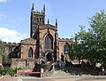
| Post-medieval Gothic (incl. Gothic Survival; Gothic-Renaissance) | c.1600 – c.1820 | Warwick | Collegiate Church of St Mary | Place of worship |  | 53 | 174 | 1704 | [577] |
| Although classically inspired architecture began to supplant Gothic in the 17th century, some regional architects continued to work in Gothic styles, employing traditional gothic designs or fusing gothic features with the classical zeitgeist. The Collegiate Church of St Mary is an outstanding example of the latter, rebuilt in 1704 in a Gothic-Renaissance style following the Great Fire of Warwick in 1693. The building was designed by William Wilson and may have been supervised by Sir Christopher Wren. Its unique 53-metre tower is gothic in appearance but incorporates classical detailing. |
| Early English Classical (incl. Cromwellian) | c.1625 – c.1660 | Redditch | Norgrove Court | Country House |  | ~15 | ~49 | 1649 | [578] |
| Norgrove Court is one of a number of classically influenced houses built across the region prior to the Restoration period of 1660. It features sandstone ashlar dressings, a hipped roof with dormer windows, and rows of sash-window bays in a quasi-Mannerist style. The vast central chimney stack raises the overall height of the building above similar houses of the period, for example Blyth Hall in Warwickshire. It is the only Grade I-listed building in the district of Redditch. |
Carolean
(Restoration) | c.1660 – c.1690 | Stratford-upon-Avon | Ragley Hall | Country House |  | ~22 | ~72 | 1683 | [579] |
| Ragley Hall is located near Alcester, around 8 km south of Redditch. It was designed for Edward Conway, 1st Earl of Conway by Roger or William Hurlbut circa 1677 and modified by the scientist and amateur architect Dr Robert Hooke in 1678. The mansion comprises a double-pile house with corner pavilions and a full-height portico supported on Ionic columns. It is a Grade I listed building and the ancestral seat of the Marquess of Hertford. |
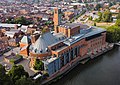
| English Baroque | c.1690 – c.1730 | Birmingham | Cathedral Church of St Philip | Place of worship |  | 40 | 131 | 1715 | [580] |
| The Cathedral Church of Saint Philip is the Church of England cathedral and the seat of the Bishop of Birmingham, having been granted cathedral status in 1905. Built between 1711 and 1715, it was the city's tallest building for 52 years, until it was supplanted by the 58 metre (190 feet) spire of Parish Church of SS Peter and Paul in 1777. It is a Grade I listed building. |
Georgian
1714 – 1837 | Neo-Palladian | c.1715 – c.1760 | Bromsgrove | Hagley Hall | Country House |  | ~23 | ~76 | 1760 | [581] |
| The fashion for Neo-Palladian houses started in London around 1720 and spread to the provinces in the years that followed. Designed by Sanderson Miller for George Lyttelton, 1st Baron Lyttelton, Hagley Hall was built between 1754 and 1760, and has been described as the last of England's great Palladian houses. Notable Neo-Palladian features include the Venetian windows and the corner towers with pyramidal roofs, which have since been restored. It is a Grade I listed building. |
| Georgian Neoclassical | c.1750 – c.1840 | Wolverhampton | Church of St John in the Square | Place of worship |  | 50 | 164 | 1776 | [582] |
| St. John's Church is a Grade II* listed Church of England parish church, built between 1758 and 1776 in the neoclassical style. It is the second oldest church in Wolverhampton City Centre and the first to be built within its own square. It is believed Roger Eykyn, who was the building contractor, used the design as a model for St. Paul's Church in Birmingham, which was built between 1777 and 1779. However, the lofty spire of St. John's is marginally the taller of the two. |
| Early Gothic Revival (incl. 'Strawberry Hill' Gothic; Gothick) | c.1750 – c.1810 | Nuneaton and Bedworth | Arbury Hall | Country House | 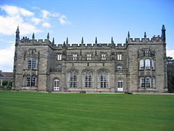 | ~12 | ~39 | 1803 | [583] |
| Arbury Hall was originally a three-storey Elizabethan house built on the site of the 12th-century Augustinian Priory of Arbury. In 1750, then owner Sir Roger Newdigate began major alterations to the property in the 18th-century Gothic Revival style, which continued until his death in 1806. The refronted mansion incorporates crenellated parapets with pinnacle finials, traceried windows and other gothic ornaments typical of the 'Strawberry Hill Gothic' style. It is a Grade I listed building. |
| Regency (Classical Revival) | c.1810 – c.1840 | Warwick | Parade, Royal Leamington Spa | Residential | 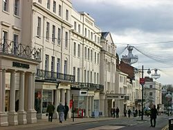 | ~20 | ~66 | 1810–1840 | [584] |
| The mineral spring bathhouses of Royal Leamington Spa became fashionable during the Regency era and this is reflected in the classical architecture of the town. Many of its grandest stucco-fronted Regency buildings are located on the main thoroughfare, Parade, although similarly proportioned residential terraces can be found around the town, including Grade II* listed Royal Terrace (formerly Newbold Terrace) and Lansdowne Circus. |
| Greek Neoclassical | c.1810 – c.1880 | Birmingham | St Thomas' Church | Ruin |  | ~40 | ~131 | 1829 | [585] |
| St Thomas' was a Commissioners' church constructed between 1826 and 1829. At the time it was the largest church in Birmingham. Although architect Thomas Rickman was noted for his contribution to Gothic revivalism, St Thomas' neoclassical design took its cues from Greek revivalism, typical of the Regency period. In 1940, the building was largely destroyed during the Birmingham Blitz. The remaining portico and tower, rising to 40 metres, have been preserved and form part of St. Thomas' Peace Garden. |
| Regency (Medieval Revival) | c.1810 – c.1840 | Birmingham | St Mary's College, Oscott | Education |  | ~26 | ~85 | 1838 | [586] |
| Grade II* listed St Mary's College is the Roman Catholic seminary of the Archdiocese of Birmingham. It was designed by Joseph Potter of Lichfield and built between 1835 and 1838. The Tudor building envisaged by Potter was supplemented by the decorative input of Augustus Pugin, forming a unique combination of medieval and Gothic Revival architecture in red brick and stone. This fusion of styles marks a step change from the early Gothic Revival of the Georgian era to the High Victorian Gothic of the mid-to-late 19th century. |
Victorian
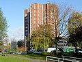
1837 – 1901 | Romanesque Revival | c.1840 – c.1925 | Nuneaton and Bedworth | Bedworth Water Tower | Water Tower |  | 45 | 148 | 1898 | [587] |
| This Grade II listed former water tower was built in 1898 provide the people of Bedworth with clean drinking water. Designed in a simplified Romanesque style, its six high-storey bond brick tower and steep pagoda-style roof make it the tallest free-standing structure in the Nuneaton and Bedworth district. In 2015 the tower was sold to be converted into luxury apartments, but development is yet to begin. |
| Victorian Gothic Revival (incl. Early English; Decorated; Perpendicular) | c.1840 – c.1900 | Birmingham | St Martin in the Bull Ring | Place of worship |  | 61 | 200 | 1855 | [588] |
| St Martin in the Bull Ring is the original parish church of Birmingham and stands between the Bull Ring Shopping Centre and the markets. The present Victorian Gothic church was rebuilt by architect J. A. Chatwin on the site of a 13th-century predecessor, although the eighteenth-century tower and spire were preserved. St Martin's supplanted the Church of SS Peter & Paul in Aston as the tallest building in Birmingham, which it remained for 53 years. |
| Renaissance Revival (incl. Italianate; Neo-Baroque) | c.1850 – c.1890 | Birmingham | Birmingham Museum and Art Gallery | Civic building |  | 45 | 148 | 1885 | [589] |
| Birmingham Museum and Art Gallery was built to extend the Council House, which had been completed in 1879. Designed by Yeoville Thomason, the building follows the Neo-Baroque design of the Council House, with entry through a two-storeyed portico with sculptured pediment. Directly to the left of the entrance is the 45-metre clock tower with tiled roof known locally as 'Big Brum'. |
| High Victorian Gothic (Ruskinian Gothic) (incl. French and Italian styles) | c.1850 – c.1880 | Wolverhampton | St Luke's Church | Place of worship |  | 52 | 170 | 1861 | [590] |
| St Luke's Church is a Grade II* listed parish church designed in the Ruskinian style by G. T. Robinson of Leamington Spa, and consecrated by the Bishop of Lichfield on 18 July 1861. At 52 metres, its polychrome spire with Gothic detailing is the tallest structure of its type in the region, surpassing those exemplified by Martin & Chamberlain's Birmingham Board Schools such as Oozells Street and Icknield Street. |
| Eclectic | c.1860 – c.1910 | Birmingham | Methodist Central Hall | Hall |  | 56 | 131 | 1904 | [591] |
| Methodist Central Hall is a Grade II* listed red brick and terracotta building located at the northern end of Corporation Street. It was built between 1903 and 1904 to complement the Victoria Law Courts on the opposite side of the street, but unlike the Victorian-gothic courts is built in an eclectic style with baroque detailing, swinging voussoirs, paired ionic columns, domed corner turrets and a 56-metre tower rising to a square belfry. The main hall was designed to seat 2,000 people but the building has remained empty since 2015. |
| British Arts and Crafts movement (incl. British Queen Anne Revival) | c.1870 – c.1940 | Birmingham | St Agatha's Church | Place of worship |  | 37 | 120 | 1901 | [592] |
| Designed by the noted Birmingham architect, William Bidlake, St Agatha's church is an expression of the Arts & Crafts approach to Gothic architecture at the end of the 19th century, combining red and blue brick with decorative stone features. It is a Grade I listed building. |
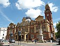
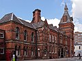
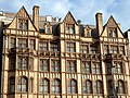
| Tudor Revival (incl. Old English; Mock Tudor; Tudorbethan) | c.1890 – c.1920 | Coventry | Old Council House | Government |  | ~32 | ~105 | 1917 | [593] |
| The Grade II-listed Coventry Council House was designed in the Elizabethan style by Edward Garrett and Henry Walter Simister. The building is faced in stone and decorated with turrets and crenellations, oriel and bay windows, and a corner clock tower rising to a height of around 32 metres, making it the tallest example of Tudor Revival architecture in the region. |
Edwardian
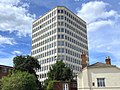
1901 – 1910 | Edwardian Classicism (incl. Edwardian Baroque) | c.1901 – c.1914 | Birmingham | Joseph Chamberlain Memorial Clock Tower | Education |  | 100 | 131 | 1908 | [594] |
| Forming the centrepiece of Chancellor's Court on the University of Birmingham's main campus, "Old Joe" was designed by architects Aston Webb and Ingress Bell and constructed between 1900 and 1908, helping to popularise the term "Red Brick" university. The 100-metre campanile was modelled on the Torre del Mangia in Siena and remained the tallest building in Birmingham until 1965. |
Modern
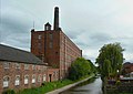
1910 – 2000 | Industrial | c.1910 – c.1950 | South Staffordshire | Baggeridge Brick Chimney | Chimney |  | 65 | 213 | c.1937 | [595] |
| In 1937, Baggeridge Brickworks was built next to the Earl of Dudley's coal pits at Gospel End, Sedgely, and continued to manufacture bricks until its takeover by Wienerberger AG in 2007. The site has since been transformed into a craft village and residential development adjacent to Baggeridge Country Park, and the 65-metre (213 feet) chimney remains one of the few visual reminders of the area's industrial past. It is the tallest structure of its type in the region. |
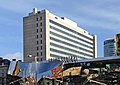
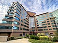
| Art Deco | c.1920 – c.1940 | Birmingham | Heritage Building (Queen Elizabeth Hospital) | Education |  | ~54 | ~177 | 1938 | [167] |
| The main building, including the clock tower, was constructed between 1933 and 1938 as a wing of the old Birmingham Queen Elizabeth Hospital. The new 600-bed Hospital Centre building was designed by architectural firm Lanchester and Lodge. Completed in 1938, the medical school building and hospital opened simultaneously. |
| Functionalist | c.1930 – c.1980 | Birmingham | BT Tower | Communications Tower |  | 152 | 499 | 1965 | [596] |
| BT Tower is currently the tallest non-building structure in Birmingham city centre. Construction of the tower commenced in July 1963 and was completed in September 1965. At one time the Post Office wanted to increase the height from 500 feet (150 m), which had been agreed by the Ministry of Aviation, to 600 feet (180 m), but this was refused to avoid non-standard procedures for aircraft on the approach to Birmingham Airport. |
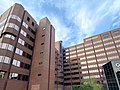
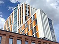
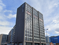
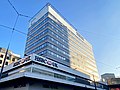
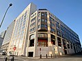
| International Style | c.1930 – c.1980 | Birmingham | McLaren Building | Office |  | 69 | 226 | 1972 | [597] |
| The 21-storey McLaren Building characterises the rectangular footprint, box-shaped form and grid-like glass and steel facade of the post-war, international-style commercial high rise. Designed by Paul Bonham Associates and built in 1972 for HSBC, the thin, brown-tinted slab is currently the 21st tallest occupied building in Birmingham. |
| Brutalist | c.1950 – c.1980 | Birmingham | Centre City Tower | Office |  | 76 | 249 | 1975 | [598] |
| The tallest of several remaining Brutalist office buildings in the centre of Birmingham, Centre City was designed by Richard Seifert & Partners. The complex consists of two buildings, the Tower and the Podium. The Podium is a low-rise building that surrounds the Tower base, but (with the exception of fire escapes) there is no direct connection between the two. This arrangement means that the first floor of the Tower is at approximately seventh-floor level when compared with other buildings. |
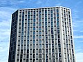
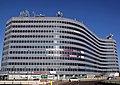
| Late Modernist | c.1950 – c.1980 | Birmingham | Alpha Tower | Office |  | 100 | 328 | 1973 | [599] |
| Alpha Tower is a Grade II listed office skyscraper designed by the Birmingham-born architect George Marsh of Richard Seifert & Partners and was the former headquarters of ATV (Associated Television). Marsh's architectural influences are said to have included Le Corbusier, Oscar Niemeyer and the American architectural practice Skidmore, Owings & Merrill, marking a departure from the Brutalist movement of the time. Prior to the completion of 103 Colmore Row in 2021, Alpha Tower was the tallest commercial building in the city and one of only three commercial buildings outside of London to reach a height of 100 metres. |
Structural Expressionist
(High-tech) | c.1960 – present | Birmingham | International Convention Centre (ICC) | Conference facility |  | ~25 | ~82 | 1991 | [600] |
| The International Convention Centre (ICC) is a major conference venue owned and operated by the NEC Group. Designed by Percy Thomas Partnership, the main entrance is marked by blue-tinted windows and exposed stanchions, while inside the building, connecting bridges and walkways criss-cross the atrium. The centre incorporates Symphony Hall, which has since been redesigned with a dedicated front entrance. |
Postmodern
1970 – present | International Postmodern | c.1970 – c.2000 | Birmingham | Colmore Gate | Office |  | 70 | 230 | 1992 | [601] |
| One of the few tall buildings to be constructed in Birmingham during the 1980s and 1990s, Colmore Gate draws on Art Deco features within its postmodern aesthetic. Its glazed appearance bears a notable resemblance to Philip Johnson's PPG Place in Pittsburg. |
| New Classical (Neotraditional; Neohistoric) | c.1970 – Present | Birmingham | Three Brindleyplace | Mixed-use |  | 55 | 180 | 1998 | [602] |
| Brindleyplace is a large mixed-use canalside development in the Westside district of Birmingham. A variety of architects were commissioned to design buildings in a range of architectural styles. Situated between the canal and Central Square, Three Brindleyplace was designed by Demetri Porphyrios, an exponent of New Classical Architecture, and this is reflected in the Venetian Palazzo-style facade of the building. Its 55-metre (180 feet) clock tower makes it the second tallest building in the complex. |
| Deconstructive | c.1980 – Present | Birmingham | The Cube | Mixed-use |  | 71 | 231 | 2010 | [603] |
| The Cube is a 25-storey mixed-use development in the centre of Birmingham, designed by Ken Shuttleworth of Make Architects. In an ironic postmodern twist, the outer cladding – a kaleidoscope of glazed and gold colour anodised aluminium panels – obscures the fact that the building is not, in fact, cuboid, but a deconstructed crown sitting atop a glazed atrium. |
Contemporary
2000 – Present | Sustainable | c.2000 – Present | Coventry | Lanchester Library | Education |  | ~30 | ~98 | 2000 | [604] |
| Opened in September 2000 on the Coventry University campus, the Frederick Lanchester Library is the largest deep-plan stack-ventilated building in Europe. The library, conceptualised by Short & Associates, is designed to maximise the use of natural daylight and features sustainable power and network infrastructures. The building's 30-metre elevated air-conditioned vents are fundamental to its energy saving design. |
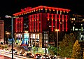
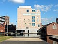
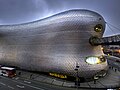
| Biomorphic | c.2000 – Present | Birmingham | Selfridges Building | Retail | 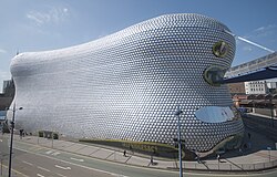 | ~35 | ~115 | 2003 | [605] |
| Designed by British-based Czech architect Jan Kaplický of (Future Systems), the iconic building is the part of the Bullring Shopping Centre that houses the Selfridges Department Store. It is one of the world's leading examples of "Blobitecture", a neofuturist architectural movement based on amoeba-shaped forms. Its biomorphic façade comprises 15,000 anodised aluminium discs mounted on a blue background. |
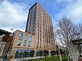
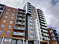
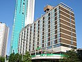
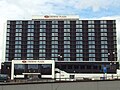
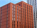
| Modular | c.2000 – Present | Wolverhampton | Victoria Hall | Student accommodation |  | 76 | 249 | 2009 | [606] |
| Victoria Hall is a modular complex comprising four blocks of student accommodation, the tallest of which is 25 stories. When the building was completed in 2009, it held the world record for overall height and number of stories in a residential building constructed principally off-site. It remains the tallest modular structure in the Birmingham metropolitan area and the tallest habitable building in Wolverhampton. |
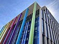
| Neofuturist | c.2000 – Present | Birmingham | Bournville College | Education |  | 30 | 99 | 2011 | [607] |
| Designed by global architecture and design practice Broadway Malyan, this landmark campus in Longbridge is set in 4.2 acres of grounds on the site of the former MG Rover automobile factory and is home to 15,000 students. The building is hinged around a linear central spine which houses classrooms, and is described as one of the most contemporary learning environments in Europe. |
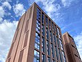
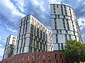
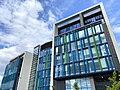
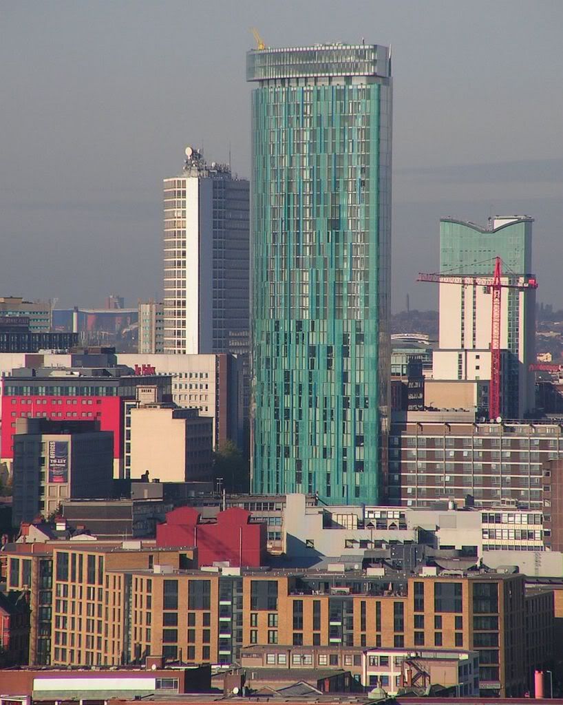
| Neomodern | c.2000 – Present | Birmingham | The Mercian | Residential |  | 132 | 433 | 2021 | [608] |
| Designed by Glenn Howells Architects, The Mercian (right) is a 42-storey skyscraper located on Broad Street in the Westside district of Birmingham. It is the third tallest habitable building, and fourth tallest built structure, in the Birmingham metropolitan area. |
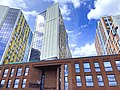
| Neobrutalism | c.2010 – Present | Birmingham | Octagon | Residential |  | 155 | 509 | 2025 | [609] |
| Designed by Glenn Howells Architects, Octagon is a 155 m (509 ft) tall, 49-storey residential skyscraper in Birmingham City Centre, which forms part of the Paradise redevelopment scheme. As of September 2025 it is the joint-tallest building in the Birmingham metropolitan area and according to its developers is the first pure octagonal residential skyscraper in the world. |
|


