Metchley Fort

Last updated

Metchley Fort
MetchleyFortEarthworks.jpg
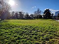
The site of the praetentura, pictured here in 2009
West Midlands UK location map.svg
Red pog.svg
Founded during the reign of Claudius
Foundedc.AD 48
Abandonedc.AD 200
Place in the Roman world
Province Britannia
Directly connected to Icknield Street
Structure
— Second fort structure —
Built during the reign of Domitian
BuiltAD 90
— Timber structure —
Built during the reign of Claudius
Builtc.AD 48
Stationed military units
Legions
Legio XIV Gemina and Legio XX Valeria Victrix
Events Boudican revolt (possibly)
Location
Coordinates Coordinates: 52°27′01″N1°56′17″W / 52.4504°N 1.938°W / 52.4504; -1.938
Place name Metchley
Town Birmingham
County West Midlands
CountryEngland
Reference
UK-OSNG referenceSN643564
Site notes
Discovery yearc.1781
ConditionEarthworks, crop marks and ditches
Controlled by Scheduled Monument (SAM: CD129)
Excavation dates1934-present
Archaeologists Mick Aston

Metchley Fort was a Roman fort in what is now Birmingham, England. [1] It was built across four phases using a north-to-south plan.

Contents

History

Roman era (c.AD 48c.AD 200)

It lies on the course of a Roman road, Icknield Street, which is now the site of the present Queen Elizabeth Hospital and the University of Birmingham in Edgbaston. The fort was constructed on the orders of Publius Ostorius Scapula soon after the Roman invasion of Britain, roughly in AD 48. [2] The fort was around 200 square metres (2,153 sq ft) in area and was defended by a turf and earth bank with a timber wall, towers and double ditches. [3] Within the fort were timber buildings including barrack blocks, a granary, a workshop and a store. In AD 60 or 61, Metchley Fort may have been involved in the Boudican Revolt, and in AD 70, the fort was abandoned, only to be reoccupied around AD 90, when another fort, half the size of the original, was built on the same site, before being abandoned again in AD 120. It would have then likely been in sporadic use as a training camp up until its complete abandonment by c.AD 200.

Remains have also been found of a civilian settlement, or vicus alongside the fort. It consisted of timber buildings and yards alongside a road leading from the fort's west gate, and was occupied for just a few years, when the fort was at its largest. [3]

The remains of Metchley Fort as shown on the 1890 Ordnance Survey map of Warwickshire. The footbridge over the railway is now the site of University railway station Metchley 1890.png
The remains of Metchley Fort as shown on the 1890 Ordnance Survey map of Warwickshire. The footbridge over the railway is now the site of University railway station

The fort was extended on three sides by the addition of defended annexes, which were used for tethering horses, storage and small-scale industrial activity such as ironworking. Later, the fort's buildings were replaced by other structures including compounds which suggest that it was now being used as a stores depot. [3]

Post-medieval era (16th century c.1781)

A hunting lodge was present on the site of Metchley Fort as early as the 16th century, likely near the retentura and latera praetorii. It was eventually demolished around 1781 when the earthworks of the fort were first identified.

Discovery and excavations (c.1781 present)

The remains were first identified around 1781 by William Hutton (he published his findings on Metchley Fort in his History of Birmingham), [4] although there were conflicting opinions on the origins of the earthworks - the common consensus at the time agreed that the fort was Norse in origin. [4] The fort was confirmed to date to the 1st and 2nd century AD in excavations that took place in the 1930s, starting in 1934, when the University of Birmingham Medical School was constructed. Further excavations took place in the 1940s and 1950s. [1] On 28 September 1953 the Lord Mayor of Birmingham, G. H. W. Griffith, opened the newly restored north-west corner of the fort. The reconstruction of the corner did not last long, however, as it was later destroyed by vandals before 1956. [5] More extensive excavations took place in the 1960s which uncovered various timber buildings within the fort. Mick Aston, who later became well-known on the TV programme Time Team, worked on the Metchley excavations in the late 1960s. Discoveries from excavations in the early 2000s included ovens and hearths, timber gateways, roads, the headquarters building, vessels from the Severn Valley and the Malvern Hills, and tableware from France. [1]

The remains of the fort are one of thirteen scheduled monuments in Birmingham. [6]

Related Research Articles

<span class="mw-page-title-main">Icknield Street</span> Roman road in England

Icknield Street or Ryknild Street is a Roman road in England, with a route roughly south-west to north-east. It runs from the Fosse Way at Bourton on the Water in Gloucestershire to Templeborough in South Yorkshire. It passes through Alcester, Studley, Redditch, Metchley Fort, Birmingham, Sutton Coldfield, Lichfield, Burton upon Trent and Derby.

<span class="mw-page-title-main">Wansdyke</span> Early medieval defensive linear earthworks in the West Country of England

Wansdyke is a series of early medieval defensive linear earthworks in the West Country of England, consisting of a ditch and a running embankment from the ditch spoil, with the ditching facing north.

<span class="mw-page-title-main">Richborough Castle</span> Ancient fort in Kent, England

Richborough Castle is a Roman Saxon Shore fort better known as Richborough Roman Fort. It is situated in Richborough near Sandwich, Kent. Substantial remains of the massive fort walls still stand to a height of several metres.

<span class="mw-page-title-main">Mamucium</span> Former Roman fort in the Castlefield area of Manchester in North West England

Mamucium, also known as Mancunium, is a former Roman fort in the Castlefield area of Manchester in North West England. The castrum, which was founded c. AD 79 within the Roman province of Roman Britain, was garrisoned by a cohort of Roman auxiliaries near two major Roman roads running through the area. Several sizeable civilian settlements containing soldiers' families, merchants and industry developed outside the fort. The area is a protected Scheduled Ancient Monument.

Alchester is the site of an ancient Roman town. The site is not included in any ancient references so the Roman name is not known. However, Eilert Ekwall contended that it appears as Alavna in the Ravenna Cosmography, with the addition of the Old English ceaster to signify a Roman fort. It lies about 2 miles (3 km) south of Bicester, in the northwest corner of the civil parish of Wendlebury in the English county of Oxfordshire.

<span class="mw-page-title-main">Piercebridge Roman Fort</span> Roman fort in Durham, England

Piercebridge Roman Fort is a scheduled ancient monument situated in the village of Piercebridge on the banks of the River Tees in modern-day County Durham, England. There were Romans here from about AD 70 until at least the early 5th century. There was an associated vicus and bath house at Piercebridge, and another vicus and a villa south of the river at Cliffe. The Victorians used carved stones from this site when they built St Mary's church at Gainford. Part of the site is under Piercebridge village green.

<span class="mw-page-title-main">Castleshaw Roman Fort</span> Roman camp in Greater Manchester, England

Castleshaw Roman fort was a castellum in the Roman province of Britannia. Although there is no evidence to substantiate the claim, it has been suggested that Castleshaw Roman fort is the site of Rigodunum, a Brigantian settlement. The remains of the fort are located on Castle Hill on the eastern side of Castleshaw Valley at the foot of Standedge but overlooking the valley. The hill is on the edge of Castleshaw in Greater Manchester. The fort was constructed in c. AD 79, but fell out of use at some time during the 90s. It was replaced by a smaller fortlet, built in c. 105, around which a civilian settlement grew. It may have served as a logistical and administrative centre, although it was abandoned in the 120s.

<span class="mw-page-title-main">Bremetennacum</span> Ruins of a Roman fort in Ribchester, England

Bremetennacum, or Bremetennacum Veteranorum, was a Roman fort on the site of the present day village of Ribchester in Lancashire, England. The site is a Scheduled Monument.

<span class="mw-page-title-main">Vinovia</span> Roman fort in County Durham, England

Vinovia or Vinovium was a Roman fort and settlement situated just over 1 mile (1.6 km) to the north of the town of Bishop Auckland on the banks of the River Wear in County Durham, England. The fort was the site of a hamlet until the late Middle Ages, but the modern-day village of Binchester is about 2 miles (3 km) to the east, near Spennymoor. The ruins are now known as the Binchester Roman Fort.

<span class="mw-page-title-main">Condercum</span> Roman fort in England

Condercum was a Roman fort on the site of the modern-day Condercum Estate in Benwell, a suburb of Newcastle upon Tyne, England. It was the third fort on Hadrian's Wall, after Segedunum (Wallsend) and Pons Aelius (Newcastle), and was situated on a hilltop 2 miles (3 km) to the west of the city.

<span class="mw-page-title-main">Branodunum</span>

Branodunum was an ancient Roman fort to the east of the modern English village of Brancaster in Norfolk. Its Roman name derives from the local Celtic language, and may mean "fort of the raven".

Pennocrucium was a Romano-British settlement and military complex located at present day Water Eaton, just south of Penkridge, Staffordshire, with evidence of occupation from the mid-1st century until the 4th century.

<span class="mw-page-title-main">Buckland Rings</span> Iron Age hillfort in Hampshire, England

Buckland Rings is the site of an Iron Age hill fort in the town of Lymington, Hampshire. Today, the mounds and dykes around the outside which once constituted its defences are still clearly visible, although the outer bank lies under the road on the west side, and on the south-east it is nearly ploughed-out. Excavations of the inner and middle ramparts in 1935 revealed that they were of wall-and-fill construction, retained at the front by upright timber beams and walls of cut and laid turf. The entrance, which lies on the east side, was also excavated revealing a long entrance passage and the postholes for a pair of stout gateposts. The site was bought by Hampshire County Council in 1989 to ensure its preservation, and it is open to the public from the A337 road onto which part of it faces.

Trawscoed fort is a Roman auxiliary fort in Ceredigion, Wales, located near the modern settlement of Trawsgoed and is cut through by the modern B4340 road. It was first built in the 70s AD. and was occupied until around 130 AD, housing up to 800 infantry in rows of barracks within the 2.1 hectares banked enclosure. At its height it could have had a total population of around 2,000 people living at the fort and its extramural vicus. It overlooks the Roman bridge over the River Ystwyth, which is where the road from Pen-Ilwyn to Llanio crosses. In 1959, this site was initially identified via aerial photography revealing a series of parchmarks covering an area of around 20,000 square metres (2 ha). Later explorations increased the knowledge of this site.

<span class="mw-page-title-main">Caister Roman Site</span> Roman Saxon Shore fort, located in Caister-on-Sea, Norfolk

Caister Roman Site is a Roman Saxon Shore fort, located in Caister-on-Sea, Norfolk, England. It was constructed around AD 200 for a unit of the Roman army and navy and occupied until around 370-390 AD. This fort was possibly known as Gariannonum, although the single record that describes it as such may also mean the Roman site at Burgh Castle.

<span class="mw-page-title-main">Nida (Roman town)</span>

Nida was an ancient Roman town in the area today occupied by the northwestern suburbs of Frankfurt am Main, Germany, specifically Frankfurt-Heddernheim, on the edge of the Wetterau region. At the time of the Roman empire, it was the capital of the Civitas Taunensium. The name of the settlement is known thanks to written sources from Roman times and probably derives from the name of the adjacent river Nidda.

<span class="mw-page-title-main">Derventio Brigantum</span> Ancient Roman fort in present-day North Yorkshire, England

Derventio, sometimes described as Derventio Brigantium in order to distinguish it from other places called Derventio, was a Roman fort and settlement located beneath the modern town of Malton in North Yorkshire, England. The fort is positioned 18 miles north-east of Eboracum on the River Derwent.

<span class="mw-page-title-main">Navio Roman Fort</span> Roman fort near Hope in Derbyshire, England

Navio Roman fort overlooks a tight bend of the River Noe at Brough-on-Noe near Hope, Derbyshire, in England. Navio fort and vicus is a Scheduled Monument.

<span class="mw-page-title-main">Lancaster Roman Fort</span> Roman fort in Lancaster, England

Lancaster Roman Fort, also known as Wery Wall, Galacum or Calunium, is the modern name given to ruined former Roman fort atop Castle Hill in Lancaster in North West England. The first castra was founded c. 80 AD within the Roman province of Britannia.

<span class="mw-page-title-main">Over Burrow Roman Fort</span> Roman fort in Burrow-with-Burrow, Lancaster, England

Over Burrow Roman Fort is the modern name given to a former Roman fort at Over Burrow, Lancashire in North West England. Today it is the site of the 18th-century country house Burrow Hall. The first castra is thought to have been founded in the first century AD within the Roman province of Britannia.

References

  1. 1 2 3 "Birmingham's Roman Fort (Metchley)". Birmingham City Council. Archived from the original on 10 May 2008. Retrieved 24 May 2008.
  2. "Metchley Roman Fort". Historic England. Retrieved 7 April 2017.
  3. 1 2 3 "Birmingham's Roman Fort (Metchley) Main Findings". Birmingham City Council. Archived from the original on 11 May 2008. Retrieved 25 May 2008.
  4. 1 2
  5. Victor Skipp, The History of Greater Birmingham - down to 1830, 1987, V. H. T. Skipp ( ISBN   0-9506998-0-2)
  6. "Birmingham's Scheduled Ancient Monuments". Birmingham City Council. Archived from the original on 10 May 2008. Retrieved 25 May 2008.