List of tallest buildings and structures in Barrow-in-Furness

Last updated

Walney Wind Farm, currently the tallest structure in Barrow-in-Furness. Walney Offshore Windfarm - geograph.org.uk - 2391702.jpg
Walney Wind Farm, currently the tallest structure in Barrow-in-Furness.

This list of the tallest buildings and structures in borough of Barrow-in-Furness ranks buildings in the city by height.

Contents

There are a diverse range of tall structures within the borough, the tallest of which being the wind farms of Ormonde Wind Farm, Walney Wind Farm and the Barrow Offshore Wind Farm. The industrial past of the town is the Roosecote Power Station and the Devonshire Dock Hall are also prominent structures. The tallest habitable building is the town hall at a height of 50 metres whilst the tallest office building is the 34 metre Craven House.

There are currently no further building or structures over 25 metres either under construction, approved or proposed for Barrow-in-Furness.

Completed

This lists buildings in Barrow-in-Furness that are at least 25 m (82 ft) tall.

An equal sign (=) following a rank indicates the same height between two or more buildings.

RankNameImageHeight
m (ft)
FloorsYear completedPrimary useNotes
1 Walney Wind Farm Walney Offshore Windfarm - geograph.org.uk - 2391702.jpg 120 (394)N/A2011Wind farmThe tallest structure in Barrow-in-Furness and in Cumbria and the world's largest operational offshore wind farm. Hub heights reach 120 metres. [1]
2 Ormonde Wind Farm Vattenfall REpower 5M offshore wind turbine.jpg 100 (328)N/A2011Wind farmThe second tallest structure in Barrow-in-Furness and in Cumbria. Hub heights reach 100 metres. [2]
3 Barrow Offshore Wind Farm Barrow Offshore wind turbines NR.jpg 75 (246)N/A2006Wind farmThe third tallest structure in Barrow-in-Furness and in Cumbria. Hub heights reach 75 metres. [3]
4 Devonshire Dock Hall DDH Barrow.jpg 51 (167)N/A1986IndustrialDevonshire Dock Hall is a large indoor shipbuilding and assembly complex that forms part of the BAE Systems shipyard. [4]
5 Barrow-in-Furness Town Hall Town Hall, Barrow.jpg 50 (164)61886GovernmentBarrow-in-Furness Town Hall is a Victorian-era, neo-gothic municipal building in the central business district of Barrow-in-Furness. The building serves as the base of Barrow Borough Council. [5]
6 St. James' Church St James' Church, Barrow.jpg 46 (150)N/A1869ReligionSt. James Church belongs to the Church of England's Diocese of Carlisle within the ecclesiastical Province of York. The present church building dates from the mid-19th century and is a Grade II listed building. [6]
7 Furness Abbey Furness Abbey 01.jpg 40 (131)N/A1450ReligionFurness Abbey is a former Catholic monastery dating back to 1123 and was once the second-wealthiest and most powerful Cistercian monastery in the country, behind Fountains Abbey, prior to its dissolution during the English Reformation. The abbey contains a number of individual Grade I Listed Buildings. [7]
8 Furness Academy North Site Tower Furness Academy North Site.jpg 37 (120)71970EducationFurness Academy is a secondary school for over 750 students. [8]
9 Craven House Craven House, Barrow 2.jpg 34 (112)71967OfficeAt 7 floors, Craven House is the tallest office building in Barrow-in-Furness. [9]

Demolished

This lists buildings and structures in Barrow-in-Furness that were at least 25 m (82 ft) tall and have since been demolished.

RankNameImageHeight
m (ft)
FloorsYear completedYear demolishedPrimary useNotes
1 Roosecote Power Station Rooscote Power Station, Barrow-in-Furness.jpg 63 (207)N/A19912015ChimneyWas the tallest structure in Barrow-in-Furness. Demolished in 2015. [10]

See also

Related Research Articles

<span class="mw-page-title-main">Barrow-in-Furness</span> Town in Cumbria, North-West England

Barrow-in-Furness is a port town in Cumbria, England. Historically in Lancashire, it was incorporated as a municipal borough in 1867 and merged with Dalton-in-Furness Urban District in 1974 to form the Borough of Barrow-in-Furness. At the tip of the Furness peninsula, close to the Lake District, it is bordered by Morecambe Bay, the Duddon Estuary and the Irish Sea. In 2011, Barrow's population was 56,745, making it the second largest urban area in Cumbria after Carlisle. Natives of Barrow, as well as the local dialect, are known as Barrovian.

Morecambe Bay is a large estuary in northwest England, just to the south of the Lake District National Park. It is the largest expanse of intertidal mudflats and sand in the United Kingdom, covering a total area of 120 sq mi (310 km2). In 1974, the second largest gas field in the UK was discovered 25 mi (40 km) west of Blackpool, with original reserves of over 7 trillion cubic feet (tcf). At its peak, 15% of Britain's gas supply came from the bay but production is now in decline. It is also one of the homes of the high brown fritillary butterfly.

<span class="mw-page-title-main">Walney Island</span> Island in the United Kingdom

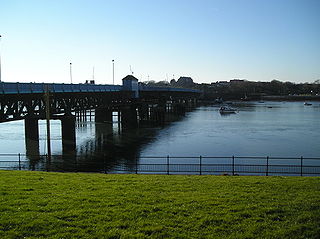
Walney Island, also known as the Isle of Walney, is an island off the west coast of England, at the western end of Morecambe Bay in the Irish Sea. It is part of Barrow-in-Furness, separated from the mainland by Walney Channel, which is spanned by the Jubilee Bridge. Walney is the largest island of the Furness Islands group, both in population and size, as well as the largest English island in the Irish Sea. Its population at the 2011 UK Census was 10,651, distributed evenly across the island's two Wards of Walney North and Walney South.

<span class="mw-page-title-main">Barrow Island, Barrow-in-Furness</span> Area and electoral ward of Barrow-in-Furness, Cumbria, England

Barrow Island is an area and electoral ward of Barrow-in-Furness, Cumbria, England. Originally separate from the British mainland, land reclamation in the 1860s saw the northern fringes of the island connected to Central Barrow. Barrow Island is also bound to the south and east by the town's dock system and to the west by Walney Channel. The Ward population taken at the 2011 census was 2,616.

<span class="mw-page-title-main">Barrow Offshore Wind Farm</span> Offshore wind farm in the East Irish Sea near Barrow-in-Furness, Cumbria, England

The Barrow Offshore Wind Farm is a 30 turbine 90MW capacity offshore wind farm in the East Irish Sea approximately 7 kilometres (4.3 mi) south west of Walney Island, near Barrow-in-Furness, Cumbria, England.

<span class="mw-page-title-main">Hindpool</span> Human settlement in England

Hindpool is an area and electoral ward of Barrow-in-Furness, Cumbria, England. It is bordered by Barrow Island, Central Barrow, Ormsgill, Parkside and the Walney Channel, the local population stood at 5,851 in 2011. The ward covers the entire western half of the town centre and includes Barrow's main shopping district. Other local landmarks include the Furness College Channelside campus, the Dock Museum and the Main Public Library. Hindpool is also home to two stadia - Barrow Raiders' Craven Park and Barrow A.F.C.'s Holker Street.

<span class="mw-page-title-main">Ormonde Wind Farm</span> Wind farm in the Irish Sea

The Ormonde Wind Farm is a wind farm west of Barrow-in-Furness in the Irish Sea. The wind farm covers an area of 8.7 square kilometres (3.4 sq mi). It has a total capacity of 150 MW and is expected to produce around 500 GWh of electricity per year.

<span class="mw-page-title-main">Port of Barrow</span> Port in United Kingdom

The Port of Barrow refers to the enclosed dock system within the town of Barrow-in-Furness, England. Morecambe Bay is to the east of the port and the Irish Sea surrounds it to the south and west. The port is currently owned and operated by Associated British Ports Holdings, but some land is shared with BAE Systems Submarine Solutions. Currently consisting of four large docks, the Port of Barrow is one of North West England's most important ports. The docks are as follows: Buccleuch Dock, Cavendish Dock, Devonshire Dock and Ramsden Dock. The port of Barrow is the only deep water port between the Mersey and the Clyde.

<span class="mw-page-title-main">Barrow-in-Furness Town Hall</span> Municipal building in Barrow-in-Furness, Cumbria, England

Barrow-in-Furness Town Hall is a Gothic Revival style municipal building in Barrow-in-Furness, Cumbria, England. The building, which serves as the base of Barrow Borough Council, lies within a Conservation Area with Grade II* listed status.

<span class="mw-page-title-main">Craven House</span>

Craven House is a large office building in Barrow-in-Furness, Cumbria, England located on Michaelson Road close to the eponymous bridge. Constructed in the 1960s the building is noted for its length of roughly 90 m (300 ft) and consists of seven floors making it one of the tallest storied buildings in the town. The gross floor area stands at around 8,100 square metres (87,000 sq ft). Craven House is owned by the Department of Work and Pensions through Barrow Borough Council and currently houses the town's principal Jobcentre alongside leasing office space to the headquarters of successful shipping company James Fisher & Sons - the only Barrow based company listed on the London Stock Exchange.

<span class="mw-page-title-main">The Waterfront Barrow-in-Furness</span> Place in Cumbria, England

The Waterfront Barrow-in-Furness is a £200 million development under construction in and around the Port of Barrow, England. The site covers an area of some 400 acres (160 ha) and was due for completion in 2020. The internal road network is already complete, with construction of a large business park complex ongoing and work on a 400-berth marina and 650 home Marina Village due to start thereafter. In 2010, The Waterfront Barrow-in-Furness ranked as the ninetieth most costly regeneration project in the United Kingdom by Regeneration & Renewal. Progress on the project stalled between 2010 and 2016 due to complications with funding following the disabandonment of the North West Regional Development Agency. BAE Systems opened a large logistics warehouse named the Resolution Building on Dova Way within the designated Business Park Area in October 2016, while and construction of a new access road from Salthouse Road to the Marina Village commenced in May 2017.

<span class="mw-page-title-main">West of Duddon Sands Wind Farm</span>

West of Duddon Sands Wind Farm (WoDS), occasionally also known as West Duddon Wind Farm is an offshore wind farm located 14 kilometres (8.7 mi) south west of Walney Island off the coast of Barrow-in-Furness in Cumbria, in the Irish Sea, England. It was developed by Scottish Power and Ørsted A/S.

<span class="mw-page-title-main">Walney Wind Farm</span> Offshore wind farm off the coast of Cumbria, England

Walney Wind Farms are a group of offshore wind farms 9 miles (14 km) west of Walney Island off the coast of Cumbria, in the Irish Sea, England. The group, operated by Ørsted, consists of Walney Phase 1, Phase 2 and the Walney Extension. The extension has a capacity of 659 MW making it the world's second largest offshore wind farm.

<span class="mw-page-title-main">Earnse Bay</span>

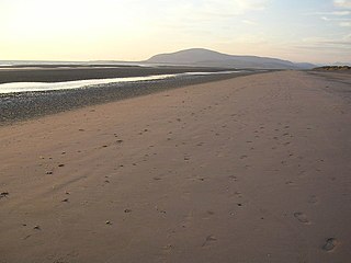
Earnse Bay is a sand and shingle beach located along the western side of Walney Island in the Borough of Barrow-in-Furness, Cumbria, England. Along with Sandy Gap and Biggar Bank, Earnse Bay forms a more or less continuous stretch of eight miles of coastline. The beach offers panoramic views of the Irish Sea, the Isle of Man and the Lake District mountains which have only recently been interrupted by the construction of three large wind farms. Earnse Bay was once planned to be developed into a reputable seaside resort to rival other nearby towns such as Morecambe and Blackpool, however these plans never fully materialised. Despite this, Earnse Bay remains Barrow's most popular beach and is busy with walkers, sunbathers and kitesurfers during the summer months.

The following is a timeline of the history of Barrow-in-Furness, England, United Kingdom.

West of Walney is a Marine Conservation Zone in the Irish Sea west of Walney Island, England. It was designated in 2016 to protect subtidal mud and sand habitats: at that time the MCZ was one of three off the coast of Cumbria, the others being Allonby Bay and Cumbria Coast. The area is 388km2, a similar size to the Isle of Wight off the south coast of England. The depth range of the site is 15–33 metres.

References

  1. "Walney Extension offshore wind farm".
  2. "Ormonde Wind Farm". Archived from the original on 1 October 2012. Retrieved 11 April 2011.
  3. Barrow Offshore Wind Farm
  4. "Devonshire Dock Hall". Archived from the original on 4 April 2011. Retrieved 11 April 2011.
  5. "Barrow BC - Contact Us". Archived from the original on 4 July 2016.
  6. St. James' Church
  7. Furness Abbey
  8. "Furness Academy School – Barrow in Furness".
  9. Craven House Archived 2011-08-20 at the Wayback Machine
  10. "Barrow's Iconic Power Station is Demolished". 28 January 2015.