Completed buildings & structures
This lists completed and topped out buildings & structures in Bristol that are at least 40 metres (131 ft). This includes spires and architectural details but does not include antenna masts.
Rank Name Image Height m (ft) Floors Year Completed/Topped Out Primary Use Location Coordinates Notes Listed 1 Lawrence Weston Wind Turbine 
150 m (490 ft) 1 2023 Wind turbine Avonmouth 51°32′17″N2°40′26″W / 51.537927°N 002.6739934°W This structure holds the record for England's tallest onshore wind turbine. It is owned by local residents. Image is of a turbine nearby. No 2 Castle Park View 
98 m (322 ft) 26 2022 Residential Castle Park 51°27′19″N2°35′08″W / 51.455257°N 002.5856012°W The first building in Bristol to have a connection to the Bristol District Heating Network, The City Council's very own network of pipes that are purposed to heat several buildings throughout Bristol whilst also reducing carbon emissions. No 3 Castlemead 
80 m (260 ft) 19 1981 Office Castle Park 51°27′25″N2°35′07″W / 51.457075°N 002.5852257°W No St Mary Redcliffe 
80 m (260 ft) 3 1442 Religion Redcliffe 51°26′54″N2°35′22″W / 51.448334°N 002.5895253°W Previous tallest building in Bristol between 1442 and 1446, until the tower collapsed in 1446. The tower was rebuilt in 1872. [6] It is commonly misquoted as 292 feet (89m), as well as occasionally being mistaken for a cathedral. [7] Also, contrary to popular belief, the weathervane does not count towards its height. Grade I 4 Redcliff Quarter 73 m (240 ft) 19 2024 Mixed-Use Redcliffe 51°27′04″N2°35′22″W / 51.451109°N 002.5894824°W Topped out in 2025 No 5 Purdown Transmitter 
70 m (230 ft) 1 1970 Telecommunications tower Stoke Park 51°29′07″N2°33′46″W / 51.485278°N 002.562778°W Also known as Purdown BT Tower. No 6 Wills Memorial Building [8] 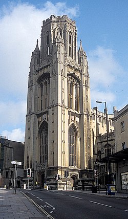
65.5 m (215 ft) 5 1925 Education Queens Road 51°27′22″N2°36′17″W / 51.456104°N 002.6046248°W Renovated 2006. Was Built to pay tribute to Henry Overton Wills III, The University Of Bristol's First Chancellor. Grade II* 7 Eclipse 
65 m (213 ft) 17 2007 Retail/residential Castle Park 51°27′26″N2°35′11″W / 51.457203°N 002.5862664°W Also known as Harvey Nichols Tower due to the lower floors being occupied by the department store. No Christ Church, Clifton Down 
65 m (213 ft) 5 1885 Religion Clifton 51°27′28″N2°37′11″W / 51.457689°N 002.6196773°W Grade II* 8 Beacon Tower 
64 m (210 ft) 18 1973 Office The Centre 51°27′17″N2°35′51″W / 51.454662°N 002.5974177°W Formerly Colston Tower. The tower was renamed as part a number of renamings across the city. This followed the toppling of the Edward Colston statue in June 2020. No One Redcliff Street 
64 m (210 ft) 16 1964 Office Redcliffe 51°27′10″N2°35′26″W / 51.452837°N 002.5904855°W No 9 Fusion Tower 
63 m (207 ft) 17 1971 Student accommodation Lewin's Mead 51°27′26″N2°35′42″W / 51.457112°N 002.5949809°W Formerly Froomsgate House, renovated 2017 No 10 Silverthorne Lane 
62 m (203 ft) 17 2024 Student accommodation St Phillip's Marsh 51°27′03″N2°34′03″W / 51.450972°N 002.5673997°W Topped out in 2025. No Clifton Heights 
62 m (203 ft) 14 [9] 1965 Office The Triangle 51°27′23″N2°36′30″W / 51.456327°N 002.6083893°W No 11 Radisson Blu 
61 m (200 ft) 17 1967 Hotel The Centre 51°27′09″N2°35′48″W / 51.452543°N 002.5966398°W Formerly Bristol & West Building, renovated 2008 No 12 St. Nicholas' Church [10] 
60 m (200 ft) 1 1769 Religion Old City 51°27′14″N2°35′33″W / 51.453917°N 002.5924234°W Former tallest building until 1872, when the restoration of St Mary Redlciffe spire was complete [6] Grade II* RAC Regional Control Centre 
60 m (200 ft) 1994 Office Bradley Stoke 51°32′58″N2°33′27″W / 51.549491°N 002.557545°W No St Michael's Hospital 
60 m (200 ft) 1 1975 Chimney stack Kingsdown 51°27′36″N2°36′00″W / 51.460023°N 002.6000429°W No The Bristol Wheel 
60 m (200 ft) N/A 2016 Ferris Wheel Millennium Square 51°27′01″N2°35′58″W / 51.450350°N 002.5994790°W Also known as the Bristol Eye (not to be confused with 'The Eye' at Temple Quarter) No 13 All Saints' Church 
59.5 m (195 ft) [11] 1 1716 Religion Old City 51°27′17″N2°35′36″W / 51.454688°N 2.593394°W Closed in 1984 Grade II* 14 Stafford Yard 
59 m (194 ft) 16 2023 Residential Bedminster 51°26′26″N2°35′48″W / 51.440671°N 002.5966868°W Topped out in 2024. No One Bristol 
59 m (194 ft) 15 1972 Residential Lewin's Mead 51°27′27″N2°35′45″W / 51.457398°N 002.5957333°W Formerly Greyfriars, renovated 2017 No 15 St Paul's Church 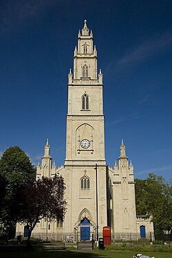
58 m (190 ft) [11] 1 1794 Circus (formerly Religion) St Paul's 51°27′40″N2°35′05″W / 51.46114°N 2.58472°W closed in 1988 due to declining congregation. After major restoration starting in 2001, the church reopened in 2005 now owned by Circomedia. Grade I Assembly Building A 
58 m (190 ft) 11 2022 Office Temple Quarter 51°27′13″N2°35′04″W / 51.453479°N 002.5844961°W BT Group [12] Office No 16 The Boatyard 
57 m (187 ft) 17 2023 Residential Totterdown 51°26′34″N2°34′22″W / 51.442854°N 002.5728768°W The development consists of two floors below streetlevel facing the river. The height excluding these two floors is 49 m. [13] No Assembly Building C 
57 m (187 ft) 12 2023 Office Temple Quarter 51°27′14″N2°35′05″W / 51.453972°N 002.5847469°W Topped out No 17 The Fairfax 
55 m (180 ft) 14 1962 Office Castle Park 51°27′21″N2°35′30″W / 51.455884°N 002.5917810°W Formerly Tower House, refurbishment and renaming completed in 2025. No 18 Marketgate 
53 m (174 ft) 16 1970 Student Accommodation Old Market 51°26′33″N2°35′56″W / 51.442575°N 002.5988312°W No 19 Northfield House 
52 m (171 ft) 18 1969 Residential Southville 51°26′33″N2°35′56″W / 51.442575°N 002.5988312°W No Millwrights Place 
52 m (171 ft) 14 2023 Residential Redcliffe 51°27′11″N2°35′13″W / 51.453134°N 002.5869128°W No 20 Holy Trinity Church 
51.5 m (169 ft) 1 1857 Religion Stapleton 51°28′53″N2°33′18″W / 51.481458°N 002.5549167°W Grade II* 21 New Bridewell Tower 
49 m (161 ft) 16 2017 Student accommodation Lewin's Mead 51°27′25″N2°35′36″W / 51.457077°N 002.5934695°W No Whitefriars 
49 m (161 ft) 13 1979 Office Lewin's Mead 51°27′28″N2°35′41″W / 51.457742°N 002.5946416°W No Clifton Cathedral 
49 m (161 ft) 1 1973 Religion Clifton 51°27′35″N2°36′59″W / 51.459723°N 002.6162535°W Grade II* Twinnell House 
49 m (161 ft) 17 1969 Residential Easton 51°27′44″N2°34′16″W / 51.462151°N 002.571198°W No Croydon House 
49 m (161 ft) 17 1969 Residential Easton 51°27′39″N2°34′09″W / 51.460833°N 2.569167°W No 22 Christ Church With St Ewen 
48.5 m (159 ft) 2 1791 Religion Old City 51°27′17″N2°35′37″W / 51.454722°N 2.593611°W Best known for its quarter-jacks which were mounted on each side of the church's clock. They were removed in 2013 for restoration but were unfortunately too badly damaged, rendering them unable to be re-erected. Funding for new quarter-jacks began with an appeal in 2018 and the new figures are expected to be installed around 2027. Grade II* 23 Barton House 
47 m (154 ft) 15 1958 Residential Barton Hill 51°27′14″N2°33′40″W / 51.453818°N 002.5610679°W Known for being the very first building In Bristol to be classified as a tower block; Almost Collapsed In 2024. No 24 St Stephen's Church 
46 m (151 ft) 1 1470 Religion Old City 51°27′15″N2°35′46″W / 51.454300°N 002.5960444°W Grade I Marsh Mills 
46 m (151 ft) 14 2024 Student accommodation St Phillip's Marsh 51°26′53″N2°34′34″W / 51.448177°N 002.5761920°W Topped out 2025. No Catherine's House 
46 m (151 ft) 14 2024 Residential Bedminster 51°26′29″N2°35′44″W / 51.441272°N 002.5956622°W Former office building. No 25 Bristol Cathedral 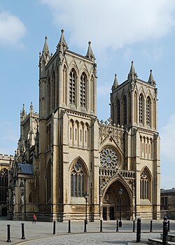
44 m (144 ft) 1 1877 Religion College Green 51°27′06″N2°36′03″W / 51.451657°N 002.6007155°W Built between 1220 and 1877. Grade I St Lawrence House 
44 m (144 ft) 12 1967 Student accommodation Broad Street 51°27′20″N2°35′42″W / 51.455605°N 002.595123°W Originally built as offices; contemporaneous with other towers in Lewin's Mead. No Corbett House 
44 m (144 ft) 14 1962 Residential Barton Hill 51°27′19″N2°33′42″W / 51.455354°N 002.5617725°W No 26 The Eye 
43 m (141 ft) 13 2012 Residential Temple Quarter 51°27′08″N2°34′54″W / 51.452208°N 002.5816825°W No Cheese Lane Shot Tower 
43 m (141 ft) 4 1969 Office Temple Quarter 51°27′13″N2°35′09″W / 51.45372°N 002.585744°W Formerly a structure, the tower now forms part of an office development called Vertigo. Grade II Longlands House 
43 m (141 ft) 15 1962 Residential Barton Hill 51°27′22″N2°33′45″W / 51.456138°N 002.5624242°W No 27 Temple Church 
40 m (130 ft) [11] 1 14th century Religion (until it was bombed) Redcliffe 51°27′07″N2°35′17″W / 51.452°N 2.588°W Destroyed by german bombings in 1940 during World War II. Despite the walls and tower still intact, the damages were too severe to be repaired. Garde II* Ashton Gate Stadium 
40 m (130 ft) N/A 1887 Stadium Ashton Gate 51°26′24″N2°37′13″W / 51.44°N 2.620278°W Home of both Bristol City F.C. and the Bristol Bears rugby union team. The stadium has a seating capacity of roughly 27,000. No


