Easton | |
---|---|
Boundaries of the city council ward. | |
Population | 13,541 (2011) [1] |
OS grid reference | ST605735 |
Unitary authority | |
Ceremonial county | |
Region | |
Country | England |
Sovereign state | United Kingdom |
Post town | BRISTOL |
Postcode district | BS5 |
Dialling code | 0117 |
Police | Avon and Somerset |
Fire | Avon |
Ambulance | South Western |
UK Parliament | |
Easton is an inner city area of the city of Bristol in the United Kingdom. Informally the area is considered to stretch east of Bristol city centre and the M32 motorway, centred on Lawrence Hill. Its southern and eastern borders are less defined, merging into St Philip's Marsh and Eastville. The area includes the Lawrence Hill and Barton Hill estates.
In administrative terms, Easton comprises the electoral wards of Easton and part of Lawrence Hill. It is located within the Bristol West constituency. The electoral ward of Easton includes parts of the localities of Netham and Whitehall, and a large part of Greenbank. The Bristol & Bath Railway Path passes through the ward.
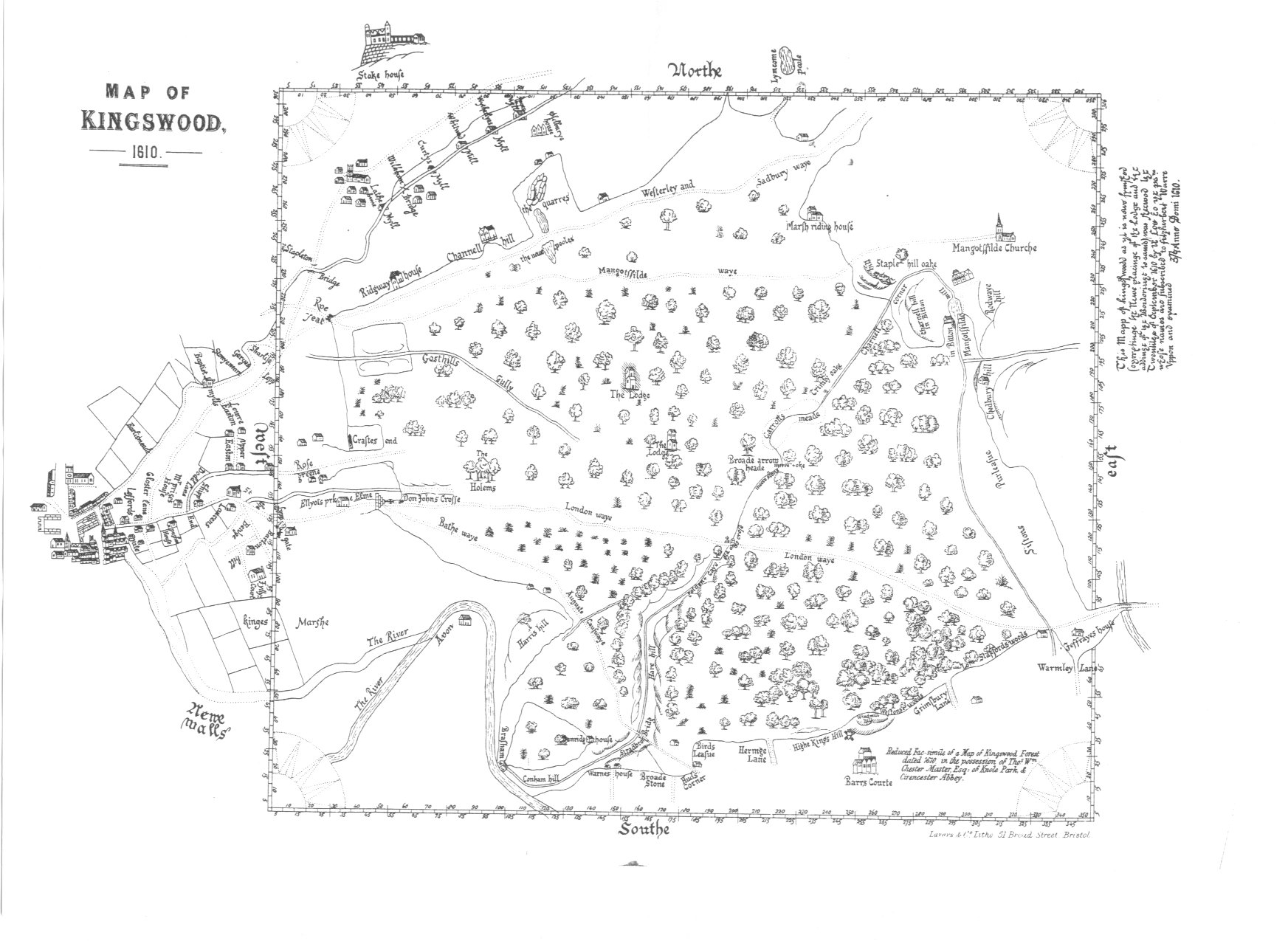
In the medieval period Easton lay within the Royal Forest of Kingswood in the manor of Barton Regis. The name Easton is probably derived from the Anglo-Saxon East Tun meaning East Farm. The earliest documentary reference to Easton is Chester and Master's 1610 Map of Kingswood, [2] which depicts three settlements: Upper Easton, which was centered on Easton Road, Lower Easton, which was centered on St Marks Road, and Baptist Mills, on the east bank of the River Frome.
In the post-medieval period the area became increasingly industrial with large scale extraction of coal, clay and sand occurring across the area. In the 19th century most of Easton was developed for housing.
In the late 1960s and 70s large areas of Easton were demolished to make way for new roads (A4320 Easton Way and the M32 Motorway) and housing estates.
During the 1990s UK crack cocaine and opioid epidemic, Easton was heavily hit with drugs. Drug gangs ran the streets of Easton throughout the 1990s and 2000s. There were several shootings in the area between another drug gang in St. Paul's, the two gangs turf were only divided the A4320 Easton Way and M32 Motoway. Gangs in Easton were still strong and violence still continued into the 2010s, by the early 2020s gang violence has drastically reduced and anti-social behaviour is on the decline. Parts of Easton have seen extremely high house price increases over the last decade. [3]
The Census 2011 reported that Easton has a higher proportion of under 10s and people in the 25-44 age group than the England and Wales average, but fewer 10 to 15 year olds and people aged over 45. [4]
Easton is one of the most deprived areas in the south west of England, with the Lawrence Hill ward the most deprived ward in the region and one of the most deprived in Britain. This has resulted in the area being granted European Union objective 2 status and 'New Deal for Communities' status by the UK government which is only granted to the most underprivileged urban wards. [5]
St Marks Road is a shopping street noted for the exuberant sculpted signs that hang above many of the shop doors, and the architecturally striking illuminated dome of Easton Mosque. There are a number of Moroccan and Indian subcontinent restaurants and shops specialising in organic and ethnic foods.
Banksy lived in Easton in the 1990s. [6] There are several of his artworks in the area, although the council inadvertently painted over one and another has had a tin of paint thrown over it. This was possibly done in response to the house that the art was attached to being sold as a piece of Banksy graffiti with a house thrown in for free. [7]
The area is home to Easton Leisure Centre.
Easton has two railway stations, Lawrence Hill and Stapleton Road, which are served by trains on the Severn Beach Line plus services to and from Gloucester and South Wales. The main line to South Wales, the Midlands, Scotland and London also passes through Lawrence Hill and Stapleton Road; after which the Severn Beach line branches off just north of. The M32 motorway marks the border of Easton to the north. The A4032 dual carriageway cuts the area in two.
South Gloucestershire is a unitary authority area in the ceremonial county of Gloucestershire, South West England. Towns in the area include Yate, Chipping Sodbury, Thornbury, Filton, Patchway and Bradley Stoke, the latter three forming part of the northern Bristol suburbs. The unitary authority also covers many outlying villages and hamlets. The southern part of its area falls within the Greater Bristol urban area surrounding the city of Bristol.
Kingswood is a suburban town and unparished area in the South Gloucestershire district, in the ceremonial county of Gloucestershire, England, bordering the eastern edge of the City of Bristol. The suburb is situated 3.4 miles (5.5 km) east-northeast of Bristol city centre and 102 miles (164 km) west of London.
The M32 is a 4.4 miles (7.1 km) long motorway in South Gloucestershire and Bristol, England. It provides a link from the M4, a major motorway linking London and South Wales, to Bristol city centre and is maintained by National Highways, the national roads body.
Avonmouth is a port and outer suburb of Bristol, England, facing two rivers: the reinforced north bank of the final stage of the Avon which rises at sources in Wiltshire, Gloucestershire and Somerset; and the eastern shore of the Severn Estuary. Strategically the area has been and remains an important part of the region's maritime economy particularly for larger vessels for the unloading and exporting of heavier goods as well as in industry including warehousing, light industry, electrical power and sanitation. The area contains a junction of and is connected to the south by the M5 motorway and other roads, railway tracks and paths to the north, south-east and east.
Stapleton is an area in the northeastern suburbs of the city of Bristol, England. The name is colloquially used today to describe the ribbon village along Bell Hill and Park Road in the Frome Valley. It borders Eastville to the South and Begbrook and Frenchay to the North. It comprises an eclectic mix of housing mainly from the Victorian, Edwardian, inter-war and late 20th century periods.
Ashley is one of thirty-five council wards in the city of Bristol in the United Kingdom. The ward contains the areas of Baptist Mills, Montpelier, St Andrew's, St Paul's and St Werburgh's. The Ward has over 16,000 residents and is served by one community magazine and resident-led organisational body called 'Vocalise'.
Stapleton Road railway station is on the Severn Beach Line and Cross Country Route, serving the inner-city district of Easton in Bristol, England. It is 1.6 miles (2.6 km) from Bristol Temple Meads. Its three letter station code is SRD. The station has two platforms, four running lines and minimal facilities. It is managed by Great Western Railway, the seventh company to be responsible for the station, and the third franchise since privatisation in 1997. They provide all train services at the station, the standard service being two trains per hour along the Severn Beach Line and an hourly service between Bristol Temple Meads and Filton Abbey Wood.
Eastville is the name of both a council ward in the city of Bristol in the United Kingdom and a suburb of the city that lies within that ward. The Eastville ward covers the areas of Eastville, Crofts End, Stapleton and part of Fishponds. Notable places within the ward include Bristol Metropolitan Academy and Colston's School, and the Bristol and Bath Railway Path also passes through the ward.
St George is a district of Bristol, England on the Eastern edge of the city boundary.
The city of Bristol, England, is divided into many areas, which often overlap or have non-fixed borders. These include Parliamentary constituencies, council wards and unofficial neighbourhoods. There are no civil parishes in Bristol.
Barton Hill is an area of Bristol, just to the east of the city centre and Bristol Temple Meads railway station.
Redfield is an area situated in East Bristol though it is represented in Westminster as part of the Bristol West constituency. It includes the stretch of Church Road (A420) from Verrier Road to the western boundary of St George's Green, Victorian-era landscaped parkland. It is adjacent to the neighbourhoods of Barton Hill and Russell Town to the South, St George to the East, Whitehall to the North and Lawrence Hill to the West and Pile Marsh to the South-East.
Lawrence Hill railway station is on the Severn Beach Line and Cross Country Route, serving the inner-city districts of Easton and Lawrence Hill in Bristol, England. It is 1.0 mile (1.6 km) from Bristol Temple Meads. Its three letter station code is LWH. The station has two platforms, four running lines and minimal facilities. It is managed by Great Western Railway, the seventh company to be responsible for the station and the third franchise since privatisation in 1997. They provide all train services at the station, the standard service being two trains per hour along the Severn Beach Line and an hourly service between Bristol Temple Meads and Filton Abbey Wood.
Baptist Mills an area of the city of Bristol, England. The name derives from the former mills which stood in that area.
Lawrence Hill is an electoral ward of Bristol, United Kingdom and includes the districts of Barton Hill, St Philips Marsh and Redcliffe, Temple Meads and parts of Easton and the Broadmead shopping area. Lawrence Hill takes its name from a leper hospital dedicated to St Lawrence, which was founded by King John.
The Bristol underground scene a cultural movement in Bristol beginning in the early 1980s. The scene was born out of a lack of mainstream clubs catering for the emergence of hip hop music, with street and underground parties a mainstay. Crews formed playing hip hop in disused venues with sound systems borrowed from the reggae scene: City Rockers, 2 Bad, 2 Tuff, KC Rock, UD4, FBI, Dirty Den, Juice Crew, Rene & Bacus, Soul Twins, KC Rock, Fresh 4, and The Wild Bunch were among them. These names were the precursors to the more well known names that came from this scene. It is characterized by musicians and graffiti artists. The scene was influenced by the city's multiculturalism, political activism, and the arts movements of punk, reggae, hip hop, hippies and new age.
St Jude's is a mixed residential, commercial and light industrial area of central Bristol, England. St Jude's forms part of the Lawrence Hill ward of Bristol City Council.
Stapleton Road is a major thoroughfare in the English city of Bristol, running through the districts of Lawrence Hill and Easton. It is known for being very culturally diverse with many esoteric shops. However since the mid 20th century it has gained a reputation for having a high crime rate.
Blackberry Hill Hospital is an NHS psychiatric hospital in Fishponds, Bristol, England, specialising in forensic mental health services, operated by the Avon and Wiltshire Mental Health Partnership NHS Trust. The hospital also offers drug and alcohol rehabilitation inpatient services, and is the base for a number of community mental health teams.
{{cite web}}
: CS1 maint: archived copy as title (link) 2011 Census