Bishopston, Bristol

Last updated

Bishopston
Bristol bishopston.png
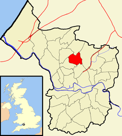
Boundaries of the Council Ward, shown within Bristol.
Population13,871 (2011.Ward) [1]
OS grid reference ST586755
Unitary authority
Ceremonial county
Region
Country England
Sovereign state United Kingdom
Post town Bristol
Postcode district BS7
Dialling code 0117
Police Avon and Somerset
Fire Avon
Ambulance South Western
UK Parliament
List of places
UK
England
Bristol

Bishopston is a suburb of the city of Bristol in south west England. Bishopston is around Gloucester Road (A38), the main northern arterial road in the city and Bishop Road.

Contents

Bishopston is named after the bishop of the local diocese who controversially sold off the church's land to private developers in the early 19th century. The sale was even raised as an issue in the House of Commons. The parish of Bishopston was then created in July 1862 with a population of 1300 and expanding to 9140 in the 1901 census. In the 2001 census Bishopston registered a resident population of 11,996. The district is part of the Bristol built-up area, having been swallowed by the growing city, running directly into the surrounding districts of Redland, Ashley Down, Horfield and Henleaze.

The area has a relatively large student population, with 21% of the over-16 population in education compared to 8.4% in Bristol and 5.1% in England and Wales.

Bristol North swimming baths and The Bristol Flyer Pub Only Fools and Horses Location Bristol Flyer & Bristol North Baths, Gloucester Road, Bristol 1999.jpg
Bristol North swimming baths and The Bristol Flyer Pub

Some of the location filming for the cult BBC sitcom The Young Ones was done in Codrington Road and elsewhere. The external shots for the famous "bank-robbing" scene in the last episode were filmed outside the now closed Bristol North Swimming Baths on Gloucester Road.

Bishopston was the home of two Nobel Prize–winning physicists. In 1933 Paul Dirac, who attended the Bishop Road Primary School, just a few hundred metres from where he lived on Monk Road, won the prize after his contributions to quantum mechanics. In 1950 Cecil Frank Powell won the prestigious award for contributions to Physics (specifically, for his development of the photographic method of studying nuclear processes and his discoveries regarding mesons made with this method). Bishopston was home to television presenter Adam Hart-Davis and psychologist Susan Blackmore.

The famous film star Cary Grant (real name Archibald Alexander Leach) attended Bishop Road School in Bishopston. As a child he lived nearby in Hughenden Road next to Horfield Common, where there is a blue plaque to commemorate him.

Bishopston has two primary schools, St. Bonaventure's Catholic Primary School which served the huge Italian Irish and South American Catholic community and Bishop Road Primary School COE which was a secondary school up until the mid-1980s and served children of the Anglican faith and drew in children from the Asian and Jamaican community in St Paul's and Montpellier.
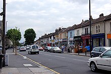
Gloucester Road, the main route through Bishopston, is known for its independent shops. Bishopston, Bristol, England, UK.jpg
Gloucester Road, the main route through Bishopston, is known for its independent shops.

The main artery, Gloucester Road, is a traditional local High Street, [2] and well used by local residents. In addition to the independently run shops such as Scoopaway, La Ruca, Gardener's Patch and Harvest, recent years have seen several supermarket chains opening stores in the area, as well as a number of cafés, restaurants, and pubs. This, together with the range of fairly traded and local goods available, has made it popular with ecologically minded shoppers.

Bishopston is home to Gloucestershire County Cricket Club, located off Nevil Road. The ground's capacity has been increased to hold international cricket matches.

The David Thomas Memorial church, in neighbouring St Andrews, was erected between 1879 and 1881 but was demolished in 1987, destroying most of a Gothic fantasy by Stuart Coleman. The building still retains a thin octagonal spire and west front but the massive halls, apse and rib vaults have now gone, and have been replaced by flats by Stride Treglown.

Politics

For elections to Bristol City Council, it is split between the electoral wards of Redland and Bishopston and Ashley Down. The boundary between the two wards runs along Gloucester Road and then the southern perimeters of HMP Bristol and the playing fields of Bishop Road Primary and Redland Green School, with areas to the southwest in Redland ward. [3]

For elections to the UK Parliament, Redland ward is in Bristol Central constituency, and the Bishopston and Ashley Down ward is in Bristol North West constituency.

Before boundary changes in 2016, Bishopston was itself an electoral ward. [3]

Education

Bishopston is the location of Bishop Road Primary School, which opened in 1900, [4] and is the largest primary school in Bristol, [5] notable for having educated Cary Grant and Paul Dirac. [6]

Related Research Articles

<span class="mw-page-title-main">Cotham, Bristol</span> Human settlement in England

Cotham is an area of Bristol, England, about 1 mile north of the city centre. It is an affluent, leafy, inner city suburb situated north of the neighbourhoods of Kingsdown and St Paul’s and sandwiched between Gloucester Road (A38) to the east, and Hampton Road to the west.

<span class="mw-page-title-main">Horfield</span> Suburb of Bristol, England

Horfield is a suburb of the city of Bristol, in southwest England. It lies on Bristol's northern edge, its border with Filton marking part of the boundary between Bristol and South Gloucestershire. Bishopston lies directly to the south. Monks Park and Golden Hill are to the west. Lockleaze and Ashley Down are on the eastern fringe. The Gloucester Road (A38) runs north–south through the suburb.

<span class="mw-page-title-main">Bristol West (UK Parliament constituency)</span> Parliamentary constituency in the United Kingdom, 1885–2024

Bristol West was a borough constituency represented in the House of Commons of the Parliament of the United Kingdom since 2015 by Thangam Debbonaire of the Labour Party. It mostly covered the central and western parts of Bristol.

<span class="mw-page-title-main">Bristol North West (UK Parliament constituency)</span> Parliamentary constituency in the United Kingdom, 1950 onwards

Bristol North West is a constituency represented in the House of Commons of the UK Parliament since 2017 by Darren Jones of the Labour Party.

<span class="mw-page-title-main">Redland, Bristol</span> Human settlement in England

Redland is a neighbourhood in Bristol, England. The neighbourhood is situated between Clifton, Cotham, Bishopston and Westbury Park. The boundaries of the district are not precisely defined, but are generally taken to be Whiteladies Road in the west, the Severn Beach railway line in the south and Cranbrook Road in the east.

<span class="mw-page-title-main">Henleaze</span> Suburb of Bristol, England

Henleaze is a suburb in the north of the city of Bristol in South West England. It is an almost entirely residential interwar development, with Edwardian streets on its southern fringes. Its main neighbours are Westbury on Trym, Horfield, Bishopston and Redland.

<span class="mw-page-title-main">Diocese of Bristol</span> Diocese of the Church of England

The Diocese of Bristol is an ecclesiastical jurisdiction or diocese of the Church of England in the Province of Canterbury, England. It is based in the city of Bristol and covers South Gloucestershire and parts of north Wiltshire, as far east as Swindon. The diocese is headed by the Bishop of Bristol and the Episcopal seat is located at the Cathedral Church of the Holy and Undivided Trinity, commonly known as Bristol Cathedral.

<span class="mw-page-title-main">Golden Hill, Bristol</span> Human settlement in England

Golden Hill is an inner suburb of Bristol, England, lying east of Horfield Common and north-east of Bishopston. Redland and Henleaze are nearby. The housing is mainly in private ownership and was built in the 1920s and 1930s.

<span class="mw-page-title-main">Monks Park</span> Suburb of Bristol, England

Monks Park is a northern suburb of the city of Bristol, England, and is the highest point within the city. Monks Park stretches westward, towards Southmead, from the A38 trunk road. Filton Park lies directly north, on the South Gloucestershire side of the city boundary. Horfield lies to the east of the A38 and also to the south.

The city of Bristol, England, is divided into many areas, which often overlap or have non-fixed borders. These include Parliamentary constituencies, council wards and unofficial neighbourhoods. There are no civil parishes in Bristol.

Ashley Down is a residential neighbourhood in the north of Bristol, England. It lies on high ground east of Bishopston, north of St Andrews and St Werburghs, west of Muller Road and south of Horfield. The main artery is Ashley Down Road. It is in the Bishopston and Ashley Down electoral ward of Bristol City Council.

<span class="mw-page-title-main">Gloucester Road, Bristol</span> Street in Bristol, United Kingdom

Gloucester Road is a road in Bristol, England. It runs through the suburbs of St. Andrew's, Bishopston and Horfield and is a part of the A38, a former coaching route north of Bristol to Filton and the M5 Motorway.

<span class="mw-page-title-main">2009 Bristol City Council election</span> 2009 UK local government election

The 2009 Bristol City Council elections were held on Thursday 4 June 2009, for 23 seats, that being one-third of the total number of councilors. The Liberal Democrats who had been leading a minority administration, won an overall majority of the council, the first time the party had achieved this on Bristol City Council. The Liberal Democrats were defending 11 seats, the Labour Party 10 and the Conservatives 2.

Bishop Road Primary School is a primary school in Bristol, England. It is on Bishop Road in the Bishopston area of Bristol. The school opened in 1896. It is the largest primary school in Bristol, notable for having educated Cary Grant and Paul Dirac. The headteacher is Gillian Powe.

<span class="mw-page-title-main">2013 Bristol City Council election</span> 2013 UK local government election

Elections for one third of Bristol City Council were held on 2 May 2013 as part of the 2013 United Kingdom local elections. No party gained overall control of the chamber, although administrative power rested with the Mayor of Bristol, who had been first elected in November 2012

<span class="mw-page-title-main">2014 Bristol City Council election</span> 2014 UK local government election

The 2014 Bristol City Council election took place on 22 May 2014 to elect members of Bristol City Council in England, as part of the United Kingdom 2014 Local Elections.

<span class="mw-page-title-main">2021 Bristol City Council election</span> 2021 UK local government election

The 2021 Bristol City Council election took place on 6 May 2021 to elect members of Bristol City Council in England. It coincided with nationwide local elections. Voters in the city also voted for the mayor of Bristol, the mayor of the West of England and for Avon and Somerset's police and crime commissioner. The election was originally due to take place in May 2020, but was postponed due to the COVID-19 pandemic.

<span class="mw-page-title-main">Bishopston and Ashley Down</span>

Bishopston and Ashley Down is one of the thirty-four electoral wards in the city of Bristol in the Southwest of England, United Kingdom. It is represented by two councillors on Bristol City Council, which as of 2024 are Emma Edwards and James Crawford, both members of the Green Party.

<span class="mw-page-title-main">2024 Bristol City Council election</span> Local election in Bristol, England

The 2024 Bristol City Council election was held on Thursday 2 May 2024, alongside the other local elections in the United Kingdom. It elected all 70 councillors to the Bristol City Council for a four-year term.

References

  1. "Bishopston" (PDF). 2011 Census Ward Information Sheet. Retrieved 26 February 2015.[ permanent dead link ]
  2. "The last great British high street". The Independent . London. 8 August 2004. Archived from the original on 1 October 2007.
  3. 1 2 "Bristol". Local Government Boundary Commission for England.
  4. "Bishop Road Primary School Inspection Report" (PDF). Ofsted. 19 May 2011. Retrieved 12 August 2012.[ permanent dead link ]
  5. "Bristol's biggest primary school gets even bigger". This Is Bristol. 31 August 2009. Archived from the original on 5 May 2013. Retrieved 12 August 2012.
  6. "Bristol celebrates Hollywood 'son'". BBC. 8 December 2001. Retrieved 12 August 2012.

51°28′37″N2°35′51″W / 51.47693°N 2.59751°W / 51.47693; -2.59751