Avonmouth is a port and outer suburb of Bristol, England, facing two rivers: the reinforced north bank of the final stage of the Avon which rises at sources in Wiltshire, Gloucestershire and Somerset; and the eastern shore of the Severn Estuary. Strategically the area has been and remains an important part of the region's maritime economy particularly for larger vessels for the unloading and exporting of heavier goods as well as in industry including warehousing, light industry, electrical power and sanitation. The area contains a junction of and is connected to the south by the M5 motorway and other roads, railway tracks and paths to the north, south-east and east.

Clifton is both a suburb of Bristol, England, and the name of one of the city's thirty-five council wards. The Clifton ward also includes the areas of Cliftonwood and Hotwells. The eastern part of the suburb lies within the ward of Clifton Down.

Bristol City Centre is the commercial, cultural and business centre of Bristol, England. It is the area north of the New Cut of the River Avon, bounded by Clifton Wood and Clifton to the north-west, Kingsdown and Cotham to the north, and St Pauls, Lawrence Hill and St Phillip's Marsh to the east. The Bristol Royal Infirmary, Bristol Royal Hospital for Children, the BBC, the main campus of the University of Bristol, the Crown and Magistrate's Courts, Temple Meads railway station, Bristol bus station, the Park Street, Broadmead and Cabot Circus shopping areas together with numerous music venues, theatres and restaurants are located in this area. The area consists of the council wards of Central, Hotwells & Harbourside, and part of Lawrence Hill.

Cotham is an area of Bristol, England, about 1 mile north of the city centre. It is an affluent, leafy, inner city suburb situated north of the neighbourhoods of Kingsdown and St Paul’s and sandwiched between Gloucester Road (A38) to the east, and Hampton Road to the west.

Bedminster is a district of Bristol, England, on the south side of the city. It is also the name of a council ward which includes the central part of the district.

Bristol West is a borough constituency represented in the House of Commons of the Parliament of the United Kingdom since 2015 by Thangam Debbonaire of the Labour Party. It mostly covers the central and western parts of Bristol.

Redland is a neighbourhood in Bristol, England. The neighbourhood is situated between Clifton, Cotham, Bishopston and Westbury Park. The boundaries of the district are not precisely defined, but are generally taken to be Whiteladies Road in the west, the Severn Beach railway line in the south and Cranbrook Road in the east.

Cabot was a council ward that covered the centre of Bristol, England. It took its name from the Cabot Tower, a memorial tower on Brandon Hill that was built to commemorate John Cabot's voyage and "discovery" of North America. The ward was abolished in 2016.

Bristol Tramways operated in the city of Bristol, England from 1875, when the Bristol Tramways Company was formed by Sir George White, until 1941 when a Luftwaffe bomb destroyed the main power supply cables.

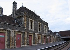
Clifton Down railway station is on the Severn Beach line and serves the district of Clifton in Bristol, England. It is 3.9 miles (6.3 km) from Bristol Temple Meads. Its three letter station code is CFN. The station has two platforms, each serving trains in one direction only. As of 2015 it is managed by Great Western Railway, which is the third franchise to be responsible for the station since privatisation in 1997. They provide all train services at the station, mainly a train every 30 minutes in each direction.
The city of Bristol, England, is divided into many areas, which often overlap or have non-fixed borders. These include Parliamentary constituencies, council wards and unofficial neighbourhoods. There are no civil parishes in Bristol.
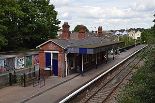
Redland railway station is on the Severn Beach Line and serves the districts of Cotham and Redland in Bristol, England. It is 3.3 miles (5.3 km) from Bristol Temple Meads. Its three letter station code is RDA. As of 2015 it is managed by Great Western Railway, which is the third franchise to be responsible for the station since privatisation in 1997. They provide all train services at the station, mainly a train every 30 minutes in each direction.
Hotwells is a district of the English port city of Bristol. It is located to the south of and below the high ground of Clifton, and directly to the north of the Floating Harbour. The southern entrance to the Avon Gorge, which connects the docks to the sea, lies at the western end of Hotwells. The eastern end of the area is at the roundabout where Jacobs Well Road meets Hotwell Road. Hotwells is split between the city wards of Clifton, and Hotwells and Harbourside.

Whiteladies Road is a main road in Bristol, England. It runs north from the Victoria Rooms to Durdham Down, and separates Clifton on the west side from Redland and Cotham on the east. It forms part of the A4018.

Clifton East was one of the thirty-five council wards in Bristol, England. As the name suggests, the ward covered the eastern part of the Clifton area of Bristol. The ward ceased to exist in May 2016 following a boundary review. It was mostly replaced by a new ward called Clifton Down, with the south-west corner of Clifton East being moved into the neighbouring ward of Clifton.”

Tyndall's Park is an area of central Bristol, England. It lies north of Park Row and Queen's Road, east of Whiteladies Road and west of St Michael's Hill, between the districts of Clifton, Cotham and Kingsdown. It includes the campus of Bristol Grammar School, and many of the buildings of the University of Bristol.

The 2011 Bristol City Council elections were held on Thursday 5 May 2011, for 24 seats, that being one third of the total number of councillors. The Liberal Democrats, who had won overall control of the council in 2009 and increased their majority in 2010, experienced a drop in support and lost 5 seats; 4 to the Labour Party and 1 to the Green Party, which gained its second ever council seat in Bristol. This meant that the Lib Dems no longer had a majority on the council. However, they continued to run the council, relying on opposition groups to vote through any proposal.
The 2015 Bristol City Council election took place on 7 May 2015 to elect members of Bristol City Council in England. This was on the same day as other local elections.

The 2021 Bristol City Council election took place on 6 May 2021 to elect members of Bristol City Council in England. It coincided with nationwide local elections. Voters in the city also voted for the mayor of Bristol, the mayor of West of England and for Avon and Somerset's police and crime commissioner. The election was originally due to take place in May 2020, but was postponed due to the COVID-19 pandemic.