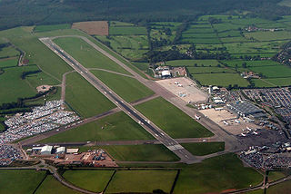
Bristol Airport, at Lulsgate Bottom, on the northern slopes of the Mendip Hills, in North Somerset, is an international airport serving the city of Bristol, England, and the surrounding area. It is 7 nautical miles southwest of Bristol city centre. Built on the site of a former RAF airfield, it opened in 1957 as Bristol (Lulsgate) Airport, replacing Bristol (Whitchurch) Airport as Bristol's municipal airport. From 1997 to 2010, it was known as Bristol International Airport. In 1997, a majority shareholding in the airport was sold to FirstGroup, and then in 2001 the airport was sold to a joint venture of Macquarie Bank and others. In September 2014, Ontario Teachers' Pension Plan bought out Macquarie to become the sole owner.

Knowle is a district and council ward in south east Bristol, England, bordered by Filwood Park to the west, Brislington to the east, Whitchurch and Hengrove to the south and Totterdown to the north. The settlement was mentioned in the Domesday Book as Canole. Knowle comes from the old English word for hillock, which means a little hill.

Knowle West is a neighbourhood in the south of Bristol, England, 2 miles (3 km) from the city centre, and mostly in the Filwood ward of Bristol City Council, although a small part of the estate lies within Knowle ward to the east. To the west are Bishopsworth and Hartcliffe, to the north Bedminster and Windmill Hill and to the south Whitchurch Park and Hengrove. In 2008, the population was 11,787.

Whitchurch is a suburb and community in the north of Cardiff, capital of Wales. It is approximately 3 miles north of the centre of the city on the A470 road and A4054 road. It falls within the Whitchurch & Tongwynlais ward. The population of the community in 2011 was 14,267.

Horfield is a suburb of the city of Bristol, in southwest England. It lies on Bristol's northern edge, its border with Filton marking part of the boundary between Bristol and South Gloucestershire. Bishopston lies directly to the south. Monks Park and Golden Hill are to the west. Lockleaze and Ashley Down are on the eastern fringe. The Gloucester Road (A38) runs north–south through the suburb.

Bristol South is a constituency represented in the House of Commons of the UK Parliament since 2015 by Karin Smyth of the Labour Party.

Whitchurch is a village in north Somerset, England and an adjoining suburb of southern Bristol, bounded by Hartcliffe to the west and Hengrove and Knowle to the north. The suburb was initially developed during the 1930s.
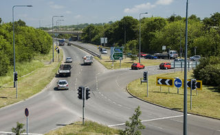
The A4174 is a major ring road in England which runs around the northern and eastern edge of Bristol, mainly in South Gloucestershire, and through the southern suburbs of the city. When it was first conceived it was planned to circle the whole of Bristol, and is commonly referred to as the "Avon Ring Road", or less accurately the "Bristol Ring Road", on road signs. The road does not circle the whole city, instead covering roughly half of the route. It is broken in part where it is concurrent with the A4.
The city of Bristol, England, is divided into many areas, which often overlap or have non-fixed borders. These include Parliamentary constituencies, council wards and unofficial neighbourhoods. There are no civil parishes in Bristol.
Bristol is a city in south west England, near the Bristol Channel coast, approximately 106 miles (170 km) west of London. Several factors have influenced the development of its transport network. It is a major centre of employment, retail, culture and higher education, has many historic areas, and has a history of maritime industry. The city has a population of 450,000, with a metropolitan area of 650,000, and lies at the centre of the former County of Avon, which includes many dormitory towns, and has a population of one million.

Bishopsworth is the name of both a council ward of the city of Bristol in the United Kingdom, and a suburb of the city which lies within that ward. Bishopsworth contains many council estates.

Whitchurch Circuit was a motor racing circuit located at the former Bristol (Whitchurch) Airport in Bristol, England.

South Bristol Community Hospital is a community hospital in the Hengrove area of Bristol, England, on the site of the former Whitchurch Airport. It opened in March 2012. It is managed by the University Hospitals Bristol and Weston NHS Foundation Trust.

Bristol (Whitchurch) Airport, also known as Whitchurch Airport, was a municipal airport in Bristol, England, three miles (5 km) south of the city centre, from 1930 to 1957. It was the main airport for Bristol and the surrounding area. During World War II, it was one of the few civil airports in Europe that remained operational, enabling air connections to Lisbon and Shannon and onwards to the United States.

Bristol has a number of notable professional sports teams and a large number of active amateur sports clubs. There are also large numbers of participants in individual sports. The city has two Football League clubs: Bristol City F.C., who play in the second tier, and Bristol Rovers F.C., who play in the third tier. Gloucestershire County Cricket Club has its headquarters in the city. Bristol Bears are currently in Premiership Rugby.
This article lists proposed developments to transport in Bristol, England.
Leavesden is a residential and commercial area in the northern part of Watford, England. It lies within the M25 Motorway. On its eastern side it is bounded by the M1 Motorway. Leavesden is split into two councils which are Watford Borough Council and Three Rivers District Council. Leavesden Green is an adjoining residential community which lies partly in Three Rivers and partly in the Borough of Watford.

MetroBus is a bus rapid transit system in Bristol, England, created as a joint project between Bristol, North Somerset and South Gloucestershire councils. The first route, service m3, began operations on 29 May 2018, followed by m2 on 3 September 2018, m1 on 6 January 2019 and m4 on 22 January 2023.
South Bristol is the part of Bristol, England south of the Bristol Avon. It is almost entirely made up of the areas of the city historically in Somerset, and since the abolition of the county Avon, consists of the southern suburbs in the county of Bristol. Definitions sometimes also include areas of North Somerset, including Long Ashton, Nailsea and Backwell.
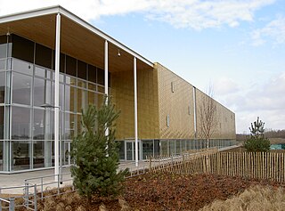
Hengrove Park Leisure Centre is a leisure centre in Hengrove, Bristol, UK.

