
Gloucestershire is a ceremonial county in South West England. It is bordered by Herefordshire to the north-west, Worcestershire to the north, Warwickshire to the north-east, Oxfordshire to the east, Wiltshire to the south, Bristol and Somerset to the south-west, and the Welsh county of Monmouthshire to the west. The city of Gloucester is the largest settlement and the county town.

Wiltshire is a ceremonial county in South West England. It borders Gloucestershire to the north, Oxfordshire to the north-east, Berkshire to the east, Hampshire to the south-east, Dorset to the south, and Somerset to the west. The largest settlement is Swindon, and Trowbridge is the county town.

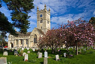
Thornbury is a market town and civil parish in the South Gloucestershire unitary authority area of England, about 12 mi (19 km) north of Bristol. It had a population of 12,063 at the 2011 census. The population has risen to 14,496 in the 2021 census. Thornbury is a Britain in Bloom award-winning town, with its own competition: Thornbury in Bloom. The earliest documentary evidence of a village at "Thornbyrig" dates from the end of the 9th century. The Domesday Book of 1086 noted a manor of "Turneberie" belonging to William the Conqueror’s consort, Matilda of Flanders, with 104 residents.

South Gloucestershire is a unitary authority area in the ceremonial county of Gloucestershire, South West England. Towns in the area include Yate, Chipping Sodbury, Kingswood, Thornbury, Filton, Patchway and Bradley Stoke. The southern part of its area falls within the Greater Bristol urban area surrounding the city of Bristol.

Bradley Stoke is a town and civil parish in South Gloucestershire, England, situated 6 miles north-northeast of Bristol city centre. The town is the northernmost part of the Bristol built-up area.

Trowbridge is the county town of Wiltshire, England; situated on the River Biss in the west of the county, close to the border with Somerset. The town lies 8 miles (13 km) south-east of Bath, 31 miles (50 km) south-west of Swindon and 20 miles (32 km) south-east of Bristol. The parish had a population of 37,169 in 2021.

Yate is a town and civil parish in South Gloucestershire, England. It lies just to the southwest of the Cotswold Hills and is 12 miles northeast of Bristol and 12 miles from Bath.

Berkeley is a market town and civil parish in the Stroud District in Gloucestershire, England. It lies in the Vale of Berkeley between the east bank of the River Severn and the M5 motorway. The town is noted for Berkeley Castle, where the imprisoned King Edward II is believed to have been murdered, as well as the birthplace of the physician Edward Jenner, pioneer of the smallpox vaccine, the world's first vaccine. The parish includes the village of Berkeley Heath.

Charfield is a village and civil parish in Gloucestershire, England, south-west of Wotton-under-Edge near the Little Avon River and the villages of Falfield and Cromhall. The parish includes the hamlet of Churchend.

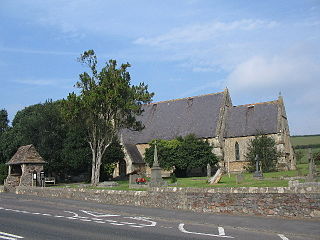
Almondsbury is a large village and civil parish in South Gloucestershire, England. It is situated on the A38 road in the Avon Green Belt 7 miles (11 km) north of Bristol city centre. It is adjacent to junction 16 of the M5 motorway and Almondsbury Interchange, where the M4 and M5 cross. It is part of the Bristol Built-up Area.

Filton is a town and civil parish in South Gloucestershire, England, 6 miles (10 km) north of Bristol. Along with nearby Patchway and Bradley Stoke, Filton forms part of the Bristol urban area and has become an overflow settlement for the city. Filton Church dates back to the 12th century and is designated a Grade II listed building.
Bishop's Cleeve is a village and civil parish in the Borough of Tewkesbury in the ceremonial county of Gloucestershire, England. The village lies at the foot of Cleeve Hill, the highest point in the Cotswolds. Bishop's Cleeve had a population of 10,612 in 2011, which has increased to 14,068 in the 2021 Census. The village is 13 miles (21 km) from Gloucester and 44 miles (71 km) from Oxford. The village is also close to the towns of Cheltenham, Tewkesbury and Evesham.

Churchdown is a large village in Gloucestershire, England, situated between Gloucester and Cheltenham in the south of the Tewkesbury Borough.

Stone is a small village in the parish of Ham and Stone, Gloucestershire, England. It stands on the A38 road, just south-west of its crossing of the Little Avon River, roughly halfway between Bristol and Gloucester at grid reference ST684953. It is adjacent to the county boundary with South Gloucestershire. The part of the community just north-east of the river is called Woodford. In 2019 it had an estimated population of 527.

Frampton Cotterell is a village and civil parish in South Gloucestershire, England, on the River Frome. The village is contiguous with Winterbourne to the south-west and Coalpit Heath to the east. The parish borders Iron Acton to the north and Westerleigh to the south-east, the large town of Yate is 2 miles away. The village is 8 miles north-east of Bristol. The population of the village together with the adjoining village of Winterbourne was 14,694 in 2011. The population of the parish alone was 6,520 at the 2011 census.

Pucklechurch is a civil parish in South Gloucestershire, England, the main settlement of which is the large village of Pucklechurch. The parish also incorporates the hamlet of Shortwood to the west of Pucklechurch village, and Parkfield to the north-west. It has a current population of just over 3200 based on the 2021 census data. The village dates back over a thousand years and was once the site of a royal hunting lodge, as it adjoined a large forest.
Wick is a village in South Gloucestershire, England. It is the main settlement in the civil parish of Wick and Abson. The population of this civil parish taken at the 2011 census was 1,989.

Longwell Green Sports Football Club is a football club based in the South Gloucestershire suburb of Longwell Green, in England. Affiliated to the Gloucestershire County FA, they are currently members of the Western League Division One and play at the Longwell Green Community Stadium.
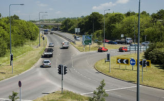
The A4174 is a major ring road in England which runs around the northern and eastern edge of Bristol, mainly in South Gloucestershire, and through the southern suburbs of the city. When it was first conceived it was planned to circle the whole of Bristol, and is commonly referred to as the "Avon Ring Road", or less accurately the "Bristol Ring Road", on road signs. The road does not circle the whole city, instead covering roughly half of the route. It is broken in part where it is concurrent with the A4.

Ram Hill is a hamlet in the civil parish of Westerleigh and Coalpit Heath, in the South Gloucestershire district, in the ceremonial county of Gloucestershire, England. It is located between Coalpit Heath and Westerleigh and adjoins the hamlet of Henfield immediately to the south. In the Mudge Map 1815, Ram Hill was known as Nutridge Hill, and was linked to Westerleigh by Broad Lane and to Mays Hill by Frog Lane.

